
FCCInfo.com
A Service of Cavell, Mertz & Associates, Inc.
(855) FCC-INFO
|
|
KNSO from 04/15/1991 KNSO from 10/02/1989 |
Post-repack Channel 27 Virtual Channel 51 |
|
|||||||||||||||||||
|
|
Repacking Information: Pre-Repack Channel: 43 Post-Repack Channel: 27 Post-Repack ERP: 205 kW Phase: 1 Completion Deadline: 11/30/2018 Find nearby TV Facilities Status: License Application Accepted: 05/18/2022 License Expires: 12/01/2022 File Number: -0000190993 FCC Website Links: LMS Facility Details This Application Other KNSO Applications Including Superseded Applications Mailing Address Correspondence for KNSO Correspondence related to application -0000190993 Service Contour - Open Street Map or USGS Map (41 dBu) Service Contour - KML / Google Earth (41 dBu) Public Inspection Files Rabbit Ears Info Search for KNSO Site Location: 37-04-19.1 N 119-25-52.5 W (NAD 83) Site Location: 37-04-19.3 N 119-25-49.0 W (Converted to NAD 27) ERP: 385 kW Polarization: Elliptically polarized HAAT: 578 m (1896 ft.) Electrical Beam Tilt: 1.5 degrees R/C AGL: 54 m (177 ft.) R/C AMSL: 1409.1 m (4623 ft.) Site Elevation: 1355.1 m. (4446 ft.) Height Overall*: 75.6 m (248 ft.) (* As Filed In This Application, may differ from ASR Data, Below.) Directional Antenna - Antenna Make/Model: DIELECTRIC TFU-24DSB/VP-N-R Antenna ID: 1009585 Polarization: Elliptically polarized | |||||||||||||||||||||
| Antenna Data for Antenna Id: 1009585 KNSO DT File: -0000190993 DIELECTRIC - TFU-24DSB/VP-N-R Service: DT Standard Pattern: N Pattern and Field Values Include a 225° Clockwise Rotation | 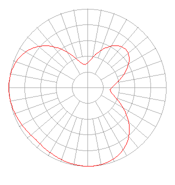 | |||||||||||||||||||||
| Azimuth | Ratio | Azimuth | Ratio | Azimuth | Ratio | Azimuth | Ratio | |||||||||||||||
| 5 | 0.342 | 15 | 0.441 | 25 | 0.554 | 35 | 0.648 | |||||||||||||||
| 45 | 0.686 | 55 | 0.646 | 65 | 0.551 | 75 | 0.438 | |||||||||||||||
| 85 | 0.339 | 95 | 0.292 | 96 | 0.292 | 105 | 0.329 | |||||||||||||||
| 115 | 0.446 | 125 | 0.602 | 135 | 0.753 | 145 | 0.866 | |||||||||||||||
| 155 | 0.941 | 165 | 0.983 | 175 | 0.999 | 178 | 1.000 | |||||||||||||||
| 185 | 0.996 | 195 | 0.982 | 205 | 0.962 | 215 | 0.944 | |||||||||||||||
| 225 | 0.933 | 235 | 0.948 | 245 | 0.968 | 255 | 0.986 | |||||||||||||||
| 265 | 0.998 | 270 | 0.999 | 275 | 0.997 | 285 | 0.979 | |||||||||||||||
| 295 | 0.937 | 305 | 0.863 | 315 | 0.749 | 325 | 0.598 | |||||||||||||||
| 335 | 0.443 | 345 | 0.328 | 354 | 0.293 | 355 | 0.293 | |||||||||||||||
Structure Registration Number 1236889 Structure Type: TOWER Registered To: Beckman & Kinney Telecom Structure Address: 42205 Radio Lane Auberry, CA County Name: Fresno County ASR Issued: 12/02/2002 Date Built: 06/27/2003 Site Elevation: 1355.1 m (4446 ft.) Structure Height: 75.6 m (248 ft.) Height Overall: 75.6 m (248 ft.) Overall Height AMSL: 1430.7 m (4694 ft.) FAA Determination: 11/21/2002 FAA Study #: 2002-awp-3994-oe FAA Circular #: 70/7460-1K Paint & Light FAA Chapters: 3, 4, 5, 12 37-04-19.1 N 119-25-52.5 W (NAD 83) 37-04-19.3 N 119-25-49.0 W (Converted to NAD 27) |
300 New Jersey Avenue, Nw Suite 700 Washington, DC 20001 Phone: 202-524-6413 Limited Liability Company | Title: Assistant Secretary Date: 05/18/2022 Application Certifier Nbc Telemundo License Llc 300 New Jersey Avenue, Nw Suite 700 Washington, DC 20001 Applicant H. Douglas Lung Nbcuniversal, Llc Honomu, HI 96728 Corporate Engineering Manager Margaret L. Tobey Nbc Telemundo License Llc Nbcuniversal 300 New Jersey Avenue, Nw, Suite 700 Washington, DC 20001 Assistant Secretary | ||||||||||||||||||||
| ||||||||||||||||||||||
