
FCCInfo.com
A Service of Cavell, Mertz & Associates, Inc.
(855) FCC-INFO
|
|
WVMA-CD from 12/24/2014 WVMA-CD from 12/17/2014 WVMA-CD from 08/26/2010 WVMA-CD from 06/25/2010 WVMA-CD from 08/30/1999 |
Post-repack Channel 22 |
|
|||||||||||||||||||||||
|
|
Repacking Information: Pre-Repack Channel: 47 Post-Repack Channel: 22 Post-Repack ERP: 9.04 kW Phase: 7 Completion Deadline: 1/17/2020 Upstream/Downstream Dependencies Other Linked Stations Find nearby TV Facilities Status: STA – Special Temporary Authority Application Accepted: 05/24/2022 STA Expires: 11/30/2022 File Number: -0000191479 FCC Website Links: LMS Facility Details This Application Other WVMA-CD Applications Including Superseded Applications Mailing Address Correspondence for WVMA-CD Correspondence related to application -0000191479 Service Contour - Open Street Map or USGS Map (51 dBu) Service Contour - KML / Google Earth (51 dBu) Public Inspection Files Rabbit Ears Info Search for WVMA-CD Site Location: 41-36-24.0 N 71-46-23.0 W (NAD 83) Site Location: 41-36-23.6 N 71-46-24.8 W (Converted to NAD 27) ERP: 0.25 kW Polarization: Horizontally polarized Electrical Beam Tilt: 0.75 degrees R/C AGL: 11 m (36 ft.) R/C AMSL: 180 m (591 ft.) Emission Mask: Stringent Site Elevation: 169 m. (554 ft.) Height Overall*: 107 m (351 ft.) (* As Filed In This Application, may differ from ASR Data, Below.) Directional Antenna - Antenna Make/Model: Kathrein 4DR-2HN X2 Array Antenna ID: 1008485 Polarization: Horizontally polarized
| |||||||||||||||||||||||||
| Antenna Data for Antenna Id: 1008485 WVMA-CD DC File: -0000191479 Kathrein - 4DR-2HN X2 Array Service: DC Standard Pattern: N | 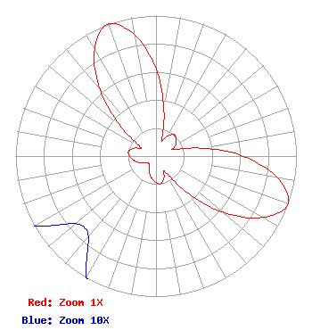 | |||||||||||||||||||||||||
| Azimuth | Ratio | Azimuth | Ratio | Azimuth | Ratio | Azimuth | Ratio | |||||||||||||||||||
| 0 | 0.620 | 10 | 0.325 | 20 | 0.125 | 30 | 0.166 | |||||||||||||||||||
| 40 | 0.199 | 50 | 0.188 | 60 | 0.163 | 70 | 0.133 | |||||||||||||||||||
| 80 | 0.325 | 90 | 0.620 | 100 | 0.875 | 110 | 1.000 | |||||||||||||||||||
| 120 | 0.875 | 130 | 0.620 | 140 | 0.325 | 150 | 0.125 | |||||||||||||||||||
| 160 | 0.166 | 170 | 0.199 | 180 | 0.188 | 190 | 0.163 | |||||||||||||||||||
| 200 | 0.133 | 210 | 0.100 | 220 | 0.075 | 230 | 0.075 | |||||||||||||||||||
| 240 | 0.100 | 250 | 0.133 | 260 | 0.163 | 270 | 0.188 | |||||||||||||||||||
| 280 | 0.199 | 290 | 0.166 | 300 | 0.125 | 310 | 0.325 | |||||||||||||||||||
| 320 | 0.620 | 330 | 0.875 | 340 | 1.000 | 350 | 0.875 | |||||||||||||||||||
Structure Registration Number 1023405 Structure Type: TOWER Registered To: URSO, PHILIP J DBA = PINE HILL ASSOCIATES Structure Address: .06 Km S Of Escoheag Hill Rd West Greenwich, RI County Name: Kent County ASR Issued: 07/08/1997 Date Built: 11/24/1983 Site Elevation: 169 m (554 ft.) Structure Height: 101 m (331 ft.) Height Overall: 107 m (351 ft.) Overall Height AMSL: 276 m (906 ft.) FAA Determination: 12/29/1988 FAA Study #: 88-ANE-205-OE FAA Circular #: 70/7460-1G Paint & Light FAA Chapters: 3, 4, 5, 9 41-36-24.0 N 71-46-23.0 W (NAD 83) 41-36-23.6 N 71-46-24.8 W (Converted to NAD 27) |
482 Harbor Drive North Indian Rocks Beach, FL 33785 Phone: 607-738-5623 Limited Liability Company | Title: President Date: 05/24/2022 Application Certifier Woodland Communications, Llc 482 Harbor Drive North Indian Rocks Beach, FL 33785 Applicant Mark Denbo Smithwick & Belendiuk, P.c. 5028 Wisconsin Avenue, N.w. Suite 301 Washington, DC 20016 Counsel | ||||||||||||||||||||||||