
FCCInfo.com
A Service of Cavell, Mertz & Associates, Inc.
(855) FCC-INFO
|
|
|
Virtual Channel 18 |
|
||||||||||||||||
|
|
Status: License Application Accepted: 06/03/2022 License Expires: 02/01/2029 File Number: -0000192903 FCC Website Links: LMS Facility Details This Application Other WDFL-LD Applications Including Superseded Applications Mailing Address Correspondence for WDFL-LD Correspondence related to application -0000192903 Service Contour - Open Street Map or USGS Map (48 dBu) Service Contour - KML / Google Earth (48 dBu) Rabbit Ears Info Search for WDFL-LD Site Location: 25-58-08.0 N 80-13-19.0 W (NAD 83) Site Location: 25-58-06.7 N 80-13-19.8 W (Converted to NAD 27) ERP: 3 kW Polarization: Circularly polarized R/C AGL: 271 m (889 ft.) R/C AMSL: 273.4 m (897 ft.) Emission Mask: Full Service Site Elevation: 2.4 m. (8 ft.) Height Overall*: 317.3 m (1041 ft.) (* As Filed In This Application, may differ from ASR Data, Below.) Directional Antenna - Antenna Make/Model: Propagation System Inc PSIVHCP4PN-11 Antenna ID: 1004061 Polarization: Circularly polarized | ||||||||||||||||||
| Antenna Data for Antenna Id: 1004061 WDFL-LD LD File: -0000192903 Propagation System Inc - PSIVHCP4PN-11 Service: LD Standard Pattern: Y | 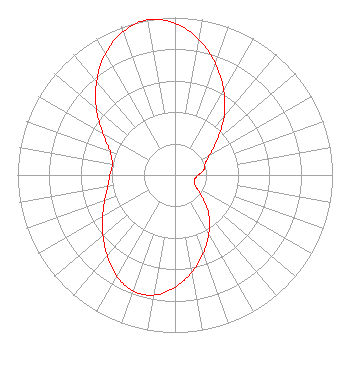 | ||||||||||||||||||
| Azimuth | Ratio | Azimuth | Ratio | Azimuth | Ratio | Azimuth | Ratio | ||||||||||||
| 0 | 0.963 | 10 | 0.874 | 20 | 0.754 | 30 | 0.619 | ||||||||||||
| 40 | 0.484 | 50 | 0.351 | 60 | 0.254 | 70 | 0.202 | ||||||||||||
| 80 | 0.186 | 90 | 0.146 | 100 | 0.130 | 110 | 0.130 | ||||||||||||
| 120 | 0.156 | 130 | 0.227 | 140 | 0.334 | 150 | 0.429 | ||||||||||||
| 160 | 0.527 | 170 | 0.625 | 180 | 0.714 | 190 | 0.775 | ||||||||||||
| 200 | 0.783 | 210 | 0.741 | 220 | 0.670 | 230 | 0.597 | ||||||||||||
| 240 | 0.531 | 250 | 0.475 | 260 | 0.434 | 270 | 0.413 | ||||||||||||
| 280 | 0.405 | 290 | 0.439 | 300 | 0.529 | 310 | 0.652 | ||||||||||||
| 320 | 0.775 | 330 | 0.887 | 340 | 0.968 | 350 | 1.000 | ||||||||||||
Structure Registration Number 1026553 [ASR Heights Differ from WDFL-LD Application] Structure Type: GTOWER Registered To: American Towers LLC Structure Address: 1255 Nw 210th Street (282698) Miami, FL County Name: Miami-Dade County ASR Issued: 10/12/2023 Date Built: 01/01/1990 Site Elevation: 1.5 m (5 ft.) Structure Height: 289.9 m (951 ft.) Height Overall: 318.2 m (1044 ft.) Overall Height AMSL: 319.7 m (1049 ft.) FAA Determination: 04/21/2023 FAA Study #: 2022-ASO-14780-OE FAA Circular #: 70/7460-1G Paint & Light FAA Chapters: 4, 6, 9 PRIOR STUDY 2021-ASO-25139-OE 25-58-08.3 N 80-13-19.2 W (NAD 83) 25-58-07.0 N 80-13-20.0 W (Converted to NAD 27) |
16280 Nw 17 St. Pembroke Pines, FL 33028 Phone: 954-812-7381 Applicant | Title: Licensee Date: 06/03/2022 Application Certifier FRANCOIS LECONTE Francois Leconte 16280 Nw 17 St. Pembroke Pines, FL 33028 Applicant GREG BEST Greg Best Consulting, Inc. 16100 Outlook Avenue Stilwell, KS 66085 Consulting Engineer FRANCOIS LECONTE Francois Leconte 16280 Nw 17 St. Pembroke Pines, FL 33028 | |||||||||||||||||