
FCCInfo.com
A Service of Cavell, Mertz & Associates, Inc.
(855) FCC-INFO
|
|
K18NP-D from 08/21/2012 |
|
|
||||||||||||||||
|
|
Status: Construction Permit Application Accepted: 06/13/2022 K18NP-D CP Expires: 09/06/2022 File Number: -0000193286 FCC Website Links: LMS Facility Details This Application Other K18NP-D Applications Including Superseded Applications Mailing Address Correspondence for K18NP-D Correspondence related to application -0000193286 Service Contour - Open Street Map or USGS Map (51 dBu) Service Contour - KML / Google Earth (51 dBu) Rabbit Ears Info Search for K18NP-D Site Location: 46-51-23.8 N 96-44-26.4 W (NAD 83) Site Location: 46-51-23.9 N 96-44-25.1 W (Converted to NAD 27) ERP: 0.1 kW Polarization: Horizontally polarized R/C AGL: 6 m (20 ft.) R/C AMSL: 284.3 m (933 ft.) Emission Mask: Simple Site Elevation: 278.3 m. (913 ft.) Height Overall*: 96 m (315 ft.) (* As Filed In This Application, may differ from ASR Data, Below.) Directional Antenna - Antenna Make/Model: SBP UPSL Antenna ID: 100733 Polarization: Horizontally polarized | ||||||||||||||||||
| Antenna Data for Antenna Id: 100733 K18NP-D LD File: -0000193286 SBP - UPSL Service: LD Standard Pattern: Y Pattern and Field Values Include a 180° Clockwise Rotation | 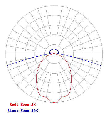 | ||||||||||||||||||
| Azimuth | Ratio | Azimuth | Ratio | Azimuth | Ratio | Azimuth | Ratio | ||||||||||||
| 0 | 0.010 | 10 | 0.010 | 20 | 0.010 | 30 | 0.010 | ||||||||||||
| 40 | 0.010 | 50 | 0.010 | 60 | 0.010 | 70 | 0.010 | ||||||||||||
| 80 | 0.010 | 90 | 0.010 | 100 | 0.048 | 110 | 0.190 | ||||||||||||
| 120 | 0.280 | 130 | 0.410 | 140 | 0.550 | 150 | 0.710 | ||||||||||||
| 160 | 0.880 | 170 | 0.917 | 180 | 1.000 | 190 | 0.917 | ||||||||||||
| 200 | 0.880 | 210 | 0.710 | 220 | 0.555 | 230 | 0.410 | ||||||||||||
| 240 | 0.280 | 250 | 0.190 | 260 | 0.048 | 270 | 0.010 | ||||||||||||
| 280 | 0.010 | 290 | 0.010 | 300 | 0.010 | 310 | 0.010 | ||||||||||||
| 320 | 0.010 | 330 | 0.010 | 340 | 0.010 | 350 | 0.010 | ||||||||||||
Structure Registration Number 1059614 Structure Type: GTOWER Registered To: American Towers LLC Structure Address: 1774 25th St. South (moorhead #2 - 050679) Moorhead, MN County Name: Clay County ASR Issued: 10/18/2017 Date Built: 01/15/1998 Site Elevation: 278.3 m (913 ft.) Structure Height: 92.4 m (303 ft.) Height Overall: 96 m (315 ft.) Overall Height AMSL: 374.3 m (1228 ft.) FAA Determination: 10/17/2017 FAA Study #: 2017-AGL-17237-OE FAA Circular #: 70/7460-1L Paint & Light FAA Chapters: 4, 8, 12 PRIOR STUDY 2014-AGL-14531-OE 46-51-23.8 N 96-44-26.4 W (NAD 83) 46-51-23.9 N 96-44-25.1 W (Converted to NAD 27) |
711 Tappen Shire Colleyville, TX 76034 Phone: 214-770-7770 Limited Liability Company | Title: Member/manager Date: 06/13/2022 Application Certifier Fidelitv, Llc 711 Tappen Shire Colleyville, TX 76034 Applicant Josh Weiss Ark Multicasting, Inc. Cedar Hill, TX 75106 CEO Susan Hansen B. W. St. Clair 2305 Vida Shaw Rd. New Iberia, LA 70563 Consultant Ari Meltzer Wiley Rein Llp 2050 M St Nw Washington, DC 20036 | |||||||||||||||||