
FCCInfo.com
A Service of Cavell, Mertz & Associates, Inc.
(855) FCC-INFO
|
|
from 10/13/2022 from 02/25/1981 |
Virtual Channel 44 |
|
||||||||||||||||||||||
|
|
Status: Construction Permit Application Accepted: 06/22/2022 WLMA CP Expires: 06/23/2025 File Number: -0000150679 FCC Website Links: LMS Facility Details This Application Other WLMA Applications Including Superseded Applications Mailing Address Correspondence for WLMA Correspondence related to application -0000150679 Service Contour - Open Street Map or USGS Map (51 dBu) Service Contour - KML / Google Earth (51 dBu) Rabbit Ears Info Search for WLMA Site Location: 40-55-59.0 N 83-22-49.0 W (NAD 83) Site Location: 40-55-58.8 N 83-22-49.3 W (Converted to NAD 27) ERP: 15 kW Polarization: Elliptically polarized Electrical Beam Tilt: 1.0 degree R/C AGL: 93.2 m (306 ft.) R/C AMSL: 345 m (1132 ft.) Emission Mask: Simple Site Elevation: 251.8 m. (826 ft.) Height Overall*: 151.9 m (498 ft.) (* As Filed In This Application, may differ from ASR Data, Below.) Directional Antenna - Antenna Make/Model: DIELECTRIC TLP-8F/VP Antenna ID: 1009690 Polarization: Elliptically polarized
| ||||||||||||||||||||||||
| Antenna Data for Antenna Id: 1009690 WLMA LD File: -0000150679 DIELECTRIC - TLP-8F/VP Service: LD Standard Pattern: N Pattern and Field Values Include a 255° Clockwise Rotation | 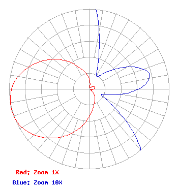 | ||||||||||||||||||||||||
| Azimuth | Ratio | Azimuth | Ratio | Azimuth | Ratio | Azimuth | Ratio | ||||||||||||||||||
| 5 | 0.101 | 15 | 0.049 | 25 | 0.023 | 35 | 0.019 | ||||||||||||||||||
| 45 | 0.028 | 55 | 0.045 | 65 | 0.064 | 75 | 0.077 | ||||||||||||||||||
| 85 | 0.071 | 95 | 0.051 | 105 | 0.028 | 115 | 0.017 | ||||||||||||||||||
| 125 | 0.035 | 135 | 0.080 | 145 | 0.125 | 155 | 0.168 | ||||||||||||||||||
| 165 | 0.224 | 175 | 0.304 | 185 | 0.409 | 195 | 0.525 | ||||||||||||||||||
| 205 | 0.640 | 215 | 0.750 | 225 | 0.849 | 235 | 0.932 | ||||||||||||||||||
| 245 | 0.987 | 255 | 1.000 | 265 | 0.983 | 275 | 0.939 | ||||||||||||||||||
| 285 | 0.850 | 295 | 0.745 | 305 | 0.634 | 315 | 0.521 | ||||||||||||||||||
| 325 | 0.405 | 335 | 0.296 | 345 | 0.223 | 355 | 0.165 | ||||||||||||||||||
Structure Registration Number 1026917 Structure Type: TOWER Registered To: OHIO, STATE OF Structure Address: 150 Ft South Of Tyson Road Carey, OH County Name: Wyandot County ASR Issued: 04/14/2014 Date Built: 09/30/1992 Site Elevation: 251.8 m (826 ft.) Structure Height: 149.7 m (491 ft.) Height Overall: 151.9 m (498 ft.) Overall Height AMSL: 403.7 m (1324 ft.) FAA Determination: 06/10/1997 FAA Study #: 97-AGL-1077-OE FAA Circular #: 70/7460-1J Paint & Light FAA Chapters: 3, 4, 5, 13 40-55-59.0 N 83-22-49.0 W (NAD 83) 40-55-58.8 N 83-22-49.3 W (Converted to NAD 27) |
629 Downard Road Zanesville, OH 43701 Phone: 301-661-9610 Corporation | Title: President Date: 06/22/2022 Application Certifier American Christian Television Services, Inc. 1844 Baty Road Lima, OH 45807 Applicant Louis R duTreil, Jr Dutreil Lundin & Rackley Inc 5212 Station Way Sarasota, FL 34233 Technical Consultant Eve K. Reed, Esq Wiley Rein Llp 1776 K Street, N.w. Washington, DC 20006 | |||||||||||||||||||||||