
FCCInfo.com
A Service of Cavell, Mertz & Associates, Inc.
(855) FCC-INFO
|
|
KPDS-LD from 02/22/2011 |
|
|
||||||||||||||||
|
|
Status: License Application Accepted: 06/22/2022 License Expires: 08/01/2029 File Number: -0000193748 FCC Website Links: LMS Facility Details This Application Other KPDS-LD Applications Including Superseded Applications Mailing Address Correspondence for KPDS-LD Correspondence related to application -0000193748 Service Contour - Open Street Map or USGS Map (48 dBu) Service Contour - KML / Google Earth (48 dBu) Rabbit Ears Info Search for KPDS-LD Site Location: 41-17-23.7 N 87-17-59.7 W (NAD 83) Site Location: 41-17-23.6 N 87-17-59.6 W (Converted to NAD 27) ERP: 3 kW Polarization: Horizontally polarized R/C AGL: 85 m (279 ft.) R/C AMSL: 288.6 m (947 ft.) Emission Mask: Full Service Site Elevation: 203.6 m. (668 ft.) Height Overall*: 91.1 m (299 ft.) (* As Filed In This Application, may differ from ASR Data, Below.) Directional Antenna - Antenna Make/Model: DIELECTRIC TLS-V-S170 Antenna ID: 1003505 Polarization: Horizontally polarized | ||||||||||||||||||
| Antenna Data for Antenna Id: 1003505 KPDS-LD LD File: -0000193748 DIELECTRIC - TLS-V-S170 Service: LD Standard Pattern: Y | 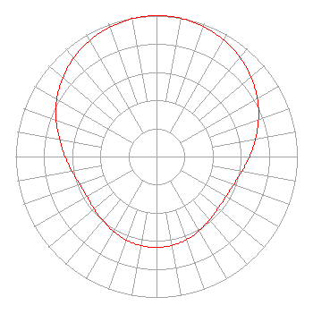 | ||||||||||||||||||
| Azimuth | Ratio | Azimuth | Ratio | Azimuth | Ratio | Azimuth | Ratio | ||||||||||||
| 0 | 1.000 | 10 | 0.996 | 20 | 0.981 | 30 | 0.955 | ||||||||||||
| 40 | 0.920 | 50 | 0.876 | 60 | 0.826 | 70 | 0.771 | ||||||||||||
| 80 | 0.714 | 90 | 0.661 | 100 | 0.615 | 110 | 0.583 | ||||||||||||
| 120 | 0.569 | 130 | 0.571 | 140 | 0.586 | 150 | 0.607 | ||||||||||||
| 160 | 0.627 | 170 | 0.640 | 180 | 0.645 | 190 | 0.641 | ||||||||||||
| 200 | 0.631 | 210 | 0.613 | 220 | 0.592 | 230 | 0.579 | ||||||||||||
| 240 | 0.570 | 250 | 0.579 | 260 | 0.610 | 270 | 0.650 | ||||||||||||
| 280 | 0.699 | 290 | 0.759 | 300 | 0.817 | 310 | 0.869 | ||||||||||||
| 320 | 0.914 | 330 | 0.951 | 340 | 0.975 | 350 | 0.993 | ||||||||||||
Structure Registration Number 1247513 Structure Type: TOWER Registered To: VB-S1 Assets, LLC Structure Address: 3074 W. 181st Ave -- 84428 Hebron, IN County Name: Lake County ASR Issued: 03/31/2022 Date Built: 03/08/2005 Site Elevation: 203.6 m (668 ft.) Structure Height: 88.4 m (290 ft.) Height Overall: 91.1 m (299 ft.) Overall Height AMSL: 294.7 m (967 ft.) FAA Determination: 05/19/2004 FAA Study #: 2004-AGL-1849-OE Paint & Light FAA Chapters: A1, H, 3, 11, 21, 23 Continue As Is OM&L = A MED-DUAL SYSTEM 41-17-23.7 N 87-17-59.7 W (NAD 83) 41-17-23.6 N 87-17-59.6 W (Converted to NAD 27) |
295 Madison Avenue, 12th Floor New York, NY 10017 Phone: 954-606-5486 Corporation | Title: Vice President Of Regulatory Affairs Date: 06/22/2022 Application Certifier Hc2 Station Group, Inc. 295 Madison Avenue, 12th Floor New York, NY 10017 Applicant RENEE ILHARDT Hc2 Broadcasting Holdings, Inc. 295 Madison Avenue, 12th Floor New York, NY 10017 VICE PRESIDENT OF REGULATORY AFFAIRS DAVID O'CONNOR Wilkinson, Barker, Knauer, Llp 1800 M Street, Nw; Suite 800n Washington, DC 20036 PARTNER MICHAEL VOGE Hc2 Broadcasting Holdings, Inc. 295 Madison Avenue, 12th Floor New York, NY 10017 DIRECTOR OF ENGINEERING OPERATIONS | |||||||||||||||||