
FCCInfo.com
A Service of Cavell, Mertz & Associates, Inc.
(855) FCC-INFO
|
|
K30QY-D from 10/02/2012 |
|
|
||||||||||||||||
|
|
Status: License Application Accepted: 07/06/2022 License Expires: 04/01/2030 File Number: -0000194532 FCC Website Links: LMS Facility Details This Application Other K30QY-D Applications Including Superseded Applications Mailing Address Correspondence for K30QY-D Correspondence related to application -0000194532 Service Contour - Open Street Map or USGS Map (51 dBu) Service Contour - KML / Google Earth (51 dBu) Rabbit Ears Info Search for K30QY-D Site Location: 43-29-18.0 N 93-14-13.0 W (NAD 83) Site Location: 43-29-18.2 N 93-14-12.3 W (Converted to NAD 27) ERP: 0.8 kW Polarization: Elliptically polarized R/C AGL: 12.2 m (40 ft.) R/C AMSL: 393.2 m (1290 ft.) Emission Mask: Simple Site Elevation: 381 m. (1250 ft.) Height Overall*: 98.8 m (324 ft.) (* As Filed In This Application, may differ from ASR Data, Below.) Directional Antenna - Antenna Make/Model: Kathrein 750 10325 1x Antenna ID: 1009080 Polarization: Elliptically polarized | ||||||||||||||||||
| Antenna Data for Antenna Id: 1009080 K30QY-D LD File: -0000194532 Kathrein - 750 10325 1x Service: LD Standard Pattern: Y Pattern and Field Values Include a 110° Clockwise Rotation | 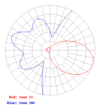 | ||||||||||||||||||
| Azimuth | Ratio | Azimuth | Ratio | Azimuth | Ratio | Azimuth | Ratio | ||||||||||||
| 0 | 0.042 | 10 | 0.029 | 20 | 0.056 | 30 | 0.107 | ||||||||||||
| 40 | 0.179 | 50 | 0.277 | 60 | 0.404 | 70 | 0.556 | ||||||||||||
| 80 | 0.719 | 90 | 0.866 | 100 | 0.968 | 110 | 1.000 | ||||||||||||
| 120 | 0.953 | 130 | 0.838 | 140 | 0.685 | 150 | 0.524 | ||||||||||||
| 160 | 0.376 | 170 | 0.255 | 180 | 0.163 | 190 | 0.095 | ||||||||||||
| 200 | 0.048 | 210 | 0.029 | 220 | 0.046 | 230 | 0.066 | ||||||||||||
| 240 | 0.075 | 250 | 0.070 | 260 | 0.060 | 270 | 0.066 | ||||||||||||
| 280 | 0.083 | 290 | 0.090 | 300 | 0.079 | 310 | 0.063 | ||||||||||||
| 320 | 0.062 | 330 | 0.072 | 340 | 0.074 | 350 | 0.063 | ||||||||||||
Structure Registration Number 1017894 Structure Type: TOWER Registered To: Vertical Bridge S3 Assets, LLC Structure Address: 8 Toon Rzow Worth Cty Northwood, IA County Name: Worth County ASR Issued: 03/19/2018 Date Built: 08/10/1994 Site Elevation: 381 m (1250 ft.) Structure Height: 98.8 m (324 ft.) Height Overall: 98.8 m (324 ft.) Overall Height AMSL: 479.8 m (1574 ft.) FAA Determination: 08/05/1987 FAA Study #: 87-ACE-0583-OE FAA Circular #: 70/7460-1G Paint & Light FAA Chapters: 3, 4, 5, 9 43-29-18.0 N 93-14-13.0 W (NAD 83) 43-29-18.2 N 93-14-12.3 W (Converted to NAD 27) |
4370 Peachtree Road, Ne Atlanta, GA 30319 Phone: 202-750-1585 Limited Liability Company | Title: Assistant Secretary Date: 07/06/2022 Application Certifier Gray Television Licensee, Llc 4370 Peachtree Road, Ne Atlanta, GA 30319 Applicant Joseph M. Davis, P.E. Chesapeake Rf Consultants, Llc 207 Old Dominion Road Yorktown, VA 23692 Consulting Engineer Joan Stewart Wiley Rein Llp 2050 M Street Nw Washington, DC 20036 | |||||||||||||||||