
FCCInfo.com
A Service of Cavell, Mertz & Associates, Inc.
(855) FCC-INFO
|
|
from 07/22/2022 from 07/21/2022 from 02/20/2015 from 05/15/2002 |
|
|
||||||||||||||||
|
|
Status: License Application Accepted: 07/11/2022 License Expires: 02/01/2029 File Number: -0000194725 FCC Website Links: LMS Facility Details This Application Other WHMR-LD Applications Including Superseded Applications Mailing Address Correspondence for WHMR-LD Correspondence related to application -0000194725 Service Contour - Open Street Map or USGS Map (51 dBu) Service Contour - KML / Google Earth (51 dBu) Rabbit Ears Info Search for WHMR-LD Site Location: 25-32-23.9 N 80-28-06.4 W (NAD 83) Site Location: 25-32-22.5 N 80-28-07.2 W (Converted to NAD 27) ERP: 9 kW Polarization: Horizontally polarized Electrical Beam Tilt: 0.5 degrees R/C AGL: 175 m (574 ft.) R/C AMSL: 177.1 m (581 ft.) Emission Mask: Stringent Site Elevation: 2.1 m. (7 ft.) Height Overall*: 561.4 m (1842 ft.) (* As Filed In This Application, may differ from ASR Data, Below.) Directional Antenna - Antenna Make/Model: Kathrein 2X1 75010210 Antenna ID: 1009760 Polarization: Horizontally polarized | ||||||||||||||||||
| Antenna Data for Antenna Id: 1009760 WHMR-LD LD File: -0000194725 Kathrein - 2X1 75010210 Service: LD Standard Pattern: N Pattern and Field Values Include a 180° Clockwise Rotation | 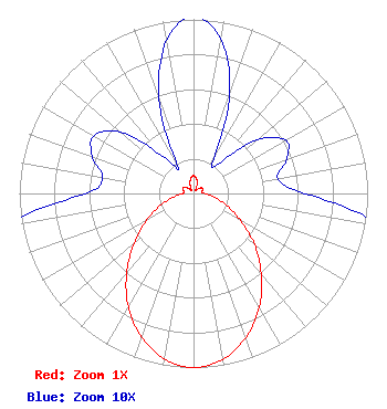 | ||||||||||||||||||
| Azimuth | Ratio | Azimuth | Ratio | Azimuth | Ratio | Azimuth | Ratio | ||||||||||||
| 0 | 0.102 | 10 | 0.090 | 20 | 0.061 | 30 | 0.023 | ||||||||||||
| 40 | 0.022 | 50 | 0.048 | 60 | 0.061 | 70 | 0.057 | ||||||||||||
| 80 | 0.049 | 90 | 0.064 | 100 | 0.117 | 110 | 0.201 | ||||||||||||
| 120 | 0.312 | 130 | 0.457 | 140 | 0.605 | 150 | 0.754 | ||||||||||||
| 160 | 0.880 | 170 | 0.968 | 180 | 1.000 | 190 | 0.966 | ||||||||||||
| 200 | 0.875 | 210 | 0.749 | 220 | 0.598 | 230 | 0.445 | ||||||||||||
| 240 | 0.313 | 250 | 0.201 | 260 | 0.116 | 270 | 0.062 | ||||||||||||
| 280 | 0.053 | 290 | 0.062 | 300 | 0.066 | 310 | 0.055 | ||||||||||||
| 320 | 0.028 | 330 | 0.018 | 340 | 0.058 | 350 | 0.089 | ||||||||||||
Structure Registration Number 1024985 Structure Type: GTOWER Registered To: American Towers, LLC Structure Address: 17107 Sw 248th Street (282684) Homestead, FL County Name: Miami-Dade County ASR Issued: 07/08/2019 Date Built: 08/21/1993 Site Elevation: 2.1 m (7 ft.) Structure Height: 538.6 m (1767 ft.) Height Overall: 561.4 m (1842 ft.) Overall Height AMSL: 563.5 m (1849 ft.) FAA Determination: 07/02/2019 FAA Study #: 2018-ASO-10925-OE FAA Circular #: 70/7460-1K Paint & Light FAA Chapters: 4, 7, 12 PRIOR STUDY 2014-ASO-12387-OE 25-32-23.9 N 80-28-06.4 W (NAD 83) 25-32-22.5 N 80-28-07.2 W (Converted to NAD 27) |
38955 Hills Tech Dr. Farmington Hills, MI 48331 Phone: 248-536-0776 Limited Liability Company | Title: Manager Date: 07/11/2022 Application Certifier Wkiz Uhf Tv Llc 29793 Ruby Ranch Road Po Box 1471 Evergreen, CO 80439 Applicant Erik C Swanson, PE Hatfield & Dawson 9500 Greenwood Ave N Seattle, WA 98103 Consulting Engineer James Talens James Talens, Attorney 6017 Woodley Road Mclean, VA 22101 Counsel | |||||||||||||||||