
FCCInfo.com
A Service of Cavell, Mertz & Associates, Inc.
(855) FCC-INFO
|
|
K21JS-D from 04/06/2012 K21JS-D from 10/19/1993 K21JS-D from 09/13/1993 K21JS-D from 09/02/1993 |
|
|
||||||||||||||||
|
|
Status: License Application Accepted: 07/11/2022 License Expires: 06/01/2021 File Number: -0000194711 FCC Website Links: LMS Facility Details This Application Other K21JS-D Applications Including Superseded Applications Mailing Address Correspondence for K21JS-D Correspondence related to application -0000194711 Service Contour - Open Street Map or USGS Map (51 dBu) Service Contour - KML / Google Earth (51 dBu) Rabbit Ears Info Search for K21JS-D Site Location: 36-14-35.4 N 93-13-14.7 W (NAD 83) Site Location: 36-14-35.1 N 93-13-14.1 W (Converted to NAD 27) ERP: 0.075 kW Polarization: Horizontally polarized R/C AGL: 34 m (112 ft.) R/C AMSL: 633.5 m (2078 ft.) Emission Mask: Stringent Site Elevation: 599.5 m. (1967 ft.) Height Overall*: 60.4 m (198 ft.) (* As Filed In This Application, may differ from ASR Data, Below.) Directional Antenna - Antenna Make/Model: Jampro JA/LS-AF-8 Antenna ID: 19359 Polarization: Horizontally polarized | ||||||||||||||||||
| Antenna Data for Antenna Id: 19359 K21JS-D LD File: -0000194711 Jampro - JA/LS-AF-8 Service: LD Standard Pattern: Y Pattern and Field Values Include a 90° Clockwise Rotation | 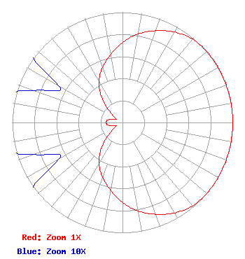 | ||||||||||||||||||
| Azimuth | Ratio | Azimuth | Ratio | Azimuth | Ratio | Azimuth | Ratio | ||||||||||||
| 0 | 0.725 | 10 | 0.815 | 20 | 0.886 | 30 | 0.946 | ||||||||||||
| 40 | 0.988 | 50 | 1.000 | 60 | 1.000 | 70 | 1.000 | ||||||||||||
| 80 | 1.000 | 90 | 1.000 | 100 | 1.000 | 110 | 1.000 | ||||||||||||
| 120 | 1.000 | 130 | 1.000 | 140 | 0.988 | 150 | 0.946 | ||||||||||||
| 160 | 0.886 | 170 | 0.815 | 180 | 0.725 | 190 | 0.624 | ||||||||||||
| 200 | 0.529 | 210 | 0.428 | 220 | 0.293 | 230 | 0.146 | ||||||||||||
| 240 | 0.067 | 250 | 0.085 | 260 | 0.136 | 270 | 0.147 | ||||||||||||
| 280 | 0.136 | 290 | 0.085 | 300 | 0.067 | 310 | 0.146 | ||||||||||||
| 320 | 0.293 | 330 | 0.428 | 340 | 0.529 | 350 | 0.624 | ||||||||||||
Structure Registration Number 1256044 Structure Type: TOWER Registered To: Cellco Partnership Structure Address: 4048 Pilot Knob Drive Harrison, AR County Name: Boone County ASR Issued: 02/04/2019 Date Built: 03/15/2007 Site Elevation: 599.5 m (1967 ft.) Structure Height: 57.9 m (190 ft.) Height Overall: 60.4 m (198 ft.) Overall Height AMSL: 659.9 m (2165 ft.) FAA Determination: 10/20/2006 FAA Study #: 2006-ASW-6331-OE Paint & Light FAA Chapters: NONE Removed expiration date from determination. Scenario 1./jjs/case#635066 36-14-35.4 N 93-13-14.7 W (NAD 83) 36-14-35.1 N 93-13-14.1 W (Converted to NAD 27) |
Hurst, TX 76054 Phone: 214-770-7770 Corporation | Title: Ceo Date: 07/11/2022 Application Certifier EDGE SPECTRUM, INC. Edge Spectrum, Inc. Hurst, TX 76054 Applicant Susan Hansen B.w. St. Clair 2305 Vida Shaw Rd. New Iberia, LA 70563 Consultant Ari Meltzer Wiley Rein Llp 2050 M Street, Nw Washington, DC 20036 Josh Weiss Ark Multicasting, Inc. Cedar Hill, TX 75106 CEO Randy Weiss Edge Spectrum, Inc. Hurst, TX 76054 CEO Caleb Weiss Ark Multicasting, Inc. Cedar Hill, TX 75106 President | |||||||||||||||||