
FCCInfo.com
A Service of Cavell, Mertz & Associates, Inc.
(855) FCC-INFO
|
|
WDNM-LD from 12/02/2006 WDNM-LD from 11/03/2005 WDNM-LD from 04/20/2005 WDNM-LD from 06/15/1999 WDNM-LD from 12/22/2000 WDNM-LD from 07/28/1997 WDNM-LD from 04/26/1995 |
|
|
||||||||||||||||
|
|
Status: License Application Accepted: 07/15/2022 License Expires: 08/01/2029 File Number: -0000195049 FCC Website Links: LMS Facility Details This Application Other WDNM-LD Applications Including Superseded Applications Mailing Address Correspondence for WDNM-LD Correspondence related to application -0000195049 Service Contour - Open Street Map or USGS Map (51 dBu) Service Contour - KML / Google Earth (51 dBu) Rabbit Ears Info Search for WDNM-LD Site Location: 35-10-29.0 N 89-50-43.0 W (NAD 83) Site Location: 35-10-28.7 N 89-50-42.7 W (Converted to NAD 27) ERP: 15 kW Polarization: Horizontally polarized R/C AGL: 277 m (909 ft.) R/C AMSL: 355 m (1165 ft.) Emission Mask: Full Service Site Elevation: 78 m. (256 ft.) Height Overall*: 325.8 m (1069 ft.) (* As Filed In This Application, may differ from ASR Data, Below.) Directional Antenna - Antenna Make/Model: Systems With Reliability Inc. SWEDL16NCN/22-H Antenna ID: 1009787 Polarization: Horizontally polarized | ||||||||||||||||||
| Antenna Data for Antenna Id: 1009787 WDNM-LD LD File: -0000195049 Systems With Reliability Inc. - SWEDL16NCN/22-H Service: LD Standard Pattern: N Pattern and Field Values Include a 295° Clockwise Rotation | 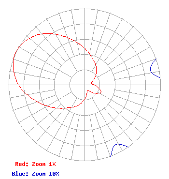 | ||||||||||||||||||
| Azimuth | Ratio | Azimuth | Ratio | Azimuth | Ratio | Azimuth | Ratio | ||||||||||||
| 5 | 0.440 | 15 | 0.370 | 25 | 0.320 | 35 | 0.270 | ||||||||||||
| 45 | 0.220 | 55 | 0.170 | 65 | 0.120 | 75 | 0.090 | ||||||||||||
| 85 | 0.100 | 95 | 0.150 | 105 | 0.200 | 115 | 0.240 | ||||||||||||
| 125 | 0.200 | 135 | 0.150 | 145 | 0.100 | 155 | 0.090 | ||||||||||||
| 165 | 0.120 | 175 | 0.170 | 185 | 0.220 | 195 | 0.270 | ||||||||||||
| 205 | 0.320 | 215 | 0.370 | 225 | 0.440 | 235 | 0.520 | ||||||||||||
| 245 | 0.610 | 255 | 0.710 | 265 | 0.820 | 275 | 0.910 | ||||||||||||
| 285 | 0.970 | 295 | 1.000 | 305 | 0.970 | 315 | 0.910 | ||||||||||||
| 325 | 0.820 | 335 | 0.710 | 345 | 0.610 | 355 | 0.520 | ||||||||||||
Structure Registration Number 1039554 Structure Type: GTOWER Registered To: American Towers LLC Structure Address: 6555 Raleigh La Grange Rd (#207708) Memphis, TN County Name: Shelby County ASR Issued: 07/10/2021 Date Built: 11/18/2010 Site Elevation: 78 m (256 ft.) Structure Height: 306.5 m (1006 ft.) Height Overall: 325.8 m (1069 ft.) Overall Height AMSL: 403.8 m (1325 ft.) FAA Determination: 07/08/2021 FAA Study #: 2021-ASO-24772-OE FAA Circular #: 70/7460-1M Paint & Light FAA Chapters: 4, 9, 15 PRIOR STUDY 2017-ASO-18906-OE 35-10-29.0 N 89-50-43.0 W (NAD 83) 35-10-28.7 N 89-50-42.7 W (Converted to NAD 27) |
3901 Highway 121, South Bedford, TX 76021 Phone: 817-571-1229 Applicant | Title: Manager Date: 07/15/2022 Application Certifier WORD OF GOD FELLOWSHIP, INC. Word Of God Fellowship, Inc. 3901 Highway 121, South Bedford, TX 76021 Applicant RICHARD C GOETZ R & L Media Systems 135 N Country Club Dr Hendersonville, TN 37075 BROADCAST CONSULTANT Robert L. Olender, Esq. Koerner & Olender P.c. 7020 Richard Drive Bethesda, MD 20817 LEGAL REPRESENTATIVE | |||||||||||||||||