
FCCInfo.com
A Service of Cavell, Mertz & Associates, Inc.
(855) FCC-INFO
|
|
NEW from 09/13/2022 |
|
|
||||||||||||||||
|
|
Status: Construction Permit Application Accepted: 07/22/2022 KKAB CP Expires: 09/13/2025 File Number: -0000195585 FCC Website Links: LMS Facility Details This Application Other KKAB Applications Including Superseded Applications Mailing Address Correspondence for KKAB Correspondence related to application -0000195585 Service Contour - Open Street Map or USGS Map (36 dBu) Service Contour - KML / Google Earth (36 dBu) Public Inspection Files Rabbit Ears Info Search for KKAB Site Location: 32-46-40.8 N 108-18-44.2 W (NAD 83) Site Location: 32-46-40.5 N 108-18-42.0 W (Converted to NAD 27) ERP: 2.8 kW Polarization: Horizontally polarized HAAT: 216 m (709 ft.) R/C AGL: 47.2 m (155 ft.) R/C AMSL: 2075.6 m (6810 ft.) Site Elevation: 2028.4 m. (6655 ft.) Height Overall*: 60 m (197 ft.) (* As Filed In This Application, may differ from ASR Data, Below.) Directional Antenna - Antenna Make/Model: Scala DRV-1/1 Antenna ID: 1003223 Polarization: Horizontally polarized | ||||||||||||||||||
| Antenna Data for Antenna Id: 1003223 KKAB DT File: -0000195585 Scala - DRV-1/1 Service: DT Standard Pattern: Y Pattern and Field Values Include a 115° Clockwise Rotation | 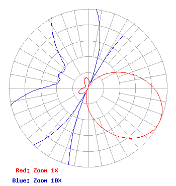 | ||||||||||||||||||
| Azimuth | Ratio | Azimuth | Ratio | Azimuth | Ratio | Azimuth | Ratio | ||||||||||||
| 5 | 0.104 | 15 | 0.058 | 25 | 0.008 | 35 | 0.092 | ||||||||||||
| 45 | 0.197 | 55 | 0.323 | 65 | 0.465 | 75 | 0.616 | ||||||||||||
| 85 | 0.763 | 95 | 0.887 | 105 | 0.970 | 115 | 1.000 | ||||||||||||
| 125 | 0.970 | 135 | 0.887 | 145 | 0.763 | 155 | 0.616 | ||||||||||||
| 165 | 0.465 | 175 | 0.323 | 185 | 0.197 | 195 | 0.092 | ||||||||||||
| 205 | 0.008 | 215 | 0.058 | 225 | 0.104 | 235 | 0.127 | ||||||||||||
| 245 | 0.128 | 255 | 0.108 | 265 | 0.075 | 275 | 0.044 | ||||||||||||
| 285 | 0.037 | 295 | 0.041 | 305 | 0.037 | 315 | 0.043 | ||||||||||||
| 325 | 0.075 | 335 | 0.108 | 345 | 0.128 | 355 | 0.127 | ||||||||||||
Structure Registration Number 1054828 Structure Type: TOWER Registered To: New Cingular Wireless PCS, LLC Structure Address: 100 Turner Road Silver City, NM County Name: Grant County ASR Issued: 04/04/2011 Date Built: 06/22/2010 Site Elevation: 2028.4 m (6655 ft.) Structure Height: 55.8 m (183 ft.) Height Overall: 60 m (197 ft.) Overall Height AMSL: 2088.4 m (6852 ft.) FAA Determination: 03/28/2011 FAA Study #: 2011-ASW-1741-OE Paint & Light FAA Chapters: NONE PRIOR STUDY 2002-ASW-1884-OE 32-46-40.8 N 108-18-44.2 W (NAD 83) 32-46-40.5 N 108-18-42.0 W (Converted to NAD 27) |
26 North Halsted Street Chicago, IL 60661 Phone: 312-705-2600 Corporation | Title: Director, President, Secretary And Treasurer Date: 07/22/2022 Application Certifier Tv-49, Inc. 26 North Halsted Street Chicago, IL 60661 Applicant Matthew S. DelNero Covington & Burling Llp One Citycenter 850 Tenth Street, Nw Washington, DC 20001 Legal Counsel Louis R duTreil, Jr Dutreil Lundin & Rackley Inc 5212 Station Way Sarasota, FL 34233 Technical Consultant | |||||||||||||||||