|
WLKY(DT)
Call Sign History
WLKY from 06/18/2013
WLKY-TV from 06/19/1997
WLKY from 03/31/1994
WLKY-TV from 05/01/1979
WLKY from ???
|
Channel 14DT
Virtual Channel 32
| 
|
Louisville, KY
|
|
| WLKY Service: DT - Digital TV (ATSC3 Station) |
 |
| Channel: 14 Zone: 1 |
| Louisville, Kentucky |
| Nielsen DMA™: Louisville |
| Network: CBS, MeTV |
| Virtual Channel: 32 |
| DTV TSID: 1253 |
| Facility ID: 53939 | | FRN: 0002538445 |
Status: LIC
Application Accepted: 08/03/2022
License Expires: 08/01/2029
File Number: 0000196798
FCC Website Links:
LMS Facility Details
This Application
Other WLKY Applications
Including Superseded Applications
Service Contour - Open Street Map or USGS Map (41 dBu)
Service Contour - KML / Google Earth (41 dBu)
Public Inspection Files
Rabbit Ears Info Search for WLKY
Site Location: 38-22-08.4 N 85-49-47.6 W (NAD 83)
Site Location: 38-22-08.2 N 85-49-47.7 W (Converted to NAD 27)
ERP: 710 kW
Polarization: Horizontally polarized
HAAT: 391.6 m (1285 ft.)
Electrical Beam Tilt: 1.0 degree
R/C AGL: 283 m (928 ft.)
R/C AMSL: 582.6 m (1911 ft.)
Site Elevation: 299.6 m. (983 ft.)
Height Overall*: 292.9 m (961 ft.)
(* As Filed In This Application, may differ from ASR Data, Below.)
Directional Antenna - Antenna Make/Model: DIELECTRIC TUM30-AP-S4-14/56H-R-2-T
Antenna ID: 1009869
Polarization: Horizontally polarized
|
Antenna Data for Antenna Id: 1009869
WLKY DT File: -0000196798
DIELECTRIC - TUM30-AP-S4-14/56H-R-2-T
Service: DT
Standard Pattern: N
|
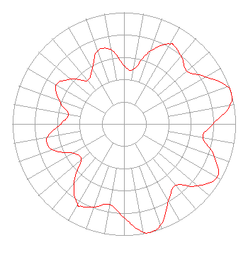 |
| Azimuth | Ratio | Azimuth | Ratio | Azimuth | Ratio | Azimuth | Ratio |
| 0 | 0.521 | 10 | 0.497 | 20 | 0.697 | 30 | 0.828 |
| 32 | 0.833 | 40 | 0.792 | 50 | 0.737 | 60 | 0.843 |
| 70 | 0.983 | 74 | 1.000 | 80 | 0.965 | 90 | 0.795 |
| 100 | 0.718 | 110 | 0.864 | 120 | 0.962 | 130 | 0.864 |
| 140 | 0.720 | 150 | 0.798 | 160 | 0.965 | 166 | 0.999 |
| 170 | 0.981 | 180 | 0.839 | 190 | 0.734 | 200 | 0.792 |
| 208 | 0.834 | 210 | 0.830 | 220 | 0.700 | 230 | 0.501 |
| 240 | 0.525 | 250 | 0.679 | 256 | 0.711 | 260 | 0.694 |
| 270 | 0.565 | 280 | 0.504 | 290 | 0.621 | 300 | 0.699 |
| 310 | 0.623 | 320 | 0.509 | 330 | 0.568 | 340 | 0.694 |
| 350 | 0.677 |
Structure Information
Structure Registration Number 1230057
Structure Type: GTOWER
Registered To:
P & B Towers LLC
Structure Address:
7601 N. Skyline Drive
New Albany, IN
County Name: Floyd County
ASR Issued: 03/10/2015
Date Built: 03/11/2015
Site Elevation: 299.6 m (983 ft.)
Structure Height: 274.3 m (900 ft.)
Height Overall: 292.9 m (961 ft.)
Overall Height AMSL: 592.5 m (1944 ft.)
FAA Determination: 02/24/2015
FAA Study #: 2015-AGL-2404-OE
FAA Circular #: 70/7460-1K
Paint & Light FAA Chapters: 4, 9, 12
PRIOR STUDY 2015-AGL-31-OE. FAA CHAPTERS 4,9,12 70/7460-1K WITH BIRD DEVIATION SPECIAL CONDITION.
38-22-08.4 N 85-49-47.6 W (NAD 83)
38-22-08.2 N 85-49-47.7 W
(Converted to NAD 27)
|
WLKY(DT) Licensee Information
Hearst Properties Inc.
Raleigh, NC 27602
Phone: 919-839-0300
Corporation | 0000196798 Applicant Information
Jordan M. Wertlieb
Title: President
Date: 08/03/2022
Application Certifier
Hearst Properties Inc.
Raleigh, NC 27602
Applicant
Coe W. Ramsey
Brooks, Pierce Et Al.
150 Fayetteville Street
Suite 1700
Raleigh, NC 27601
|
Associated Land Mobile Licenses
|
| | BLP00932 |
Broadcast Auxiliary Low Power |
| | BLP00945 |
Broadcast Auxiliary Low Power |
| | BLP01167 |
Broadcast Auxiliary Low Power |
| | BLQ392 |
Broadcast Auxiliary Low Power |
| | KEH549 |
Broadcast Auxiliary Remote Pickup |
| | KEH550 |
Broadcast Auxiliary Remote Pickup |
| | KVY942 |
Broadcast Auxiliary Remote Pickup |
| | KVY943 |
Broadcast Auxiliary Remote Pickup |
| Associated Microwave Licenses
|
| | KC24543 |
TV Pickup |
| | KP2967 |
TV Pickup |
| | KX6238 |
TV Pickup |
| | WLG229 |
7 GHz TV Intercity Relay |
| | WLG388 |
7 GHz TV Intercity Relay |
| | KTR80 |
7 GHz TV Studio Transmitter Link |
| | WLG235 |
7 GHz TV Studio Transmitter Link |
| | WBM709 |
13 GHz TV Intercity Relay |
| | WLQ862 |
13 GHz TV Intercity Relay |
|
