
FCCInfo.com
A Service of Cavell, Mertz & Associates, Inc.
(855) FCC-INFO
|
|
|
|
|
||||||||||||||||
|
|
Status: License Application Accepted: 07/28/2022 License Expires: 08/01/2029 File Number: -0000195938 FCC Website Links: LMS Facility Details This Application Other W22FH-D Applications Including Superseded Applications Mailing Address Correspondence for W22FH-D Correspondence related to application -0000195938 Service Contour - Open Street Map or USGS Map (51 dBu) Service Contour - KML / Google Earth (51 dBu) Rabbit Ears Info Search for W22FH-D Site Location: 41-04-04.7 N 84-59-35.3 W (NAD 83) Site Location: 41-04-04.5 N 84-59-35.4 W (Converted to NAD 27) ERP: 0.1 kW Polarization: Horizontally polarized R/C AGL: 6 m (20 ft.) R/C AMSL: 240.1 m (788 ft.) Emission Mask: Simple Site Elevation: 234.1 m. (768 ft.) Height Overall*: 59.7 m (196 ft.) (* As Filed In This Application, may differ from ASR Data, Below.) Directional Antenna - Antenna Make/Model: SBP UPSL Antenna ID: 100733 Polarization: Horizontally polarized | ||||||||||||||||||
| Antenna Data for Antenna Id: 100733 W22FH-D LD File: -0000195938 SBP - UPSL Service: LD Standard Pattern: Y Pattern and Field Values Include a 270° Clockwise Rotation | 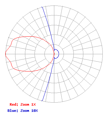 | ||||||||||||||||||
| Azimuth | Ratio | Azimuth | Ratio | Azimuth | Ratio | Azimuth | Ratio | ||||||||||||
| 0 | 0.010 | 10 | 0.010 | 20 | 0.010 | 30 | 0.010 | ||||||||||||
| 40 | 0.010 | 50 | 0.010 | 60 | 0.010 | 70 | 0.010 | ||||||||||||
| 80 | 0.010 | 90 | 0.010 | 100 | 0.010 | 110 | 0.010 | ||||||||||||
| 120 | 0.010 | 130 | 0.010 | 140 | 0.010 | 150 | 0.010 | ||||||||||||
| 160 | 0.010 | 170 | 0.010 | 180 | 0.010 | 190 | 0.048 | ||||||||||||
| 200 | 0.190 | 210 | 0.280 | 220 | 0.410 | 230 | 0.550 | ||||||||||||
| 240 | 0.710 | 250 | 0.880 | 260 | 0.917 | 270 | 1.000 | ||||||||||||
| 280 | 0.917 | 290 | 0.880 | 300 | 0.710 | 310 | 0.555 | ||||||||||||
| 320 | 0.410 | 330 | 0.280 | 340 | 0.190 | 350 | 0.048 | ||||||||||||
Structure Registration Number 1053037 Structure Type: LTOWER Registered To: American Towers LLC Structure Address: 2110 Mcconnell Dr. (91619) New Haven, IN County Name: Allen County ASR Issued: 03/19/2024 Date Built: 08/28/1998 Site Elevation: 234.1 m (768 ft.) Structure Height: 57 m (187 ft.) Height Overall: 59.7 m (196 ft.) Overall Height AMSL: 293.8 m (964 ft.) FAA Determination: 03/17/2023 FAA Study #: 2022-AGL-10757-OE Paint & Light FAA Chapters: NONE PRIOR STUDY 2010-AGL-2326-OE 41-04-04.7 N 84-59-35.3 W (NAD 83) 41-04-04.5 N 84-59-35.4 W (Converted to NAD 27) |
Hurst, TX 76054 Phone: 972-291-3750 Limited Liability Company | Title: Ceo Date: 07/28/2022 Application Certifier EICB-TV EAST, LLC Eicb-tv East, Llc Hurst, TX 76054 Applicant Susan Hansen B. W. St. Clair 2305 Vida Shaw Rd New Iberia, LA 70563 Consultant Ari Meltzer Wiley Rein Llp 2050 M Street Nw Washington, DC 20036 Randy Weiss Eicb-tv East, Llc Hurst, TX 76054 Member/Manager Josh Weiss Ark Multicasting, Inc Cedar Hill, TX 75106 CEO Caleb Weiss Ark Multicasting, Inc. Cedar Hill, TX 75106 | |||||||||||||||||