
FCCInfo.com
A Service of Cavell, Mertz & Associates, Inc.
(855) FCC-INFO
|
|
WJNK-LD from 06/30/1997 WJNK-LD from 04/26/1989 WJNK-LD from 01/10/1989 WJNK-LD from 06/25/1986 |
|
|
||||||||||||||||
|
|
Status: License Application Accepted: 08/09/2022 License Expires: 08/01/2029 File Number: -0000197213 FCC Website Links: LMS Facility Details This Application Other WJNK-LD Applications Including Superseded Applications Mailing Address Correspondence for WJNK-LD Correspondence related to application -0000197213 Service Contour - Open Street Map or USGS Map (51 dBu) Service Contour - KML / Google Earth (51 dBu) Rabbit Ears Info Search for WJNK-LD Site Location: 36-16-04.9 N 86-47-44.7 W (NAD 83) Site Location: 36-16-04.7 N 86-47-44.7 W (Converted to NAD 27) ERP: 15 kW Polarization: Elliptically polarized R/C AGL: 192 m (630 ft.) R/C AMSL: 423.7 m (1390 ft.) Emission Mask: Full Service Site Elevation: 231.7 m. (760 ft.) Height Overall*: 392.9 m (1289 ft.) (* As Filed In This Application, may differ from ASR Data, Below.) Directional Antenna - Antenna Make/Model: DIELECTRIC DLP-12B/VP Antenna ID: 1009900 Polarization: Elliptically polarized | ||||||||||||||||||
| Antenna Data for Antenna Id: 1009900 WJNK-LD LD File: -0000197213 DIELECTRIC - DLP-12B/VP Service: LD Standard Pattern: N | 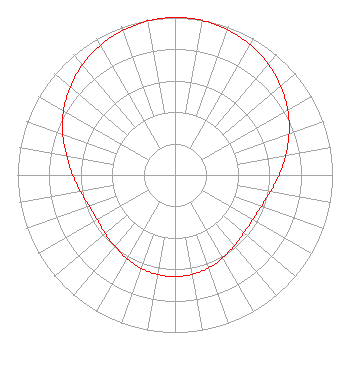 | ||||||||||||||||||
| Azimuth | Ratio | Azimuth | Ratio | Azimuth | Ratio | Azimuth | Ratio | ||||||||||||
| 0 | 1.000 | 10 | 0.996 | 20 | 0.981 | 30 | 0.955 | ||||||||||||
| 40 | 0.920 | 50 | 0.876 | 60 | 0.826 | 70 | 0.771 | ||||||||||||
| 80 | 0.714 | 90 | 0.661 | 100 | 0.615 | 110 | 0.583 | ||||||||||||
| 120 | 0.569 | 130 | 0.571 | 140 | 0.586 | 150 | 0.607 | ||||||||||||
| 160 | 0.627 | 170 | 0.640 | 180 | 0.645 | 190 | 0.641 | ||||||||||||
| 200 | 0.631 | 210 | 0.613 | 220 | 0.592 | 230 | 0.579 | ||||||||||||
| 240 | 0.570 | 250 | 0.579 | 260 | 0.610 | 270 | 0.650 | ||||||||||||
| 280 | 0.699 | 290 | 0.759 | 300 | 0.817 | 310 | 0.869 | ||||||||||||
| 320 | 0.914 | 330 | 0.951 | 340 | 0.975 | 350 | 0.993 | ||||||||||||
Structure Registration Number 1233975 Structure Type: GTOWER Registered To: American Towers LLC Structure Address: Nashville, Tn Nashville, TN County Name: Davidson County ASR Issued: 05/16/2017 Date Built: 03/15/2002 Site Elevation: 231.7 m (760 ft.) Structure Height: 352.9 m (1158 ft.) Height Overall: 392.9 m (1289 ft.) Overall Height AMSL: 624.6 m (2049 ft.) FAA Study #: 02-ASO-2205-OE FAA Circular #: Paint & Light FAA Chapters: A1, B, E, H, 3, 8, 17, 21, 23 FAA Study 2002-ASO-2205-OE requires Dual-red and high intensity white. 36-16-04.9 N 86-47-44.7 W (NAD 83) 36-16-04.7 N 86-47-44.7 W (Converted to NAD 27) |
Hurst, TX 76054 Phone: 214-770-7770 Corporation | Title: Ceo Date: 08/09/2022 Application Certifier EDGE SPECTRUM, INC. Edge Spectrum, Inc. Hurst, TX 76054 Applicant Susan Hansen B. W. St. Clair 2305 Vida Shaw Rd. New Iberia, LA 70563 Consultant Randy Weiss Edge Spectrum, Inc. Hurst, TX 76054 CEO Caleb Weiss Ark Multicasting, Inc. Cedar Hill, TX 75106 President | |||||||||||||||||
