
FCCInfo.com
A Service of Cavell, Mertz & Associates, Inc.
(855) FCC-INFO
|
|
KMTW from 10/09/1998 KMTW from 06/27/1997 |
Virtual Channel 36 |  |
|
||||||||||||||||
|
|
Repacking Information: No changes Status: License Application Accepted: 10/03/2022 License Expires: 06/01/2022 File Number: -0000201733 FCC Website Links: LMS Facility Details This Application Other KMTW Applications Including Superseded Applications Mailing Address Correspondence for KMTW Correspondence related to application -0000201733 Service Contour - Open Street Map or USGS Map (41 dBu) Service Contour - KML / Google Earth (41 dBu) Public Inspection Files Rabbit Ears Info Search for KMTW Site Location: 37-56-23.0 N 97-30-43.0 W (NAD 83) Site Location: 37-56-23.0 N 97-30-41.8 W (Converted to NAD 27) ERP: 1000 kW Polarization: Horizontally polarized HAAT: 310 m (1017 ft.) Electrical Beam Tilt: 1 degree R/C AGL: 310 m (1017 ft.) R/C AMSL: 734 m (2408 ft.) Site Elevation: 424 m. (1391 ft.) Height Overall*: 338 m (1109 ft.) (* As Filed In This Application, may differ from ASR Data, Below.) Directional Antenna - Antenna Make/Model: Andrew ATW25H8-H5P4U-36H Antenna ID: 29560 Polarization: Horizontally polarized | |||||||||||||||||||
| Antenna Data for Antenna Id: 29560 KMTW DT File: -0000201733 Andrew - ATW25H8-H5P4U-36H Service: DT Standard Pattern: Y | 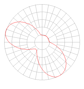 | |||||||||||||||||||
| Azimuth | Ratio | Azimuth | Ratio | Azimuth | Ratio | Azimuth | Ratio | |||||||||||||
| 0 | 0.184 | 10 | 0.181 | 20 | 0.185 | 30 | 0.190 | |||||||||||||
| 40 | 0.193 | 50 | 0.190 | 60 | 0.185 | 70 | 0.181 | |||||||||||||
| 80 | 0.184 | 90 | 0.202 | 100 | 0.312 | 110 | 0.479 | |||||||||||||
| 120 | 0.663 | 130 | 0.828 | 140 | 0.945 | 150 | 0.997 | |||||||||||||
| 155 | 1.000 | 160 | 0.977 | 170 | 0.872 | 180 | 0.710 | |||||||||||||
| 190 | 0.536 | 200 | 0.382 | 210 | 0.282 | 220 | 0.247 | |||||||||||||
| 230 | 0.282 | 240 | 0.382 | 250 | 0.536 | 260 | 0.710 | |||||||||||||
| 270 | 0.872 | 280 | 0.977 | 285 | 1.000 | 290 | 0.997 | |||||||||||||
| 300 | 0.946 | 310 | 0.828 | 320 | 0.663 | 330 | 0.479 | |||||||||||||
| 340 | 0.312 | 350 | 0.202 | |||||||||||||||||
Structure Registration Number 1030089 Structure Type: TOWER Registered To: WSMH, Inc. Structure Address: 4 Mi S .375 Mi E Halstead, KS County Name: Harvey County ASR Issued: 08/20/2021 Date Built: 09/21/2000 Site Elevation: 424 m (1391 ft.) Structure Height: 336.5 m (1104 ft.) Height Overall: 338 m (1109 ft.) Overall Height AMSL: 762 m (2500 ft.) FAA Determination: 07/08/1996 FAA Study #: 96-ACE-0159-OE FAA Circular #: 70/7460-1J Paint & Light FAA Chapters: 4, 7, 13 37-56-23.0 N 97-30-43.0 W (NAD 83) 37-56-23.0 N 97-30-41.8 W (Converted to NAD 27) |
4040 Broadway Suite 518 San Antonio, TX 78209 Phone: 210-222-0973 Corporation | Title: President Date: 10/03/2022 Application Certifier Mercury Broadcasting Company, Inc. 4040 Broadway Suite 308 San Antonio, TX 78209 Applicant Daniel A Kirkpatrick Baker & Hostetler, Llp 1050 Connecticut Ave Nw Suite 1100 Washington, DC 20036 | ||||||||||||||||||
