
FCCInfo.com
A Service of Cavell, Mertz & Associates, Inc.
(855) FCC-INFO
|
|
|
|
|
||||||||||||||||
|
|
Status: License Application Accepted: 08/15/2022 License Expires: 02/01/2022 File Number: -0000197531 FCC Website Links: LMS Facility Details This Application Other K33MN-D Applications Including Superseded Applications Mailing Address Correspondence for K33MN-D Correspondence related to application -0000197531 Service Contour - Open Street Map or USGS Map (51 dBu) Service Contour - KML / Google Earth (51 dBu) Rabbit Ears Info Search for K33MN-D Site Location: 38-39-37.7 N 92-07-22.0 W (NAD 83) Site Location: 38-39-37.6 N 92-07-21.3 W (Converted to NAD 27) ERP: 7 kW Polarization: Horizontally polarized R/C AGL: 30 m (98 ft.) R/C AMSL: 292.7 m (960 ft.) Emission Mask: Full Service Site Elevation: 262.7 m. (862 ft.) Height Overall*: 85.3 m (280 ft.) (* As Filed In This Application, may differ from ASR Data, Below.) Directional Antenna - Antenna Make/Model: ELTI ELTI UHF Panel Antenna ID: 1008435 Polarization: Horizontally polarized
| ||||||||||||||||||
| Antenna Data for Antenna Id: 1008435 K33MN-D LD File: -0000197531 ELTI - ELTI UHF Panel Service: LD Standard Pattern: Y | 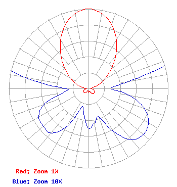 | ||||||||||||||||||
| Azimuth | Ratio | Azimuth | Ratio | Azimuth | Ratio | Azimuth | Ratio | ||||||||||||
| 0 | 1.000 | 10 | 0.955 | 20 | 0.851 | 30 | 0.700 | ||||||||||||
| 40 | 0.531 | 50 | 0.367 | 60 | 0.232 | 70 | 0.132 | ||||||||||||
| 80 | 0.052 | 90 | 0.028 | 100 | 0.053 | 110 | 0.075 | ||||||||||||
| 120 | 0.087 | 130 | 0.090 | 140 | 0.084 | 150 | 0.062 | ||||||||||||
| 160 | 0.038 | 170 | 0.044 | 180 | 0.050 | 190 | 0.033 | ||||||||||||
| 200 | 0.025 | 210 | 0.056 | 220 | 0.073 | 230 | 0.074 | ||||||||||||
| 240 | 0.072 | 250 | 0.060 | 260 | 0.033 | 270 | 0.029 | ||||||||||||
| 280 | 0.082 | 290 | 0.158 | 300 | 0.263 | 310 | 0.389 | ||||||||||||
| 320 | 0.537 | 330 | 0.700 | 340 | 0.851 | 350 | 0.955 | ||||||||||||
Structure Registration Number 1005497 Structure Type: TOWER Registered To: Subcarrier Communications Inc Structure Address: Greenway Drive Holts Summit, MO County Name: Callaway County ASR Issued: 02/08/2018 Date Built: 10/27/1998 Site Elevation: 262.7 m (862 ft.) Structure Height: 79.3 m (260 ft.) Height Overall: 85.3 m (280 ft.) Overall Height AMSL: 348 m (1142 ft.) FAA Determination: 01/12/2011 FAA Study #: 2010-ACE-3520-OE FAA Circular #: 70/7460-1H Paint & Light FAA Chapters: 4, 6, 13 PRIOR STUDY 1997-ACE-76-OE 38-39-37.7 N 92-07-22.0 W (NAD 83) 38-39-37.6 N 92-07-21.3 W (Converted to NAD 27) |
4370 Peachtree Road, Ne Atlanta, GA 30319 Phone: 202-750-1585 Limited Liability Company | Title: Manager Date: 08/15/2022 Application Certifier Lowcountry 34 Media, Llc 14 Tuxedo Drive Beaufort, SC 29907 Applicant Darryl K DeLawder Delawder Communications, Inc. P.o. Box 1095 Ashburn, VA 20146 President Davina Sashkin, Esq Baker & Hostetler Llp 1050 Connecticut Avenue, Nw Suite 1100 Washington, DC 20036 | |||||||||||||||||