
FCCInfo.com
A Service of Cavell, Mertz & Associates, Inc.
(855) FCC-INFO
|
|
WACN-LD from 02/19/1996 WACN-LD from 05/10/1990 |
|
|
||||||||||||||||
|
|
Status: License Application Accepted: 08/18/2022 License Expires: 12/01/2028 File Number: -0000197876 FCC Website Links: LMS Facility Details This Application Other WACN-LD Applications Including Superseded Applications Mailing Address Correspondence for WACN-LD Correspondence related to application -0000197876 Service Contour - Open Street Map or USGS Map (51 dBu) Service Contour - KML / Google Earth (51 dBu) Rabbit Ears Info Search for WACN-LD Site Location: 36-14-54.8 N 79-39-20.1 W (NAD 83) Site Location: 36-14-54.3 N 79-39-21.0 W (Converted to NAD 27) ERP: 15 kW Polarization: Horizontally polarized R/C AGL: 216 m (709 ft.) R/C AMSL: 441.6 m (1449 ft.) Emission Mask: Full Service Site Elevation: 225.6 m. (740 ft.) Height Overall*: 246.6 m (809 ft.) (* As Filed In This Application, may differ from ASR Data, Below.) Directional Antenna - Antenna Make/Model: Systems With Reliability Inc. SWLP16WC-RRR Antenna ID: 1009949 Polarization: Horizontally polarized | ||||||||||||||||||
| Antenna Data for Antenna Id: 1009949 WACN-LD LD File: -0000197876 Systems With Reliability Inc. - SWLP16WC-RRR Service: LD Standard Pattern: N Pattern and Field Values Include a 180° Clockwise Rotation | 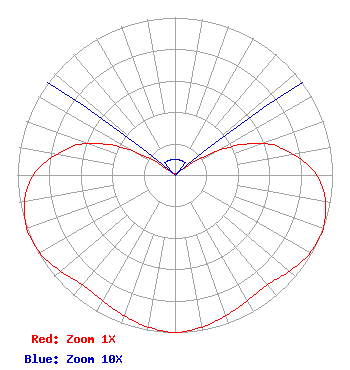 | ||||||||||||||||||
| Azimuth | Ratio | Azimuth | Ratio | Azimuth | Ratio | Azimuth | Ratio | ||||||||||||
| 0 | 0.010 | 10 | 0.010 | 20 | 0.010 | 30 | 0.010 | ||||||||||||
| 40 | 0.010 | 50 | 0.010 | 60 | 0.300 | 70 | 0.590 | ||||||||||||
| 80 | 0.760 | 90 | 0.900 | 100 | 0.970 | 110 | 1.000 | ||||||||||||
| 120 | 0.990 | 130 | 0.950 | 140 | 0.910 | 150 | 0.920 | ||||||||||||
| 160 | 0.950 | 170 | 0.980 | 180 | 1.000 | 190 | 0.980 | ||||||||||||
| 200 | 0.950 | 210 | 0.920 | 220 | 0.910 | 230 | 0.950 | ||||||||||||
| 240 | 0.990 | 250 | 1.000 | 260 | 0.970 | 270 | 0.900 | ||||||||||||
| 280 | 0.760 | 290 | 0.590 | 300 | 0.300 | 310 | 0.010 | ||||||||||||
| 320 | 0.010 | 330 | 0.010 | 340 | 0.010 | 350 | 0.010 | ||||||||||||
Structure Registration Number 1062557 Structure Type: GTOWER Registered To: American Towers, LLC Structure Address: 0.4 Miles East Of Us 29 & Sr 2665 (#306475) Reidsville, NC County Name: Rockingham County ASR Issued: 02/07/2020 Date Built: 08/11/2009 Site Elevation: 225.6 m (740 ft.) Structure Height: 224 m (735 ft.) Height Overall: 246.6 m (809 ft.) Overall Height AMSL: 472.2 m (1549 ft.) FAA Determination: 08/11/2009 FAA Study #: 2009-ASO-3920-OE Paint & Light FAA Chapters: B, D, H, 3, 6, 15, 21, 23 PRIOR STUDY 2009-ASO-1403-OE 36-14-54.8 N 79-39-20.1 W (NAD 83) 36-14-54.3 N 79-39-21.0 W (Converted to NAD 27) |
3901 Highway 121, South Bedford, TX 76021 Phone: 817-571-1229 Not-for-Profit | Title: Manager Date: 08/18/2022 Application Certifier WORD OF GOD FELLOWSHIP, INC. Word Of God Fellowship, Inc. 3901 Highway 121, South Bedford, TX 76021 Applicant RICHARD C GOETZ R & L Media Systems 135 N Country Club Dr Hendersonville, TN 37075 BROADCAST CONSULTANT ROBERT L OLENDER, Esq. Koerner & Olender, P.c. 7020 Richard Drive Bethesda, MD 20817 LEGAL REPRESENTATIVE | |||||||||||||||||