
FCCInfo.com
A Service of Cavell, Mertz & Associates, Inc.
(855) FCC-INFO
|
|
W28DQ-D from 11/17/2006 W28DQ-D from 10/02/2001 |
|
|
||||||||||||||||
|
|
Status: Construction Permit (Licensed And Silent) Application Accepted: 08/22/2022 W28DQ-D CP Expires: 08/01/2024 File Number: -0000197950 FCC Website Links: LMS Facility Details This Application Other W28DQ-D Applications Including Superseded Applications Mailing Address Correspondence for W28DQ-D Correspondence related to application -0000197950 Service Contour - Open Street Map or USGS Map (51 dBu) Service Contour - KML / Google Earth (51 dBu) Rabbit Ears Info Search for W28DQ-D Site Location: 43-26-37.4 N 72-27-16.3 W (NAD 83) Site Location: 43-26-37.1 N 72-27-18.0 W (Converted to NAD 27) ERP: 1 kW Polarization: Elliptically polarized R/C AGL: 26 m (85 ft.) R/C AMSL: 985.5 m (3233 ft.) Emission Mask: Full Service Site Elevation: 959.5 m. (3148 ft.) Height Overall*: 40.5 m (133 ft.) (* As Filed In This Application, may differ from ASR Data, Below.) Directional Antenna - Antenna Make/Model: Dielectric DLP-8M/VP Antenna ID: 1009344 Polarization: Elliptically polarized | ||||||||||||||||||
| Antenna Data for Antenna Id: 1009344 W28DQ-D LD File: -0000197950 Dielectric - DLP-8M/VP Service: LD Standard Pattern: Y Pattern and Field Values Include a 200° Clockwise Rotation | 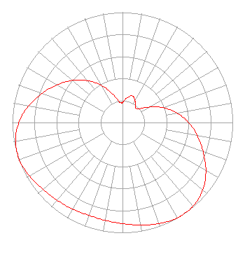 | ||||||||||||||||||
| Azimuth | Ratio | Azimuth | Ratio | Azimuth | Ratio | Azimuth | Ratio | ||||||||||||
| 0 | 0.184 | 10 | 0.226 | 20 | 0.257 | 30 | 0.227 | ||||||||||||
| 40 | 0.183 | 44 | 0.178 | 50 | 0.194 | 60 | 0.278 | ||||||||||||
| 70 | 0.393 | 80 | 0.502 | 90 | 0.599 | 100 | 0.688 | ||||||||||||
| 110 | 0.778 | 120 | 0.873 | 130 | 0.951 | 140 | 0.993 | ||||||||||||
| 147 | 1.000 | 150 | 0.998 | 160 | 0.976 | 170 | 0.944 | ||||||||||||
| 180 | 0.918 | 190 | 0.901 | 200 | 0.895 | 210 | 0.908 | ||||||||||||
| 220 | 0.921 | 230 | 0.942 | 240 | 0.974 | 250 | 0.995 | ||||||||||||
| 260 | 0.985 | 270 | 0.940 | 280 | 0.865 | 290 | 0.775 | ||||||||||||
| 300 | 0.684 | 310 | 0.593 | 320 | 0.497 | 330 | 0.392 | ||||||||||||
| 340 | 0.280 | 350 | 0.197 | 357 | 0.179 | ||||||||||||||
Structure Registration Number 1042342 Structure Type: LTOWER Registered To: Electronic Communications Association, Inc. Structure Address: N Peak Of Mount Ascutney Windsor, VT County Name: Windsor County ASR Issued: 02/28/2018 Date Built: 11/18/2017 Site Elevation: 959.5 m (3148 ft.) Structure Height: 30.4 m (100 ft.) Height Overall: 40.5 m (133 ft.) Overall Height AMSL: 1000 m (3281 ft.) FAA Determination: 02/26/2018 FAA Study #: 2018-ANE-960-OE Paint & Light FAA Chapters: NONE PRIOR STUDY 2017-ANE-4177-OE 43-26-37.4 N 72-27-16.3 W (NAD 83) 43-26-37.1 N 72-27-18.0 W (Converted to NAD 27) |
Hurst, TX 76054 Phone: 214-770-7770 Corporation | Title: Ceo Date: 08/22/2022 Application Certifier EDGE SPECTRUM, INC. Edge Spectrum, Inc. Hurst, TX 76054 Applicant Josh Weiss Ark Multicasting, Inc. Cedar Hill, TX 75106 CEO Susan Hansen B. W. St. Clair 2305 Vida Shaw Rd. New Iberia, LA 70563 Consultant Ari Meltzer Wiley Rein Llp 2050 M St Nw Washington, DC 20036 Caleb Weiss Ark Multicasting, Inc. Cedar Hill, TX 75106 President Randy Weiss Edge Spectrum, Inc. Hurst, TX 76054 CEO | |||||||||||||||||