
FCCInfo.com
A Service of Cavell, Mertz & Associates, Inc.
(855) FCC-INFO
|
|
W20EV-D from 02/22/2011 |
|
|
||||||||||||||||
|
|
Status: License Application Accepted: 08/22/2022 License Expires: 10/01/2029 File Number: -0000197960 FCC Website Links: LMS Facility Details This Application Other W20EV-D Applications Including Superseded Applications Mailing Address Correspondence for W20EV-D Correspondence related to application -0000197960 Service Contour - Open Street Map or USGS Map (51 dBu) Service Contour - KML / Google Earth (51 dBu) Rabbit Ears Info Search for W20EV-D Site Location: 44-15-42.2 N 85-17-37.1 W (NAD 83) Site Location: 44-15-42.2 N 85-17-36.9 W (Converted to NAD 27) ERP: 15 kW Polarization: Horizontally polarized R/C AGL: 12 m (39 ft.) R/C AMSL: 400 m (1312 ft.) Emission Mask: Full Service Site Elevation: 388 m. (1273 ft.) Height Overall*: 87 m (285 ft.) (* As Filed In This Application, may differ from ASR Data, Below.) Directional Antenna - Antenna Make/Model: DIELECTRIC TUA Antenna ID: 120649 Polarization: Horizontally polarized
| ||||||||||||||||||
| Antenna Data for Antenna Id: 120649 W20EV-D LD File: -0000197960 DIELECTRIC - TUA Service: LD Standard Pattern: Y Pattern and Field Values Include a 90° Clockwise Rotation | 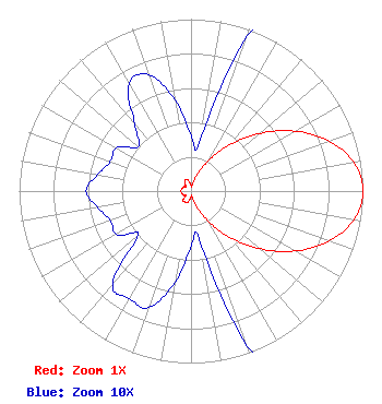 | ||||||||||||||||||
| Azimuth | Ratio | Azimuth | Ratio | Azimuth | Ratio | Azimuth | Ratio | ||||||||||||
| 0 | 0.032 | 10 | 0.029 | 20 | 0.096 | 30 | 0.202 | ||||||||||||
| 40 | 0.351 | 50 | 0.523 | 60 | 0.698 | 70 | 0.852 | ||||||||||||
| 80 | 0.962 | 90 | 1.000 | 100 | 0.962 | 110 | 0.852 | ||||||||||||
| 120 | 0.698 | 130 | 0.523 | 140 | 0.351 | 150 | 0.202 | ||||||||||||
| 160 | 0.096 | 170 | 0.029 | 180 | 0.032 | 190 | 0.054 | ||||||||||||
| 200 | 0.072 | 210 | 0.072 | 220 | 0.071 | 230 | 0.040 | ||||||||||||
| 240 | 0.050 | 250 | 0.050 | 260 | 0.055 | 270 | 0.061 | ||||||||||||
| 280 | 0.055 | 290 | 0.050 | 300 | 0.050 | 310 | 0.040 | ||||||||||||
| 320 | 0.051 | 330 | 0.072 | 340 | 0.072 | 350 | 0.054 | ||||||||||||
Structure Registration Number 1297679 Structure Type: GTOWER Registered To: K2 Towers II, LLC Structure Address: 340' Ne Of 5415 S. Lachance Rd. Lake City, MI County Name: Missaukee County ASR Issued: 12/24/2019 Date Built: 07/18/2016 Site Elevation: 388 m (1273 ft.) Structure Height: 84 m (276 ft.) Height Overall: 87 m (285 ft.) Overall Height AMSL: 475 m (1558 ft.) FAA Determination: 07/31/2015 FAA Study #: 2015-AGL-9989-OE FAA Circular #: 70/7460-1K Paint & Light FAA Chapters: 4, 8, 12 Removed expiration date from determination. Scenario 1./jjs/case#635066 44-15-42.2 N 85-17-37.1 W (NAD 83) 44-15-42.2 N 85-17-36.9 W (Converted to NAD 27) |
14 Tuxedo Drive Beaufort, SC 29907 Phone: 717-226-3535 Limited Liability Company | Title: Manager Date: 08/22/2022 Application Certifier Lowcountry 34 Media, Llc 14 Tuxedo Drive Beaufort, SC 29907 Applicant Darryl K DeLawder Delawder Communications Inc. P.o. Box 1095 Ashburn, VA 20146 President Davina Sashkin, Esq Baker & Hostetler Llp 1050 Connecticut Avenue, Nw Suite 1100 Washington, DC 20036 | |||||||||||||||||