
FCCInfo.com
A Service of Cavell, Mertz & Associates, Inc.
(855) FCC-INFO
|
|
W04DY-D from 08/21/2012 |
|
|
||||||||||||||||
|
|
Status: License Application Accepted: 08/23/2022 License Expires: 10/01/2029 File Number: -0000198193 FCC Website Links: LMS Facility Details This Application Other W04DY-D Applications Including Superseded Applications Mailing Address Correspondence for W04DY-D Correspondence related to application -0000198193 Service Contour - Open Street Map or USGS Map (43 dBu) Service Contour - KML / Google Earth (43 dBu) Rabbit Ears Info Search for W04DY-D Site Location: 44-06-01.0 N 84-35-55.0 W (NAD 83) Site Location: 44-06-00.9 N 84-35-54.9 W (Converted to NAD 27) ERP: 0.5 kW Polarization: Horizontally polarized R/C AGL: 13.5 m (44 ft.) R/C AMSL: 343.3 m (1126 ft.) Emission Mask: Full Service Site Elevation: 329.8 m. (1082 ft.) Height Overall*: 127 m (417 ft.) (* As Filed In This Application, may differ from ASR Data, Below.) Directional Antenna - Antenna Make/Model: SAMCO SAM-137 Antenna ID: 1009391 Polarization: Horizontally polarized | ||||||||||||||||||
| Antenna Data for Antenna Id: 1009391 W04DY-D LD File: -0000198193 SAMCO - SAM-137 Service: LD Standard Pattern: Y Pattern and Field Values Include a 180° Clockwise Rotation | 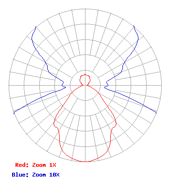 | ||||||||||||||||||
| Azimuth | Ratio | Azimuth | Ratio | Azimuth | Ratio | Azimuth | Ratio | ||||||||||||
| 0 | 0.140 | 10 | 0.130 | 20 | 0.130 | 30 | 0.120 | ||||||||||||
| 40 | 0.100 | 50 | 0.090 | 60 | 0.060 | 70 | 0.050 | ||||||||||||
| 80 | 0.030 | 90 | 0.030 | 100 | 0.030 | 110 | 0.090 | ||||||||||||
| 120 | 0.200 | 130 | 0.320 | 140 | 0.630 | 150 | 0.690 | ||||||||||||
| 160 | 0.890 | 170 | 0.970 | 180 | 1.000 | 190 | 0.970 | ||||||||||||
| 200 | 0.890 | 210 | 0.690 | 220 | 0.630 | 230 | 0.320 | ||||||||||||
| 240 | 0.200 | 250 | 0.090 | 260 | 0.030 | 270 | 0.030 | ||||||||||||
| 280 | 0.030 | 290 | 0.050 | 300 | 0.060 | 310 | 0.090 | ||||||||||||
| 320 | 0.100 | 330 | 0.120 | 340 | 0.130 | 350 | 0.130 | ||||||||||||
Structure Registration Number 1000591 Structure Type: TOWER Registered To: Vertical Bridge NTCF, LLC Structure Address: 4375 N Cassidy Rd Gladwin, MI County Name: Gladwin County ASR Issued: 06/03/2022 Date Built: 03/18/1994 Site Elevation: 329.8 m (1082 ft.) Structure Height: 122 m (400 ft.) Height Overall: 127 m (417 ft.) Overall Height AMSL: 456.8 m (1499 ft.) FAA Determination: 05/03/1993 FAA Study #: 93-AGL-1868-OE FAA Circular #: 70/7460-1H Paint & Light FAA Chapters: 4, 6, 13 44-06-01.0 N 84-35-55.0 W (NAD 83) 44-06-00.9 N 84-35-54.9 W (Converted to NAD 27) |
14 Tuxedo Drive Beaufort, SC 29907 Phone: 717-226-3535 Limited Liability Company | Title: Manager Date: 08/23/2022 Application Certifier Lowcountry 34 Media, Llc 14 Tuxedo Drive Beaufort, SC 29907 Applicant Darryl K DeLawder Delawder Communications Inc. P.o. Box 1095 Ashburn, VA 20146 President Davina Sashkin, Esq Baker & Hostetler Llp 1050 Connecticut Avenue, Nw Suite 1100 Washington, DC 20036 | |||||||||||||||||