
FCCInfo.com
A Service of Cavell, Mertz & Associates, Inc.
(855) FCC-INFO
|
|
K41KX-D from 08/05/2008 K41KX-D from 09/21/2005 |
|
|
||||||||||||||||
|
|
Status: Construction Permit (Licensed And Silent) Application Accepted: 08/29/2022 K41KX-D CP Expires: 08/01/2024 File Number: -0000197949 FCC Website Links: LMS Facility Details This Application Other K41KX-D Applications Including Superseded Applications Mailing Address Correspondence for K41KX-D Correspondence related to application -0000197949 Service Contour - Open Street Map or USGS Map (51 dBu) Service Contour - KML / Google Earth (51 dBu) Rabbit Ears Info Search for K41KX-D Site Location: 37-03-08.0 N 94-23-21.0 W (NAD 83) Site Location: 37-03-07.8 N 94-23-20.2 W (Converted to NAD 27) ERP: 10.75 kW Polarization: Horizontally polarized R/C AGL: 106 m (348 ft.) R/C AMSL: 437 m (1434 ft.) Emission Mask: Full Service Site Elevation: 331 m. (1086 ft.) Height Overall*: 152 m (499 ft.) (* As Filed In This Application, may differ from ASR Data, Below.) Directional Antenna - Antenna Make/Model: Dielectric DLP-8M/VP Antenna ID: 1009344 Polarization: Horizontally polarized | ||||||||||||||||||
| Antenna Data for Antenna Id: 1009344 K41KX-D LD File: -0000197949 Dielectric - DLP-8M/VP Service: LD Standard Pattern: Y | 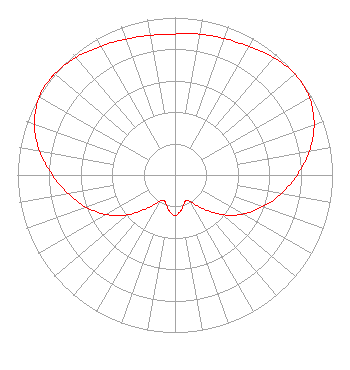 | ||||||||||||||||||
| Azimuth | Ratio | Azimuth | Ratio | Azimuth | Ratio | Azimuth | Ratio | ||||||||||||
| 0 | 0.895 | 10 | 0.908 | 20 | 0.921 | 30 | 0.942 | ||||||||||||
| 40 | 0.974 | 50 | 0.995 | 60 | 0.985 | 70 | 0.940 | ||||||||||||
| 80 | 0.865 | 90 | 0.775 | 100 | 0.684 | 110 | 0.593 | ||||||||||||
| 120 | 0.497 | 130 | 0.392 | 140 | 0.280 | 150 | 0.197 | ||||||||||||
| 157 | 0.179 | 160 | 0.184 | 170 | 0.226 | 180 | 0.257 | ||||||||||||
| 190 | 0.227 | 200 | 0.183 | 204 | 0.178 | 210 | 0.194 | ||||||||||||
| 220 | 0.278 | 230 | 0.393 | 240 | 0.502 | 250 | 0.599 | ||||||||||||
| 260 | 0.688 | 270 | 0.778 | 280 | 0.873 | 290 | 0.951 | ||||||||||||
| 300 | 0.993 | 307 | 1.000 | 310 | 0.998 | 320 | 0.976 | ||||||||||||
| 330 | 0.944 | 340 | 0.918 | 350 | 0.901 | ||||||||||||||
Structure Registration Number 1028313 Structure Type: TOWER Registered To: Educational Media Foundation Structure Address: 1132 Lark Road Joplin, MO County Name: Newton County ASR Issued: 10/13/2008 Date Built: 06/01/1998 Site Elevation: 331 m (1086 ft.) Structure Height: 152 m (499 ft.) Height Overall: 152 m (499 ft.) Overall Height AMSL: 483 m (1585 ft.) FAA Determination: 02/25/1997 FAA Study #: 97-ACE-0122-OE FAA Circular #: 70/7460-1J Paint & Light FAA Chapters: 3, 4, 5, 13 STRUCTURE REACHED GREATEST HEIGHT ON 10/10/98 SUPPLEMENTAL NOTICE STATES STRUCTURE REACHED GREATEST HEIGHT ON 10/31/1998 37-03-08.0 N 94-23-21.0 W (NAD 83) 37-03-07.8 N 94-23-20.2 W (Converted to NAD 27) |
Hurst, TX 76054 Phone: 214-770-7770 Corporation | Title: Ceo Date: 08/29/2022 Application Certifier EDGE SPECTRUM, INC. Edge Spectrum, Inc. Hurst, TX 76054 Applicant Randy Weiss Edge Spectrum, Inc. Hurst, TX 76054 CEO Caleb Weiss Ark Multicasting, Inc. Cedar Hill, TX 75106 President Josh Weiss Ark Multicasting, Inc. Cedar Hill, TX 75106 CEO Ari Meltzer Wiley Rein Llp 2050 M Street, Nw Washington, DC 20036 Susan Hansen B. W. St. Clair 2305 Vida Shaw Rd. New Iberia, LA 70563 Consultant | |||||||||||||||||