
FCCInfo.com
A Service of Cavell, Mertz & Associates, Inc.
(855) FCC-INFO
|
|
WODP-LD from 12/13/2010 |
|
|
||||||||||||||||
|
|
Status: License Application Accepted: 08/31/2022 License Expires: 08/01/2029 File Number: -0000198707 FCC Website Links: LMS Facility Details This Application Other WODP-LD Applications Including Superseded Applications Mailing Address Correspondence for WODP-LD Correspondence related to application -0000198707 Service Contour - Open Street Map or USGS Map (51 dBu) Service Contour - KML / Google Earth (51 dBu) Rabbit Ears Info Search for WODP-LD Site Location: 41-05-56.9 N 85-08-42.0 W (NAD 83) Site Location: 41-05-56.7 N 85-08-42.1 W (Converted to NAD 27) ERP: 15 kW Polarization: Circularly polarized Electrical Beam Tilt: .75 degrees R/C AGL: 110 m (361 ft.) R/C AMSL: 343.5 m (1127 ft.) Emission Mask: Full Service Site Elevation: 233.5 m. (766 ft.) Height Overall*: 128.3 m (421 ft.) (* As Filed In This Application, may differ from ASR Data, Below.) Directional Antenna - Antenna Make/Model: Kathrein 2x2 750 10210 Antenna ID: 1010003 Polarization: Circularly polarized | ||||||||||||||||||
| Antenna Data for Antenna Id: 1010003 WODP-LD LD File: -0000198707 Kathrein - 2x2 750 10210 Service: LD Standard Pattern: N Pattern and Field Values Include a 125.0° Clockwise Rotation | 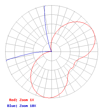 | ||||||||||||||||||
| Azimuth | Ratio | Azimuth | Ratio | Azimuth | Ratio | Azimuth | Ratio | ||||||||||||
| 5 | 0.287 | 15 | 0.451 | 25 | 0.619 | 35 | 0.772 | ||||||||||||
| 45 | 0.894 | 55 | 0.973 | 65 | 1.000 | 75 | 0.973 | ||||||||||||
| 85 | 0.894 | 95 | 0.772 | 105 | 0.617 | 115 | 0.559 | ||||||||||||
| 125 | 0.574 | 135 | 0.559 | 145 | 0.617 | 155 | 0.772 | ||||||||||||
| 165 | 0.894 | 175 | 0.973 | 185 | 1.000 | 195 | 0.973 | ||||||||||||
| 205 | 0.894 | 215 | 0.772 | 225 | 0.619 | 235 | 0.451 | ||||||||||||
| 245 | 0.287 | 255 | 0.145 | 265 | 0.043 | 275 | 0.001 | ||||||||||||
| 285 | 0.001 | 295 | 0.001 | 305 | 0.001 | 315 | 0.001 | ||||||||||||
| 325 | 0.001 | 335 | 0.001 | 345 | 0.043 | 355 | 0.145 | ||||||||||||
Structure Registration Number 1028214 Structure Type: GTOWER Registered To: American Towers LLC Structure Address: 2602 Cass Street (fort Wayne -cass St. #090136) Fort Wayne, IN County Name: Allen County ASR Issued: 01/11/2023 Date Built: 05/17/2005 Site Elevation: 233.5 m (766 ft.) Structure Height: 123.4 m (405 ft.) Height Overall: 128.3 m (421 ft.) Overall Height AMSL: 361.8 m (1187 ft.) FAA Determination: 01/03/2023 FAA Study #: 2022-AGL-4782-OE FAA Circular #: 70/7460-1K Paint & Light FAA Chapters: 4, 8, 12 PRIOR STUDY 2012-AGL-5804-OE 41-05-56.9 N 85-08-42.0 W (NAD 83) 41-05-56.7 N 85-08-42.1 W (Converted to NAD 27) |
295 Madison Avenue, 12th Floor New York, NY 10017 Phone: 954-606-5486 Corporation | Title: Vice President Of Regulatory Affairs Date: 08/31/2022 Application Certifier Dtv America Corporation 295 Madison Avenue, 12th Floor New York, NY 10017 Applicant MICHAEL VOGE Hc2 Broadcasting Holdings, Inc. 295 Madison Avenue, 12th Floor New York, NY 10017 DIRECTOR OF ENGINEERING OPERATIONS RENEE ILHARDT Hc2 Broadcasting Holdings, Inc. 295 Madison Avenue, 12th Floor New York, NY 10017 VP, REGULATORY AFFAIRS DAVID O'CONNOR Wilkinson, Barker, Knauer, Llp 1800 M Street Nw Suite 800n Washington, DC 20036 PARTNER | |||||||||||||||||
