
FCCInfo.com
A Service of Cavell, Mertz & Associates, Inc.
(855) FCC-INFO
|
|
from 09/24/2013 from 11/20/1995 from 08/04/1992 |
|
|
||||||||||||||||
|
|
Status: License Application Accepted: 09/01/2022 License Expires: 04/02/2029 File Number: -0000199083 FCC Website Links: LMS Facility Details This Application Other WTHV-LD Applications Including Superseded Applications Mailing Address Correspondence for WTHV-LD Correspondence related to application -0000199083 Service Contour - Open Street Map or USGS Map (51 dBu) Service Contour - KML / Google Earth (51 dBu) Rabbit Ears Info Search for WTHV-LD Site Location: 34-42-39.3 N 86-32-07.0 W (NAD 83) Site Location: 34-42-39.0 N 86-32-07.0 W (Converted to NAD 27) ERP: 15 kW Polarization: Horizontally polarized Electrical Beam Tilt: 1.05 degrees R/C AGL: 392.3 m (1287 ft.) R/C AMSL: 743.5 m (2439 ft.) Emission Mask: Full Service Site Elevation: 351.2 m. (1152 ft.) Height Overall*: 460.1 m (1510 ft.) (* As Filed In This Application, may differ from ASR Data, Below.) Directional Antenna - Antenna Make/Model: Dielectric TFU-8WB-R C160 Antenna ID: 1010014 Polarization: Horizontally polarized | ||||||||||||||||||
| Antenna Data for Antenna Id: 1010014 WTHV-LD LD File: -0000199083 Dielectric - TFU-8WB-R C160 Service: LD Standard Pattern: N Pattern and Field Values Include a 285° Clockwise Rotation | 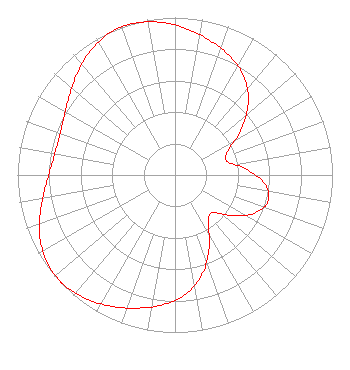 | ||||||||||||||||||
| Azimuth | Ratio | Azimuth | Ratio | Azimuth | Ratio | Azimuth | Ratio | ||||||||||||
| 5 | 0.929 | 15 | 0.880 | 25 | 0.830 | 35 | 0.763 | ||||||||||||
| 45 | 0.659 | 55 | 0.517 | 65 | 0.374 | 75 | 0.340 | ||||||||||||
| 85 | 0.448 | 95 | 0.567 | 105 | 0.614 | 115 | 0.567 | ||||||||||||
| 125 | 0.448 | 135 | 0.337 | 145 | 0.369 | 155 | 0.513 | ||||||||||||
| 165 | 0.657 | 175 | 0.760 | 185 | 0.826 | 195 | 0.875 | ||||||||||||
| 205 | 0.922 | 215 | 0.965 | 225 | 0.991 | 228 | 0.993 | ||||||||||||
| 235 | 0.985 | 245 | 0.946 | 255 | 0.885 | 265 | 0.825 | ||||||||||||
| 275 | 0.785 | 285 | 0.772 | 295 | 0.787 | 305 | 0.828 | ||||||||||||
| 315 | 0.889 | 325 | 0.951 | 335 | 0.992 | 342 | 1.000 | ||||||||||||
| 345 | 0.998 | 355 | 0.973 | ||||||||||||||||
Structure Registration Number 1204889 Structure Type: GTOWER Registered To: Gray Media Group, Inc. Structure Address: 5000 Governers Drive, 3 Miles Se Of Huntsville, AL County Name: Madison County ASR Issued: 01/16/2024 Date Built: 03/27/2020 Site Elevation: 351.2 m (1152 ft.) Structure Height: 447.1 m (1467 ft.) Height Overall: 460.1 m (1510 ft.) Overall Height AMSL: 811.3 m (2662 ft.) FAA Determination: 01/01/1979 FAA Study #: 79-ASO-2089-OE Paint & Light FAA Chapters: NONE 34-42-39.3 N 86-32-07.0 W (NAD 83) 34-42-39.0 N 86-32-07.0 W (Converted to NAD 27) |
4370 Peachtree Road, Ne Atlanta, GA 30319 Phone: 202-255-9298 Limited Liability Company | Title: Assistant Secretary Date: 09/01/2022 Application Certifier Gray Television Licensee, Llc 4370 Peachtree Road, Ne Atlanta, GA 30319 Applicant Joseph M. Davis, P.E. Chesapeake Rf Consultants, Llc 207 Old Dominion Road Yorktown, VA 23692 Consulting Engineer Joan Stewart Wiley Rein Llp 2050 M Street, Nw Washington, DC 20036 | |||||||||||||||||