
FCCInfo.com
A Service of Cavell, Mertz & Associates, Inc.
(855) FCC-INFO
|
|
|
|
|
||||||||||||||||
|
|
Status: Construction Permit (Licensed And Silent) Application Accepted: 09/02/2022 K42IM-D CP Expires: 08/01/2024 File Number: -0000199252 FCC Website Links: LMS Facility Details This Application Other K42IM-D Applications Including Superseded Applications Mailing Address Correspondence for K42IM-D Correspondence related to application -0000199252 Service Contour - Open Street Map or USGS Map (51 dBu) Service Contour - KML / Google Earth (51 dBu) Rabbit Ears Info Search for K42IM-D Site Location: 48-22-16.0 N 101-18-30.4 W (NAD 83) Site Location: 48-22-16.0 N 101-18-28.8 W (Converted to NAD 27) ERP: 0.9 kW Polarization: Horizontally polarized Electrical Beam Tilt: 0.75 degrees R/C AGL: 38.4 m (126 ft.) R/C AMSL: 534.5 m (1754 ft.) Emission Mask: Simple Site Elevation: 496.1 m. (1628 ft.) Height Overall*: 48.1 m (158 ft.) (* As Filed In This Application, may differ from ASR Data, Below.) Directional Antenna - Antenna Make/Model: DIELECTRIC DLP-8B/VP Antenna ID: 1004884 Polarization: Horizontally polarized | ||||||||||||||||||
| Antenna Data for Antenna Id: 1004884 K42IM-D LD File: -0000199252 DIELECTRIC - DLP-8B/VP Service: LD Standard Pattern: Y Pattern and Field Values Include a 120° Clockwise Rotation | 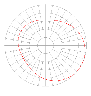 | ||||||||||||||||||
| Azimuth | Ratio | Azimuth | Ratio | Azimuth | Ratio | Azimuth | Ratio | ||||||||||||
| 0 | 0.627 | 10 | 0.633 | 20 | 0.653 | 30 | 0.686 | ||||||||||||
| 40 | 0.729 | 50 | 0.778 | 60 | 0.828 | 70 | 0.875 | ||||||||||||
| 80 | 0.918 | 90 | 0.953 | 100 | 0.979 | 110 | 0.995 | ||||||||||||
| 120 | 1.000 | 130 | 0.995 | 140 | 0.979 | 150 | 0.953 | ||||||||||||
| 160 | 0.918 | 170 | 0.875 | 180 | 0.828 | 190 | 0.778 | ||||||||||||
| 200 | 0.729 | 210 | 0.686 | 220 | 0.653 | 230 | 0.633 | ||||||||||||
| 240 | 0.627 | 250 | 0.632 | 260 | 0.646 | 270 | 0.662 | ||||||||||||
| 280 | 0.678 | 290 | 0.689 | 300 | 0.692 | 310 | 0.689 | ||||||||||||
| 320 | 0.678 | 330 | 0.662 | 340 | 0.646 | 350 | 0.632 | ||||||||||||
Structure Registration Number 1292869 Structure Type: MTOWER Registered To: Northwest Dakota Cellular of North Dakota Limited Partnership Structure Address: 128th Avenue Ne Minot, ND County Name: Ward County ASR Issued: 12/09/2016 Date Built: 02/05/2015 Site Elevation: 496.1 m (1628 ft.) Structure Height: 45.7 m (150 ft.) Height Overall: 48.1 m (158 ft.) Overall Height AMSL: 544.2 m (1785 ft.) FAA Determination: 03/12/2015 FAA Study #: 2015-AGL-2390-OE Paint & Light FAA Chapters: NONE PRIOR STUDY 2013-AGL-9722-OE 48-22-16.0 N 101-18-30.4 W (NAD 83) 48-22-16.0 N 101-18-28.8 W (Converted to NAD 27) |
Hurst, TX 76054 Phone: 214-770-7770 Corporation | Title: Ceo Date: 09/02/2022 Application Certifier EDGE SPECTRUM, INC. Edge Spectrum, Inc. Hurst, TX 76054 Applicant Susan Hansen B. W. St. Clair 2305 Vida Shaw Rd. New Iberia, LA 70563 Consultant Ari Meltzer Wiley Rein Llp 2050 M St Nw Washington, DC 20036 Josh Weiss Ark Multicasting, Inc. Cedar Hill, TX 75106 CEO Randy Weiss Edge Spectrum, Inc. Hurst, TX 76054 CEO Caleb Weiss Ark Multicasting, Inc. Cedar Hill, TX 75106 President | |||||||||||||||||