
FCCInfo.com
A Service of Cavell, Mertz & Associates, Inc.
(855) FCC-INFO
|
|
|
|
|
||||||||||||||||
|
|
Status: Application (Licensed And Silent) Application Accepted: 09/06/2022 License Expires: 09/06/2022 File Number: -0000199283 FCC Website Links: LMS Facility Details This Application Other K49LJ-D Applications Including Superseded Applications Mailing Address Correspondence for K49LJ-D Correspondence related to application -0000199283 Service Contour - Open Street Map or USGS Map (51 dBu) Service Contour - KML / Google Earth (51 dBu) Rabbit Ears Info Search for K49LJ-D Site Location: 42-44-37.0 N 106-18-33.0 W (NAD 83) Site Location: 42-44-37.1 N 106-18-30.9 W (Converted to NAD 27) ERP: 0.1 kW Polarization: Horizontally polarized R/C AGL: 6 m (20 ft.) R/C AMSL: 2446 m (8025 ft.) Emission Mask: Simple Site Elevation: 2440 m. (8005 ft.) Height Overall*: 103.6 m (340 ft.) (* As Filed In This Application, may differ from ASR Data, Below.) Directional Antenna - Antenna Make/Model: Sam SAMCO160 Antenna ID: 1009817 Polarization: Horizontally polarized | ||||||||||||||||||
| Antenna Data for Antenna Id: 1009817 K49LJ-D LD File: -0000199283 Sam - SAMCO160 Service: LD Standard Pattern: Y Pattern and Field Values Include a 345° Clockwise Rotation | 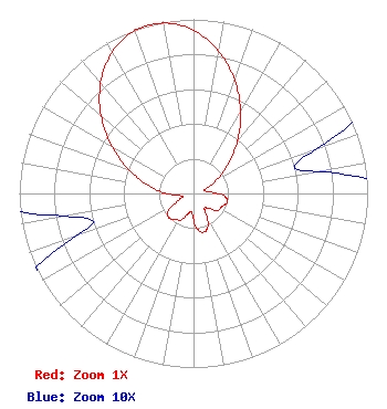 | ||||||||||||||||||
| Azimuth | Ratio | Azimuth | Ratio | Azimuth | Ratio | Azimuth | Ratio | ||||||||||||
| 5 | 0.888 | 15 | 0.764 | 25 | 0.617 | 35 | 0.465 | ||||||||||||
| 45 | 0.325 | 55 | 0.208 | 65 | 0.108 | 75 | 0.060 | ||||||||||||
| 85 | 0.100 | 95 | 0.180 | 105 | 0.200 | 115 | 0.180 | ||||||||||||
| 125 | 0.170 | 135 | 0.120 | 145 | 0.110 | 155 | 0.200 | ||||||||||||
| 165 | 0.230 | 175 | 0.200 | 185 | 0.110 | 195 | 0.120 | ||||||||||||
| 205 | 0.170 | 215 | 0.180 | 225 | 0.200 | 235 | 0.180 | ||||||||||||
| 245 | 0.100 | 255 | 0.060 | 265 | 0.108 | 275 | 0.208 | ||||||||||||
| 285 | 0.325 | 295 | 0.465 | 305 | 0.617 | 315 | 0.764 | ||||||||||||
| 325 | 0.888 | 335 | 0.973 | 345 | 1.000 | 355 | 0.973 | ||||||||||||
Structure Registration Number 1001086 Structure Type: TOWER Registered To: Mt. Rushmore Broadcasting, Inc. Structure Address: 8500 Casper Mountain Rd Casper, WY County Name: Natrona County ASR Issued: 11/01/2022 Date Built: 09/13/1995 Site Elevation: 2440 m (8005 ft.) Structure Height: 98 m (322 ft.) Height Overall: 103.6 m (340 ft.) Overall Height AMSL: 2543.6 m (8345 ft.) FAA Determination: 08/12/1994 FAA Study #: 94-ANM-0555-OE FAA Circular #: 70/7460-1H Paint & Light FAA Chapters: 3, 4, 5, 13 42-44-37.0 N 106-18-33.0 W (NAD 83) 42-44-37.1 N 106-18-30.9 W (Converted to NAD 27) |
Hurst, TX 76054 Phone: 214-770-7770 Corporation | Title: Ceo Date: 09/06/2022 Application Certifier EDGE SPECTRUM, INC. Edge Spectrum, Inc. Hurst, TX 76054 Applicant Josh Weiss Ark Multicasting, Inc. Cedar Hill, TX 75106 CEO Susan Hansen B. W. St. Clair 2305 Vida Shaw Rd. New Iberia, LA 70563 Consultant Ari Meltzer Wiley Rein Llp 2050 M St Nw Washington, DC 20036 Randy Weiss Edge Spectrum, Inc. Hurst, TX 76054 CEO Caleb Weiss Ark Multicasting, Inc. Cedar Hill, TX 75106 President | |||||||||||||||||