
FCCInfo.com
A Service of Cavell, Mertz & Associates, Inc.
(855) FCC-INFO
|
|
WUCW from 11/13/1998 WUCW from 04/20/1992 WUCW from 03/20/1992 |
Virtual Channel 23 |  |
|
||||||||||||||||||||||
|
|
Repacking Information: No changes Status: License Application Accepted: 09/20/2022 License Expires: 04/01/2022 File Number: -0000200294 FCC Website Links: LMS Facility Details This Application Other WUCW Applications Including Superseded Applications Mailing Address Correspondence for WUCW Correspondence related to application -0000200294 Service Contour - Open Street Map or USGS Map (41 dBu) Service Contour - KML / Google Earth (41 dBu) Public Inspection Files History Cards for WUCW Rabbit Ears Info Search for WUCW Site Location: 45-03-44.0 N 93-08-22.0 W (NAD 83) Site Location: 45-03-44.1 N 93-08-21.2 W (Converted to NAD 27) ERP: 65.78 kW Polarization: Horizontally polarized HAAT: 308.4 m (1012 ft.) Electrical Beam Tilt: 1.0 degree R/C AGL: 280.4 m (920 ft.) R/C AMSL: 584.3 m (1917 ft.) Site Elevation: 303.9 m. (997 ft.) Height Overall*: 437.7 m (1436 ft.) (* As Filed In This Application, may differ from ASR Data, Below.) Directional Antenna - Antenna Make/Model: Dielectric TLP-8B -R Antenna ID: 1010049 Polarization: Horizontally polarized
| |||||||||||||||||||||||||
| Antenna Data for Antenna Id: 1010049 WUCW DX File: -0000200294 Dielectric - TLP-8B -R Service: DX Standard Pattern: N Pattern and Field Values Include a 160° Clockwise Rotation | 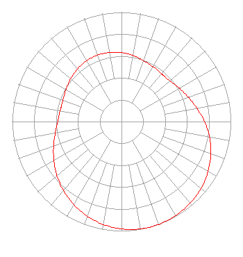 | |||||||||||||||||||||||||
| Azimuth | Ratio | Azimuth | Ratio | Azimuth | Ratio | Azimuth | Ratio | |||||||||||||||||||
| 0 | 0.631 | 10 | 0.613 | 20 | 0.592 | 30 | 0.579 | |||||||||||||||||||
| 40 | 0.570 | 42 | 0.570 | 50 | 0.579 | 60 | 0.610 | |||||||||||||||||||
| 70 | 0.650 | 80 | 0.699 | 90 | 0.759 | 100 | 0.817 | |||||||||||||||||||
| 110 | 0.869 | 120 | 0.914 | 130 | 0.951 | 140 | 0.975 | |||||||||||||||||||
| 150 | 0.993 | 160 | 1.000 | 170 | 0.996 | 180 | 0.981 | |||||||||||||||||||
| 190 | 0.955 | 200 | 0.920 | 210 | 0.876 | 220 | 0.826 | |||||||||||||||||||
| 230 | 0.771 | 240 | 0.714 | 250 | 0.661 | 260 | 0.615 | |||||||||||||||||||
| 270 | 0.583 | 280 | 0.569 | 285 | 0.568 | 290 | 0.571 | |||||||||||||||||||
| 300 | 0.586 | 310 | 0.607 | 320 | 0.627 | 330 | 0.640 | |||||||||||||||||||
| 340 | 0.645 | 350 | 0.641 | |||||||||||||||||||||||
Structure Registration Number 1023882 Structure Type: GTOWER Registered To: Telefarm Inc. Structure Address: 960 County Road F Shoreview, MN County Name: Ramsey County ASR Issued: 12/21/2022 Date Built: 01/10/2024 Site Elevation: 303.9 m (997 ft.) Structure Height: 397.5 m (1304 ft.) Height Overall: 437.7 m (1436 ft.) Overall Height AMSL: 741.6 m (2433 ft.) FAA Determination: 09/12/2022 FAA Study #: 2022-AGL-16608-OE FAA Circular #: 70/7460-1M Paint & Light FAA Chapters: 4, 9, 15 PRIOR STUDY 1998-AGL-4008-OE 45-03-44.0 N 93-08-22.0 W (NAD 83) 45-03-44.1 N 93-08-21.2 W (Converted to NAD 27) |
1200 Seventeenth Street, Nw Washington, DC 20036 Phone: 202-663-8195 Limited Liability Company | Title: Cfo Date: 09/20/2022 Application Certifier KLGT Licensee, LLC Klgt Licensee, Llc Pillsbury Winthrop Shaw Pittman Llp 1200 Seventeenth Street, Nw Washington, DC 20036 Applicant Paul A. Cicelski, Esq Lerman-senter Pllc 2001 L. Street Nw Suite 400 Washington, DC 20036 Legal Representative John E. Hidle, PE Carl T. Jones Corporation 7901 Yarnwood Court Springfield, VA 22153 Consulting Engineer | ||||||||||||||||||||||||
| ||||||||||||||||||||||||||
