
FCCInfo.com
A Service of Cavell, Mertz & Associates, Inc.
(855) FCC-INFO
|
|
KJDA-LD from 03/27/2012 |
|
|
||||||||||||||||
|
|
Status: STA – Special Temporary Authority (Licensed And Silent) Application Accepted: 09/20/2022 STA Expires: 06/14/2023 File Number: -0000200586 FCC Website Links: LMS Facility Details This Application Other KJDA-LD Applications Including Superseded Applications Mailing Address Correspondence for KJDA-LD Correspondence related to application -0000200586 Service Contour - Open Street Map or USGS Map (48 dBu) Service Contour - KML / Google Earth (48 dBu) Rabbit Ears Info Search for KJDA-LD Site Location: 34-01-58.0 N 96-48-01.0 W (NAD 83) Site Location: 34-01-57.6 N 96-47-60.0 W (Converted to NAD 27) ERP: 3 kW Polarization: Horizontally polarized R/C AGL: 400 m (1312 ft.) R/C AMSL: 671.2 m (2202 ft.) Emission Mask: Stringent Site Elevation: 271.2 m. (890 ft.) Height Overall*: 516.3 m (1694 ft.) (* As Filed In This Application, may differ from ASR Data, Below.) Directional Antenna - Antenna Make/Model: Scala CL-713 Antenna ID: 107781 Polarization: Horizontally polarized | ||||||||||||||||||
| Antenna Data for Antenna Id: 107781 KJDA-LD LD File: -0000200586 Scala - CL-713 Service: LD Standard Pattern: Y Pattern and Field Values Include a 180° Clockwise Rotation | 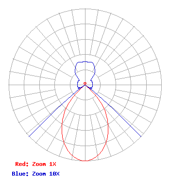 | ||||||||||||||||||
| Azimuth | Ratio | Azimuth | Ratio | Azimuth | Ratio | Azimuth | Ratio | ||||||||||||
| 0 | 0.030 | 10 | 0.030 | 20 | 0.030 | 30 | 0.025 | ||||||||||||
| 40 | 0.020 | 50 | 0.010 | 60 | 0.010 | 70 | 0.010 | ||||||||||||
| 80 | 0.010 | 90 | 0.010 | 100 | 0.010 | 110 | 0.010 | ||||||||||||
| 120 | 0.010 | 130 | 0.030 | 140 | 0.352 | 150 | 0.598 | ||||||||||||
| 160 | 0.805 | 170 | 0.945 | 180 | 1.000 | 190 | 0.945 | ||||||||||||
| 200 | 0.805 | 210 | 0.598 | 220 | 0.352 | 230 | 0.030 | ||||||||||||
| 240 | 0.010 | 250 | 0.010 | 260 | 0.010 | 270 | 0.010 | ||||||||||||
| 280 | 0.010 | 290 | 0.010 | 300 | 0.010 | 310 | 0.010 | ||||||||||||
| 320 | 0.020 | 330 | 0.025 | 340 | 0.030 | 350 | 0.030 | ||||||||||||
Structure Registration Number 1011273 Structure Type: TOWER Registered To: Gray Media Group, Inc. Structure Address: Hwy 99 8.05 Km Ssw Madill, OK County Name: Marshall County ASR Issued: 09/09/2020 Date Built: 02/01/1984 Site Elevation: 271.2 m (890 ft.) Structure Height: 487.6 m (1600 ft.) Height Overall: 516.3 m (1694 ft.) Overall Height AMSL: 787.5 m (2584 ft.) Paint & Light FAA Chapters: A1, B, F, H 34-01-58.0 N 96-48-01.0 W (NAD 83) 34-01-57.6 N 96-47-60.0 W (Converted to NAD 27) |
8330 Lyndon B Johnson Fwy Suite B400 Dallas, TX 75243 Phone: 214-434-5600 Corporation | Title: President Date: 09/20/2022 Application Certifier HISPANIC FAMILY CHRISTIAN NETWORK, INC. Hispanic Family Christian Network, Inc. 8330 Lyndon B Johnson Fwy Suite B400 Dallas, TX 75243 Applicant Dan J Alpert The Law Office Of Dan J. Alpert 2120 21st Rd. N Arlington, VA 22201 Legal Counsel | |||||||||||||||||