
FCCInfo.com
A Service of Cavell, Mertz & Associates, Inc.
(855) FCC-INFO
|
|
KHNL from 05/24/1984 KHNL from 11/28/1979 |
Virtual Channel 13 |  |
|
||||||||||||||||||||||||||||||
|
|
Repacking Information: No changes Status: License Application Accepted: 10/12/2022 License Expires: 02/01/2023 File Number: -0000202276 FCC Website Links: LMS Facility Details This Application Other KHNL Applications Including Superseded Applications Mailing Address Correspondence for KHNL Correspondence related to application -0000202276 Service Contour - Open Street Map or USGS Map (41 dBu) Service Contour - KML / Google Earth (41 dBu) Public Inspection Files History Cards for KHNL Rabbit Ears Info Search for KHNL Site Location: 21-23-52.0 N 158-06-00.0 W (NAD 83) Site Location: 21-24-03.4 N 158-06-09.9 W (Converted to NAD 27) ERP: 25 kW Polarization: Horizontally polarized HAAT: 629 m (2064 ft.) Electrical Beam Tilt: 0.75 degrees R/C AGL: 49.1 m (161 ft.) R/C AMSL: 805 m (2641 ft.) Site Elevation: 755.9 m. (2480 ft.) Height Overall*: 60.9 m (200 ft.) (* As Filed In This Application, may differ from ASR Data, Below.) Directional Antenna - Antenna Make/Model: DIELECTRIC TUA-BP3SP-6/18M-1-S Antenna ID: 90560 Polarization: Horizontally polarized
| |||||||||||||||||||||||||||||||||
| Antenna Data for Antenna Id: 90560 KHNL DT File: -0000202276 DIELECTRIC - TUA-BP3SP-6/18M-1-S Service: DT Standard Pattern: Y | 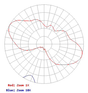 | |||||||||||||||||||||||||||||||||
| Azimuth | Ratio | Azimuth | Ratio | Azimuth | Ratio | Azimuth | Ratio | |||||||||||||||||||||||||||
| 0 | 0.482 | 10 | 0.436 | 20 | 0.503 | 30 | 0.468 | |||||||||||||||||||||||||||
| 40 | 0.428 | 50 | 0.529 | 60 | 0.625 | 70 | 0.639 | |||||||||||||||||||||||||||
| 80 | 0.684 | 90 | 0.841 | 100 | 0.969 | 108 | 1.000 | |||||||||||||||||||||||||||
| 110 | 0.995 | 120 | 0.920 | 130 | 0.802 | 140 | 0.684 | |||||||||||||||||||||||||||
| 150 | 0.573 | 160 | 0.367 | 170 | 0.131 | 180 | 0.158 | |||||||||||||||||||||||||||
| 190 | 0.110 | 200 | 0.087 | 210 | 0.095 | 220 | 0.132 | |||||||||||||||||||||||||||
| 230 | 0.114 | 240 | 0.214 | 250 | 0.465 | 260 | 0.622 | |||||||||||||||||||||||||||
| 270 | 0.718 | 280 | 0.835 | 290 | 0.946 | 300 | 0.987 | |||||||||||||||||||||||||||
| 310 | 0.918 | 320 | 0.769 | 330 | 0.676 | 340 | 0.658 | |||||||||||||||||||||||||||
| 350 | 0.598 | |||||||||||||||||||||||||||||||||
Structure Registration Number 1007114 Structure Type: Registered To: Gray Media Group, Inc. Structure Address: 4.8 Km Ne Of Nanakuli Palehua, HI County Name: Honolulu County ASR Issued: 02/11/2019 Date Built: 01/01/1989 Site Elevation: 755.9 m (2480 ft.) Structure Height: 60.9 m (200 ft.) Height Overall: 60.9 m (200 ft.) Overall Height AMSL: 816.8 m (2680 ft.) FAA Determination: 05/23/1989 FAA Study #: 88-AWP-938-OE Paint & Light FAA Chapters: NONE 21-23-52.0 N 158-06-00.0 W (NAD 83) 21-24-03.4 N 158-06-09.9 W (Converted to NAD 27) |
4370 Peachtree Road, Ne Atlanta, GA 30319 Phone: 404-504-9828 Limited Liability Company | Title: Assistant Secretary Date: 10/12/2022 Application Certifier GRAY TELEVISION LICENSEE, LLC Gray Television Licensee, Llc 4370 Peachtree Road, Ne Atlanta, GA 30319 Applicant David Burke Gray Television Licensee, Llc Rsa Tower, 20th Floor 201 Monroe Street Montgomery, AL 36014 Senior Vice President and CTO Joan Stewart, Esq Wiley Rein Llp 1776 K Street Nw Washington, DC 20006 Legal Counsel | ||||||||||||||||||||||||||||||||
|
| |||||||||||||||||||||||||||||||||
