
FCCInfo.com
A Service of Cavell, Mertz & Associates, Inc.
(855) FCC-INFO
|
|
K30QP-D from 03/11/2020 |
|
|
||||||||||||||||
|
|
Status: Application Application Accepted: 10/13/2022 License Expires: 06/01/2029 File Number: -0000202365 FCC Website Links: LMS Facility Details This Application Other W30ES-D Applications Including Superseded Applications Mailing Address Correspondence for W30ES-D Correspondence related to application -0000202365 Service Contour - Open Street Map or USGS Map (51 dBu) Service Contour - KML / Google Earth (51 dBu) Rabbit Ears Info Search for W30ES-D Site Location: 33-31-16.0 N 88-23-53.0 W (NAD 83) Site Location: 33-31-15.6 N 88-23-52.9 W (Converted to NAD 27) ERP: 15 kW Polarization: Elliptically polarized R/C AGL: 105.1 m (345 ft.) R/C AMSL: 158.4 m (520 ft.) Emission Mask: Full Service Site Elevation: 53.3 m. (175 ft.) Height Overall*: 124.4 m (408 ft.) (* As Filed In This Application, may differ from ASR Data, Below.) Directional Antenna - Antenna Make/Model: Dielectric DLP-8M Antenna ID: 1007534 Polarization: Elliptically polarized | ||||||||||||||||||
| Antenna Data for Antenna Id: 1007534 W30ES-D LD File: -0000202365 Dielectric - DLP-8M Service: LD Standard Pattern: Y Pattern and Field Values Include a 270° Clockwise Rotation | 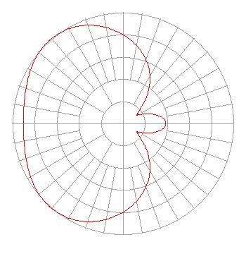 | ||||||||||||||||||
| Azimuth | Ratio | Azimuth | Ratio | Azimuth | Ratio | Azimuth | Ratio | ||||||||||||
| 0 | 0.800 | 10 | 0.711 | 20 | 0.609 | 30 | 0.488 | ||||||||||||
| 40 | 0.347 | 50 | 0.206 | 58 | 0.151 | 60 | 0.156 | ||||||||||||
| 70 | 0.252 | 80 | 0.349 | 90 | 0.387 | 100 | 0.349 | ||||||||||||
| 110 | 0.252 | 120 | 0.156 | 122 | 0.151 | 130 | 0.206 | ||||||||||||
| 140 | 0.347 | 150 | 0.488 | 160 | 0.609 | 170 | 0.711 | ||||||||||||
| 180 | 0.800 | 190 | 0.878 | 200 | 0.941 | 210 | 0.983 | ||||||||||||
| 220 | 1.000 | 222 | 1.000 | 230 | 0.991 | 240 | 0.963 | ||||||||||||
| 250 | 0.931 | 260 | 0.908 | 270 | 0.899 | 280 | 0.908 | ||||||||||||
| 290 | 0.931 | 300 | 0.963 | 310 | 0.991 | 318 | 1.000 | ||||||||||||
| 320 | 1.000 | 330 | 0.983 | 340 | 0.941 | 350 | 0.878 | ||||||||||||
Structure Registration Number 1039895 Structure Type: GTOWER Registered To: American Towers LLC Structure Address: 1.0 Km Northwest Of Intersection Of Sr-50-and Waterworks Road Columbus, MS County Name: Lowndes County ASR Issued: 12/28/2020 Date Built: 11/11/1992 Site Elevation: 53.3 m (175 ft.) Structure Height: 119.8 m (393 ft.) Height Overall: 124.4 m (408 ft.) Overall Height AMSL: 177.7 m (583 ft.) FAA Determination: 06/26/2018 FAA Study #: 2017-ASO-24534-OE FAA Circular #: 70/7460-1L Paint & Light FAA Chapters: 4, 8, 12 PRIOR STUDY 1992-ASO-1662-OE 33-31-16.0 N 88-23-53.0 W (NAD 83) 33-31-15.6 N 88-23-52.9 W (Converted to NAD 27) |
Hurst, TX 76054 Phone: 972-291-3750 Limited Liability Company | Title: Member/manager Date: 10/13/2022 Application Certifier EICB-TV EAST, LLC Eicb-tv East, Llc Hurst, TX 76054 Applicant Susan Hansen B. W. St. Clair 2305 Vida Shaw Rd New Iberia, LA 70563 CONSULTANT Ari Meltzer Wiley Rein Llp 2050 M St Nw Washington, DC 20036 Josh Weiss Ark Multicasting, Inc. Cedar Hill, TX 75106 CEO Caleb Weiss Ark Multicasting, Inc. Cedar Hill, TX 75106 Randy Weiss Eicb-tv East, Llc Hurst, TX 76054 Member/Manager | |||||||||||||||||