
FCCInfo.com
A Service of Cavell, Mertz & Associates, Inc.
(855) FCC-INFO
|
|
W18EW-D from 02/22/2011 |
|
|
||||||||||||||||
|
|
Status: License Application Accepted: 10/28/2022 License Expires: 08/01/2029 File Number: -0000203028 FCC Website Links: LMS Facility Details This Application Other W18EW-D Applications Including Superseded Applications Mailing Address Correspondence for W18EW-D Correspondence related to application -0000203028 Service Contour - Open Street Map or USGS Map (51 dBu) Service Contour - KML / Google Earth (51 dBu) Rabbit Ears Info Search for W18EW-D Site Location: 35-49-05.4 N 88-09-26.6 W (NAD 83) Site Location: 35-49-05.2 N 88-09-26.5 W (Converted to NAD 27) ERP: 1.56 kW Polarization: Horizontally polarized R/C AGL: 6.1 m (20 ft.) R/C AMSL: 195 m (640 ft.) Emission Mask: Full Service Site Elevation: 188.9 m. (620 ft.) Height Overall*: 79.2 m (260 ft.) (* As Filed In This Application, may differ from ASR Data, Below.) Directional Antenna - Antenna Make/Model: Scala SCA-1469B Antenna ID: 1010180 Polarization: Horizontally polarized | ||||||||||||||||||
| Antenna Data for Antenna Id: 1010180 W18EW-D LD File: -0000203028 Scala - SCA-1469B Service: LD Standard Pattern: N | 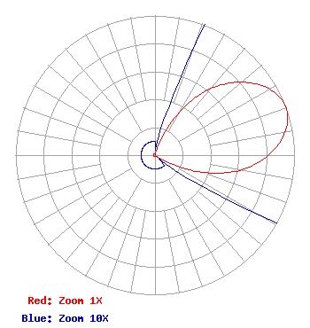 | ||||||||||||||||||
| Azimuth | Ratio | Azimuth | Ratio | Azimuth | Ratio | Azimuth | Ratio | ||||||||||||
| 0 | 0.010 | 10 | 0.010 | 20 | 0.086 | 30 | 0.361 | ||||||||||||
| 40 | 0.622 | 50 | 0.812 | 60 | 0.947 | 70 | 1.000 | ||||||||||||
| 80 | 0.947 | 90 | 0.812 | 100 | 0.622 | 110 | 0.361 | ||||||||||||
| 120 | 0.086 | 130 | 0.010 | 140 | 0.010 | 150 | 0.010 | ||||||||||||
| 160 | 0.010 | 170 | 0.010 | 180 | 0.010 | 190 | 0.010 | ||||||||||||
| 200 | 0.010 | 210 | 0.010 | 220 | 0.010 | 230 | 0.010 | ||||||||||||
| 240 | 0.010 | 250 | 0.010 | 260 | 0.010 | 270 | 0.010 | ||||||||||||
| 280 | 0.010 | 290 | 0.010 | 300 | 0.010 | 310 | 0.010 | ||||||||||||
| 320 | 0.010 | 330 | 0.010 | 340 | 0.010 | 350 | 0.010 | ||||||||||||
Structure Registration Number 1043104 Structure Type: LTOWER Registered To: American Towers, LLC Structure Address: 367 Peterson Loop (308884) Holladay, TN County Name: Decatur County ASR Issued: 02/07/2020 Date Built: 09/11/2008 Site Elevation: 188.9 m (620 ft.) Structure Height: 74.7 m (245 ft.) Height Overall: 79.2 m (260 ft.) Overall Height AMSL: 268.1 m (880 ft.) FAA Determination: 03/27/2013 FAA Study #: 2013-ASO-1641-OE FAA Circular #: 70/7460-1J Paint & Light FAA Chapters: 4, 8, 13 OM&L to remain the same as prior study = A MED-DUAL SYSTEM 35-49-05.4 N 88-09-26.6 W (NAD 83) 35-49-05.2 N 88-09-26.5 W (Converted to NAD 27) |
525 Blackburn Drive Augusta, GA 30907 Phone: 202-747-1694 Limited Liability Company | Title: Member Date: 10/28/2022 Application Certifier Sagamorehill Of Tennessee, Llc 525 Blackburn Drive Augusta, GA 30907 Applicant Aaron P Shainis Shainis & Peltzman, Chartered 1850 M St Nw Suite 240 Washington, DC 20006 Timothy Z Sawyer T Z Sawyer Technical Consultants 2130 Hutchison Grove Court Suite 100 Falls Church, VA 22043 Technical Consultant | |||||||||||||||||