
FCCInfo.com
A Service of Cavell, Mertz & Associates, Inc.
(855) FCC-INFO
|
|
W19FC-D from 02/22/2011 |
|
|
|||||||||||||||||
|
|
Status: Construction Permit Application Accepted: 10/24/2022 W19FC-D CP Expires: 12/28/2025 File Number: -0000202792 FCC Website Links: LMS Facility Details This Application Other W19FC-D Applications Including Superseded Applications Mailing Address Correspondence for W19FC-D Correspondence related to application -0000202792 Service Contour - Open Street Map or USGS Map (51 dBu) Service Contour - KML / Google Earth (51 dBu) Rabbit Ears Info Search for W19FC-D Site Location: 34-22-05.0 N 79-19-20.0 W (NAD 83) Site Location: 34-22-04.4 N 79-19-20.8 W (Converted to NAD 27) ERP: 15 kW Polarization: Horizontally polarized Electrical Beam Tilt: 1.0 degree R/C AGL: 85 m (279 ft.) R/C AMSL: 120.1 m (394 ft.) Emission Mask: Full Service Site Elevation: 35.1 m. (115 ft.) Height Overall*: 598 m (1962 ft.) (* As Filed In This Application, may differ from ASR Data, Below.) Directional Antenna - Antenna Make/Model: Dielectric DLP-12B Antenna ID: 1010165 Polarization: Horizontally polarized
| |||||||||||||||||||
| Antenna Data for Antenna Id: 1010165 W19FC-D LD File: -0000202792 Dielectric - DLP-12B Service: LD Standard Pattern: N Pattern and Field Values Include a 260° Clockwise Rotation | 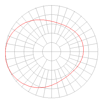 | |||||||||||||||||||
| Azimuth | Ratio | Azimuth | Ratio | Azimuth | Ratio | Azimuth | Ratio | |||||||||||||
| 0 | 0.653 | 10 | 0.633 | 20 | 0.627 | 30 | 0.632 | |||||||||||||
| 40 | 0.646 | 50 | 0.662 | 60 | 0.678 | 70 | 0.689 | |||||||||||||
| 80 | 0.692 | 90 | 0.689 | 100 | 0.678 | 110 | 0.662 | |||||||||||||
| 120 | 0.646 | 130 | 0.632 | 140 | 0.627 | 150 | 0.633 | |||||||||||||
| 160 | 0.653 | 170 | 0.686 | 180 | 0.729 | 190 | 0.778 | |||||||||||||
| 200 | 0.828 | 210 | 0.875 | 220 | 0.918 | 230 | 0.953 | |||||||||||||
| 240 | 0.979 | 250 | 0.995 | 260 | 1.000 | 270 | 0.995 | |||||||||||||
| 280 | 0.979 | 290 | 0.953 | 300 | 0.918 | 310 | 0.875 | |||||||||||||
| 320 | 0.828 | 330 | 0.778 | 340 | 0.729 | 350 | 0.686 | |||||||||||||
Structure Registration Number 1048801 Structure Type: TOWER Registered To: Nexstar Media Inc. Structure Address: 938 Pee Dee Church Road Dillon, SC County Name: Dillon County ASR Issued: 05/28/2021 Date Built: 05/31/2001 Site Elevation: 35.1 m (115 ft.) Structure Height: 576 m (1890 ft.) Height Overall: 598 m (1962 ft.) Overall Height AMSL: 633.1 m (2077 ft.) FAA Determination: 05/11/1998 FAA Study #: 98-ASO-2066-OE FAA Circular #: 70/7460-1J Paint & Light FAA Chapters: 4, 7, 13 34-22-05.0 N 79-19-20.0 W (NAD 83) 34-22-04.4 N 79-19-20.8 W (Converted to NAD 27) |
4370 Peachtree Road, Ne Atlanta, GA 30319 Phone: 202-750-1585 Limited Liability Company | Title: Assistant Secretary Date: 10/24/2022 Application Certifier Gray Television Licensee, Llc 4370 Peachtree Road, Ne Atlanta, GA 30319 Applicant Joseph M. Davis, P.E. Chesapeake Rf Consultants, Llc 207 Old Dominion Road Yorktown, VA 23692 Consulting Engineer Joan Stewart Wiley Rein Llp 2050 M Street Nw Washington, DC 20036 | ||||||||||||||||||