
FCCInfo.com
A Service of Cavell, Mertz & Associates, Inc.
(855) FCC-INFO
|
|
|
Virtual Channel 53 |  |
|
|||||||||||||||
|
|
Repacking Information: No changes Status: License Application Accepted: 11/01/2022 License Expires: 12/01/2022 File Number: -0000203129 FCC Website Links: LMS Facility Details This Application Other KAIL Applications Including Superseded Applications Mailing Address Correspondence for KAIL Correspondence related to application -0000203129 Service Contour - Open Street Map or USGS Map (36 dBu) Service Contour - KML / Google Earth (36 dBu) Public Inspection Files History Cards for KAIL Rabbit Ears Info Search for KAIL Site Location: 37-04-18.9 N 119-25-52.3 W (NAD 83) Site Location: 37-04-19.1 N 119-25-48.8 W (Converted to NAD 27) ERP: 48.8 kW Polarization: Elliptically polarized HAAT: 570.73 m (1872 ft.) Electrical Beam Tilt: 2 degrees R/C AGL: 38.5 m (126 ft.) R/C AMSL: 1393.6 m (4572 ft.) Site Elevation: 1355.1 m. (4446 ft.) Height Overall*: 97.9 m (321 ft.) (* As Filed In This Application, may differ from ASR Data, Below.) Directional Antenna - Antenna Make/Model: Kathrein 6X2 K52 34 517 Antenna ID: 29423 Polarization: Elliptically polarized | ||||||||||||||||||
| Antenna Data for Antenna Id: 29423 KAIL DT File: -0000203129 Kathrein - 6X2 K52 34 517 Service: DT Standard Pattern: Y | 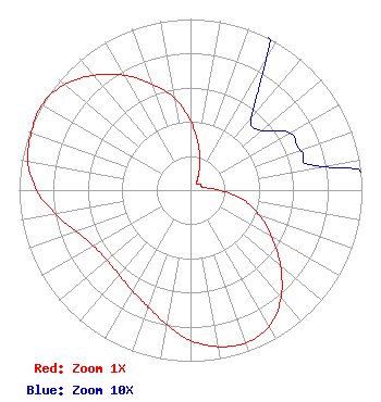 | ||||||||||||||||||
| Azimuth | Ratio | Azimuth | Ratio | Azimuth | Ratio | Azimuth | Ratio | ||||||||||||
| 0 | 0.405 | 10 | 0.265 | 20 | 0.160 | 30 | 0.088 | ||||||||||||
| 40 | 0.055 | 50 | 0.054 | 60 | 0.067 | 70 | 0.068 | ||||||||||||
| 80 | 0.079 | 90 | 0.172 | 100 | 0.311 | 110 | 0.428 | ||||||||||||
| 120 | 0.549 | 130 | 0.685 | 140 | 0.821 | 150 | 0.919 | ||||||||||||
| 160 | 0.949 | 170 | 0.929 | 180 | 0.878 | 190 | 0.799 | ||||||||||||
| 200 | 0.725 | 210 | 0.679 | 220 | 0.648 | 230 | 0.636 | ||||||||||||
| 240 | 0.654 | 250 | 0.707 | 260 | 0.801 | 270 | 0.898 | ||||||||||||
| 280 | 0.963 | 290 | 0.989 | 300 | 1.000 | 310 | 0.961 | ||||||||||||
| 320 | 0.876 | 330 | 0.775 | 340 | 0.660 | 350 | 0.548 | ||||||||||||
Structure Registration Number 1219741 Structure Type: TOWER Registered To: Beckman & Kinney Telecomm Structure Address: 42205 Radio Lane Auberry, CA County Name: Fresno County ASR Issued: 04/23/2009 Date Built: 01/17/2010 Site Elevation: 1355.1 m (4446 ft.) Structure Height: 97.9 m (321 ft.) Height Overall: 97.9 m (321 ft.) Overall Height AMSL: 1453 m (4767 ft.) FAA Determination: 10/28/2008 FAA Study #: 2008-AWP-6115-OE FAA Circular #: 70/7460-1K Paint & Light FAA Chapters: 4, 8, 12 PRIOR STUDY 2003-AWP-2067-OE 37-04-18.9 N 119-25-52.3 W (NAD 83) 37-04-19.1 N 119-25-48.8 W (Converted to NAD 27) |
Marion, IL 62959 Phone: 618-997-4700 Not-for-Profit | Title: President Date: 11/01/2022 Application Certifier Radiant Life Ministries, Inc. Marion, IL 62959 Applicant Joseph C Chautin, III Hardy, Carey, Chautin & Balkin, Llp 1080 W. Causeway Approach Mandeville, LA 70471 FCC Counsel Kyle THOMAS Fisher Smith And Fisher, Llc 4791 Wintergreen Court Woodbridge, VA 22192 | |||||||||||||||||