
FCCInfo.com
A Service of Cavell, Mertz & Associates, Inc.
(855) FCC-INFO
|
|
|
|
|
||||||||||||||||
|
|
Status: License Application Accepted: 12/22/2022 License Expires: 06/01/2023 File Number: -0000205864 FCC Website Links: LMS Facility Details This Application Other WNYJ-LD Applications Including Superseded Applications Mailing Address Correspondence for WNYJ-LD Correspondence related to application -0000205864 Service Contour - Open Street Map or USGS Map (51 dBu) Service Contour - KML / Google Earth (51 dBu) Rabbit Ears Info Search for WNYJ-LD Site Location: 41-43-07.5 N 73-59-45.4 W (NAD 83) Site Location: 41-43-07.2 N 73-59-46.9 W (Converted to NAD 27) ERP: 13.6 kW Polarization: Elliptically polarized Electrical Beam Tilt: 2 degrees R/C AGL: 231.7 m (760 ft.) R/C AMSL: 567.6 m (1862 ft.) Emission Mask: Full Service Site Elevation: 335.9 m. (1102 ft.) Height Overall*: 273.7 m (898 ft.) (* As Filed In This Application, may differ from ASR Data, Below.) Directional Antenna - Antenna Make/Model: DIELECTRIC TFU-16DSB-DSB Antenna ID: 1002675 Polarization: Elliptically polarized | ||||||||||||||||||
| Antenna Data for Antenna Id: 1002675 WNYJ-LD LD File: -0000205864 DIELECTRIC - TFU-16DSB-DSB Service: LD Standard Pattern: Y Pattern and Field Values Include a 145° Clockwise Rotation | 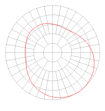 | ||||||||||||||||||
| Azimuth | Ratio | Azimuth | Ratio | Azimuth | Ratio | Azimuth | Ratio | ||||||||||||
| 5 | 0.592 | 15 | 0.579 | 25 | 0.570 | 35 | 0.579 | ||||||||||||
| 45 | 0.610 | 55 | 0.650 | 65 | 0.699 | 75 | 0.759 | ||||||||||||
| 85 | 0.817 | 95 | 0.869 | 105 | 0.914 | 115 | 0.951 | ||||||||||||
| 125 | 0.975 | 135 | 0.993 | 145 | 1.000 | 155 | 0.996 | ||||||||||||
| 165 | 0.981 | 175 | 0.955 | 185 | 0.920 | 195 | 0.876 | ||||||||||||
| 205 | 0.826 | 215 | 0.771 | 225 | 0.714 | 235 | 0.661 | ||||||||||||
| 245 | 0.615 | 255 | 0.583 | 265 | 0.569 | 275 | 0.571 | ||||||||||||
| 285 | 0.586 | 295 | 0.607 | 305 | 0.627 | 315 | 0.640 | ||||||||||||
| 325 | 0.643 | 335 | 0.641 | 345 | 0.631 | 355 | 0.613 | ||||||||||||
Structure Registration Number 1061739 Structure Type: GTOWER Registered To: American Towers LLC Structure Address: 1040 Reservoir Road (010328) Highland, NY County Name: Ulster County ASR Issued: 05/19/2015 Date Built: 01/19/2005 Site Elevation: 335.9 m (1102 ft.) Structure Height: 258.8 m (849 ft.) Height Overall: 273.7 m (898 ft.) Overall Height AMSL: 609.6 m (2000 ft.) FAA Determination: 05/08/2015 FAA Study #: 2015-AEA-2119-OE FAA Circular #: 70/7460-1K Paint & Light FAA Chapters: 4, 7, 12 PRIOR STUDY 2011-AEA-1889-OE 41-43-07.5 N 73-59-45.4 W (NAD 83) 41-43-07.2 N 73-59-46.9 W (Converted to NAD 27) |
150 S Arroyo Pkwy #103 Pasadena, CA 91105 Phone: 323-965-5400 Limited Liability Company | Title: Manager Date: 12/22/2022 Application Certifier Venture Technologies Group, Llc 5670 Wilshire Blvd., Suite 1620 Los Angeles, CA 90036 Applicant Lawrence Rogow Venture Technologies Group, Llc 5670 Wilshire Blvd., Suite 1620 Los Angeles, CA 90036 Joan Stewart Wiley Rein Llp 1776 K Street Nw Washington, DC 20006 | |||||||||||||||||