
FCCInfo.com
A Service of Cavell, Mertz & Associates, Inc.
(855) FCC-INFO
|
|
WDHC-LD from 03/31/1987 |
Virtual Channel 11 |
|
||||||||||||||||
|
|
Status: License Application Accepted: 12/22/2022 License Expires: 08/01/2021 File Number: -0000205847 FCC Website Links: LMS Facility Details This Application Other WDHC-LD Applications Including Superseded Applications Mailing Address Correspondence for WDHC-LD Correspondence related to application -0000205847 Service Contour - Open Street Map or USGS Map (43 dBu) Service Contour - KML / Google Earth (43 dBu) Rabbit Ears Info Search for WDHC-LD Site Location: 36-17-36.0 N 87-18-20.4 W (NAD 83) Site Location: 36-17-35.8 N 87-18-20.4 W (Converted to NAD 27) ERP: 3 kW Polarization: Circularly polarized R/C AGL: 168 m (551 ft.) R/C AMSL: 385.9 m (1266 ft.) Emission Mask: Stringent Site Elevation: 217.9 m. (715 ft.) Height Overall*: 281 m (922 ft.) (* As Filed In This Application, may differ from ASR Data, Below.) Directional Antenna - Antenna Make/Model: Propagation System Inc PSIFMLB-4C-90WS Antenna ID: 1008333 Polarization: Circularly polarized | ||||||||||||||||||
| Antenna Data for Antenna Id: 1008333 WDHC-LD LD File: -0000205847 Propagation System Inc - PSIFMLB-4C-90WS Service: LD Standard Pattern: Y | 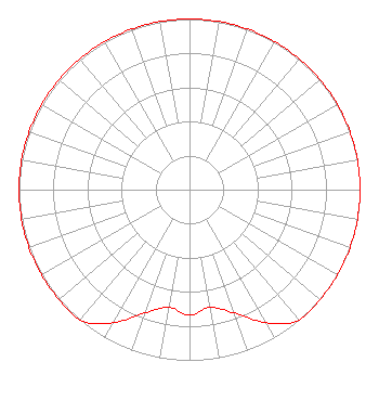 | ||||||||||||||||||
| Azimuth | Ratio | Azimuth | Ratio | Azimuth | Ratio | Azimuth | Ratio | ||||||||||||
| 0 | 1.000 | 10 | 1.000 | 20 | 1.000 | 30 | 1.000 | ||||||||||||
| 40 | 1.000 | 50 | 1.000 | 60 | 1.000 | 70 | 1.000 | ||||||||||||
| 80 | 1.000 | 90 | 1.000 | 100 | 1.000 | 110 | 1.000 | ||||||||||||
| 120 | 1.000 | 130 | 1.000 | 140 | 1.000 | 150 | 0.900 | ||||||||||||
| 160 | 0.770 | 170 | 0.700 | 180 | 0.735 | 190 | 0.700 | ||||||||||||
| 200 | 0.770 | 210 | 0.900 | 220 | 1.000 | 230 | 1.000 | ||||||||||||
| 240 | 1.000 | 250 | 1.000 | 260 | 1.000 | 270 | 1.000 | ||||||||||||
| 280 | 1.000 | 290 | 1.000 | 300 | 1.000 | 310 | 1.000 | ||||||||||||
| 320 | 1.000 | 330 | 1.000 | 340 | 1.000 | 350 | 1.000 | ||||||||||||
Structure Registration Number 1051456 Structure Type: GTOWER Registered To: WYCQ, INC. Structure Address: Cunningham Road, Ne Of Slayton Cumberland Furnace, TN County Name: Dickson County ASR Issued: 03/15/2017 Date Built: 01/29/2015 Site Elevation: 217.9 m (715 ft.) Structure Height: 281 m (922 ft.) Height Overall: 281 m (922 ft.) Overall Height AMSL: 498.9 m (1637 ft.) FAA Determination: 11/04/2014 FAA Study #: 2014-ASO-9188-OE FAA Circular #: 70/7460-1K Paint & Light FAA Chapters: 3, 4, 5, 12 FAA CHAPTERS 3,4,5,12; 70/7460-1K WITH BIRD LIGHTING DEVIATION SPECIAL CONDITION. PRIOR STUDY 2014-ASO-7337-OE 36-17-36.0 N 87-18-20.4 W (NAD 83) 36-17-35.8 N 87-18-20.4 W (Converted to NAD 27) |
108 West College St. Dickson, TN 37055 Phone: 615-397-5871 Corporation | Title: President Date: 12/22/2022 Application Certifier R & F COMMUNICATIONS INC. R & F Communications Inc. 108 West College St. Dickson, TN 37055 Applicant Davina S. Sashkin Bakerhostetler Llp 1050 Connecticut Ave., Nw Suite 1100 Washington, DC 20036 Attorney | |||||||||||||||||