
FCCInfo.com
A Service of Cavell, Mertz & Associates, Inc.
(855) FCC-INFO
|
|
|
Post-repack Channel 29 Virtual Channel 50 |
|
||||||||||||||||
|
|
Repacking Information: Pre-Repack Channel: 50 Post-Repack Channel: 29 Post-Repack ERP: 7.34 kW Phase: 2 Completion Deadline: 4/12/2019 Find nearby TV Facilities Status: STA – Special Temporary Authority Application Accepted: 12/18/2023 STA Expires: 07/17/2023 File Number: -0000206881 FCC Website Links: LMS Facility Details This Application Other KKAI Applications Including Superseded Applications Mailing Address Correspondence for KKAI Correspondence related to application -0000206881 Service Contour - Open Street Map or USGS Map (41 dBu) Service Contour - KML / Google Earth (41 dBu) Public Inspection Files Rabbit Ears Info Search for KKAI DTS Site Number: 1 Site Location: 21-25-19.6 N 157-45-27.1 W (NAD 83) Site Location: 21-25-31.0 N 157-45-37.0 W (Converted to NAD 27) ERP: 40 kW Polarization: Horizontally polarized HAAT: 373 m (1224 ft.) R/C AGL: 25.9 m (85 ft.) R/C AMSL: 167.6 m (550 ft.) Site Elevation: 141.7 m. (465 ft.) Height Overall*: 35.4 m (116 ft.) (* As Filed In This Application, may differ from ASR Data, Below.) Directional Antenna - Antenna Make/Model: Aldena US-Peanut Antenna ID: 1007391 Polarization: Horizontally polarized | ||||||||||||||||||
| Antenna Data for Antenna Id: 1007391 KKAI DD File: -0000206881 Aldena - US-Peanut Service: DD Standard Pattern: Y | 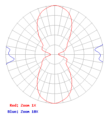 | ||||||||||||||||||
| Azimuth | Ratio | Azimuth | Ratio | Azimuth | Ratio | Azimuth | Ratio | ||||||||||||
| 0 | 1.000 | 10 | 0.966 | 20 | 0.881 | 30 | 0.708 | ||||||||||||
| 40 | 0.495 | 50 | 0.343 | 60 | 0.288 | 70 | 0.216 | ||||||||||||
| 80 | 0.093 | 90 | 0.093 | 100 | 0.108 | 110 | 0.257 | ||||||||||||
| 120 | 0.288 | 130 | 0.313 | 140 | 0.495 | 150 | 0.708 | ||||||||||||
| 160 | 0.871 | 170 | 0.955 | 180 | 1.000 | 190 | 0.966 | ||||||||||||
| 200 | 0.881 | 210 | 0.708 | 220 | 0.495 | 230 | 0.343 | ||||||||||||
| 240 | 0.288 | 250 | 0.216 | 260 | 0.093 | 270 | 0.093 | ||||||||||||
| 280 | 0.108 | 290 | 0.257 | 300 | 0.288 | 310 | 0.313 | ||||||||||||
| 320 | 0.495 | 330 | 0.708 | 340 | 0.871 | 350 | 0.955 | ||||||||||||
Structure Registration Number 1246610 Structure Type: LTOWER Registered To: HAWAII CATHOLIC TV, INC. Structure Address: 43-258 Kaneohe Bay Drive Kaneohe, HI County Name: Honolulu County ASR Issued: 06/02/2018 Date Built: 01/01/1990 Site Elevation: 141.7 m (465 ft.) Structure Height: 35.4 m (116 ft.) Height Overall: 35.4 m (116 ft.) Overall Height AMSL: 177.1 m (581 ft.) FAA Determination: 11/30/1987 FAA Study #: 87-AWP-697-OE Paint & Light FAA Chapters: NONE 21-25-19.6 N 157-45-27.1 W (NAD 83) 21-25-31.0 N 157-45-37.0 W (Converted to NAD 27) |
38955 Hills Tech Dr. Farmington, HI 48331 Phone: 248-536-0776 Limited Liability Company | Title: General Manager Date: 01/13/2023 Application Certifier Kailua Television, Llc P.o. Box 8969 Honolulu, HI 96810 Applicant Ari Meltzer, Esq Wiley Rein Llp 2050 M Street, N.w. Washington, DC 20036 | |||||||||||||||||