
FCCInfo.com
A Service of Cavell, Mertz & Associates, Inc.
(855) FCC-INFO
|
|
WWDP from 01/13/1998 WWDP from 02/04/1988 WWDP from 10/24/1986 |
Virtual Channel 46 |
|
||||||||||||||||
|
|
WWDP is a channel sharing host for WMFP, Foxborough, Massachusetts Repacking Information: No changes Status: Construction Permit Application Accepted: 02/01/2023 WWDP CP Expires: 02/07/2026 File Number: -0000210032 FCC Website Links: LMS Facility Details This Application Other WWDP Applications Including Superseded Applications Mailing Address Correspondence for WWDP Correspondence related to application -0000210032 Service Contour - Open Street Map or USGS Map (41 dBu) Service Contour - KML / Google Earth (41 dBu) Public Inspection Files Rabbit Ears Info Search for WWDP Site Location: 42-18-37.0 N 71-14-12.0 W (NAD 83) Site Location: 42-18-36.6 N 71-14-13.8 W (Converted to NAD 27) ERP: 1000 kW Polarization: Circularly polarized HAAT: 318.4 m (1045 ft.) Electrical Beam Tilt: 2.0 degrees R/C AGL: 315.4 m (1035 ft.) R/C AMSL: 362 m (1188 ft.) Site Elevation: 46.6 m. (153 ft.) Height Overall*: 395.1 m (1296 ft.) (* As Filed In This Application, may differ from ASR Data, Below.) Directional Antenna - Antenna Make/Model: Alive Telecom ATC-BCC830CF-V6-36 Antenna ID: 1009660 Polarization: Circularly polarized | ||||||||||||||||||
| Antenna Data for Antenna Id: 1009660 WWDP DT File: -0000210032 Alive Telecom - ATC-BCC830CF-V6-36 Service: DT Standard Pattern: Y Pattern and Field Values Include a 160.0° Clockwise Rotation | 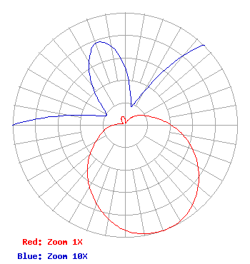 | ||||||||||||||||||
| Azimuth | Ratio | Azimuth | Ratio | Azimuth | Ratio | Azimuth | Ratio | ||||||||||||
| 0 | 0.051 | 10 | 0.028 | 20 | 0.017 | 30 | 0.035 | ||||||||||||
| 40 | 0.080 | 50 | 0.125 | 60 | 0.168 | 70 | 0.224 | ||||||||||||
| 80 | 0.304 | 90 | 0.409 | 100 | 0.525 | 110 | 0.640 | ||||||||||||
| 120 | 0.750 | 130 | 0.849 | 140 | 0.932 | 150 | 0.987 | ||||||||||||
| 160 | 1.000 | 170 | 0.983 | 180 | 0.939 | 190 | 0.850 | ||||||||||||
| 200 | 0.745 | 210 | 0.634 | 220 | 0.521 | 230 | 0.405 | ||||||||||||
| 240 | 0.296 | 250 | 0.223 | 260 | 0.165 | 270 | 0.101 | ||||||||||||
| 280 | 0.049 | 290 | 0.023 | 300 | 0.019 | 310 | 0.028 | ||||||||||||
| 320 | 0.045 | 330 | 0.064 | 340 | 0.077 | 350 | 0.071 | ||||||||||||
Structure Registration Number 1003433 Structure Type: GTOWER Registered To: American Towers LLC Structure Address: 350 Cedar Street (282685) Needham Heights, MA County Name: Norfolk County ASR Issued: 04/07/2023 Date Built: 01/01/1957 Site Elevation: 46.6 m (153 ft.) Structure Height: 363.4 m (1192 ft.) Height Overall: 395.1 m (1296 ft.) Overall Height AMSL: 441.7 m (1449 ft.) FAA Determination: 02/08/2023 FAA Study #: 2022-ANE-1323-OE FAA Circular #: 70/7460-1L Paint & Light FAA Chapters: 3, 4, 5, 12 OM&L to remain the same as prior study = PAINT/RED LIGHTS 42-18-37.2 N 71-14-11.7 W (NAD 83) 42-18-36.8 N 71-14-13.5 W (Converted to NAD 27) |
800 Westchester Avenue, S. 640 Rye Brook, NY 10573 Phone: 914-417-2700 Limited Liability Company | Title: Chief Operating Officer Date: 02/01/2023 Application Certifier RNN BOSTON LICENSE CO., LLC Rnn Boston License Co., Llc 800 Westchester Avenue, S. 640 Rye Brook, NY 10573 Applicant Christina Burrow Cooley Llp 1299 Pennsylvania Avenue Nw Suite 700 Washington, DC 20004 Legal Reprensetative | |||||||||||||||||