
FCCInfo.com
A Service of Cavell, Mertz & Associates, Inc.
(855) FCC-INFO
|
|
KNGF from 09/13/2022 |
|
|
||||||||||||||||
|
|
Status: License Application Accepted: 02/09/2023 License Expires: 04/01/2030 File Number: -0000210593 FCC Website Links: LMS Facility Details This Application Other KNGF Applications Including Superseded Applications Mailing Address Correspondence for KNGF Correspondence related to application -0000210593 Service Contour - Open Street Map or USGS Map (41 dBu) Service Contour - KML / Google Earth (41 dBu) Public Inspection Files Rabbit Ears Info Search for KNGF Site Location: 47-20-32.0 N 97-17-21.0 W (NAD 83) Site Location: 47-20-32.1 N 97-17-19.7 W (Converted to NAD 27) ERP: 720 kW Polarization: Elliptically polarized HAAT: 593.9 m (1948 ft.) Electrical Beam Tilt: 1.5 degrees R/C AGL: 599.5 m (1967 ft.) R/C AMSL: 896.7 m (2942 ft.) Site Elevation: 297.2 m. (975 ft.) Height Overall*: 605.6 m (1987 ft.) (* As Filed In This Application, may differ from ASR Data, Below.) Directional Antenna - Antenna Make/Model: DIELECTRIC TUM-4P190-10/30H-1-R Antenna ID: 1005249 Polarization: Elliptically polarized | ||||||||||||||||||
| Antenna Data for Antenna Id: 1005249 KNGF DT File: -0000210593 DIELECTRIC - TUM-4P190-10/30H-1-R Service: DT Standard Pattern: Y | 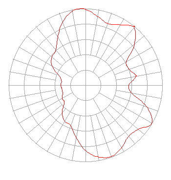 | ||||||||||||||||||
| Azimuth | Ratio | Azimuth | Ratio | Azimuth | Ratio | Azimuth | Ratio | ||||||||||||
| 0 | 0.989 | 10 | 0.910 | 20 | 0.856 | 30 | 0.907 | ||||||||||||
| 39 | 0.985 | 40 | 0.984 | 50 | 0.831 | 60 | 0.614 | ||||||||||||
| 70 | 0.602 | 79 | 0.666 | 80 | 0.665 | 90 | 0.564 | ||||||||||||
| 100 | 0.609 | 110 | 0.852 | 120 | 0.992 | 130 | 0.897 | ||||||||||||
| 140 | 0.873 | 150 | 0.940 | 160 | 0.992 | 170 | 0.952 | ||||||||||||
| 180 | 0.854 | 190 | 0.695 | 200 | 0.561 | 210 | 0.543 | ||||||||||||
| 220 | 0.474 | 230 | 0.358 | 240 | 0.348 | 250 | 0.316 | ||||||||||||
| 260 | 0.310 | 270 | 0.322 | 280 | 0.316 | 290 | 0.368 | ||||||||||||
| 300 | 0.504 | 310 | 0.570 | 320 | 0.598 | 330 | 0.722 | ||||||||||||
| 340 | 0.872 | 350 | 0.979 | 356 | 1.000 | ||||||||||||||
Structure Registration Number 1046244 Structure Type: GTOWER Registered To: Gray Media Group, Inc. Structure Address: 3 Miles West Blanchard, ND County Name: Traill County ASR Issued: 09/09/2020 Date Built: 08/13/1963 Site Elevation: 297.2 m (975 ft.) Structure Height: 605.6 m (1987 ft.) Height Overall: 605.6 m (1987 ft.) Overall Height AMSL: 902.8 m (2962 ft.) FAA Determination: 10/02/2019 FAA Study #: 2019-AGL-11540-OE FAA Circular #: 70/7460-1L Paint & Light FAA Chapters: 3, 4, 5, 12 PRIOR STUDY 2018-AGL-15816-OE 47-20-32.0 N 97-17-21.0 W (NAD 83) 47-20-32.1 N 97-17-19.7 W (Converted to NAD 27) |
200 East Broadway Steele, ND 58482 Phone: 701-475-1246 Corporation | Title: Cto/vice President Date: 02/09/2023 Application Certifier Bek Sports Network, Inc. 200 East Broadway Steele, ND 58482 Applicant Kevin T Fisher Smith And Fisher, Llc 4791 Wintergreen Court Woodbridge, VA 22192 Engineering Consultant Steven A Rowings Akin Gump Strauss Hauer & Feld Llp Robert S. Strauss Tower 2001 K Street, N.w. Washington D.c., DC 20006 | |||||||||||||||||