
FCCInfo.com
A Service of Cavell, Mertz & Associates, Inc.
(855) FCC-INFO
|
|
WAOE from 09/08/1995 |
Post-repack Channel 33 Virtual Channel 59 |  |
|
|||||||||||||||||||||
|
|
Repacking Information: Pre-Repack Channel: 39 Post-Repack Channel: 33 Post-Repack ERP: 23.1 kW Phase: 7 Completion Deadline: 1/17/2020 Find nearby TV Facilities Status: License Application Accepted: 02/14/2023 License Expires: 12/01/2021 File Number: -0000210797 FCC Website Links: LMS Facility Details This Application Other WTVK Applications Including Superseded Applications Mailing Address Correspondence for WTVK Correspondence related to application -0000210797 Service Contour - Open Street Map or USGS Map (36 dBu) Service Contour - KML / Google Earth (36 dBu) Public Inspection Files Rabbit Ears Info Search for WTVK Site Location: 41-16-54.6 N 88-56-11.1 W (NAD 83) Site Location: 41-16-54.5 N 88-56-10.8 W (Converted to NAD 27) ERP: 24 kW Polarization: Elliptically polarized HAAT: 212 m (696 ft.) Electrical Beam Tilt: 0.50 degrees R/C AGL: 404 m (1325 ft.) R/C AMSL: 596.6 m (1957 ft.) Site Elevation: 192.6 m. (632 ft.) Height Overall*: 418.6 m (1373 ft.) (* As Filed In This Application, may differ from ASR Data, Below.) Directional Antenna - Antenna Make/Model: ALIVE TELECOM ATC-BCE04H-VP1-10 Antenna ID: 1008363 Polarization: Elliptically polarized
| ||||||||||||||||||||||||
| Antenna Data for Antenna Id: 1008363 WTVK DT File: -0000210797 ALIVE TELECOM - ATC-BCE04H-VP1-10 Service: DT Standard Pattern: N Pattern and Field Values Include a 220° Clockwise Rotation | 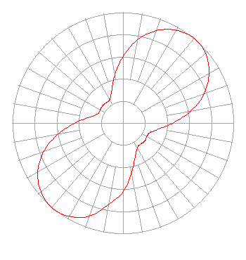 | ||||||||||||||||||||||||
| Azimuth | Ratio | Azimuth | Ratio | Azimuth | Ratio | Azimuth | Ratio | ||||||||||||||||||
| 0 | 0.600 | 10 | 0.764 | 20 | 0.889 | 30 | 0.967 | ||||||||||||||||||
| 40 | 1.000 | 50 | 0.974 | 60 | 0.897 | 70 | 0.781 | ||||||||||||||||||
| 80 | 0.622 | 90 | 0.451 | 100 | 0.324 | 110 | 0.258 | ||||||||||||||||||
| 120 | 0.248 | 130 | 0.256 | 140 | 0.248 | 150 | 0.258 | ||||||||||||||||||
| 160 | 0.324 | 170 | 0.451 | 180 | 0.622 | 190 | 0.748 | ||||||||||||||||||
| 200 | 0.897 | 210 | 0.974 | 220 | 1.000 | 230 | 0.968 | ||||||||||||||||||
| 240 | 0.889 | 250 | 0.764 | 260 | 0.600 | 270 | 0.432 | ||||||||||||||||||
| 280 | 0.302 | 290 | 0.242 | 300 | 0.237 | 310 | 0.242 | ||||||||||||||||||
| 320 | 0.237 | 330 | 0.242 | 340 | 0.302 | 350 | 0.432 | ||||||||||||||||||
Structure Registration Number 1028357 Structure Type: GTOWER Registered To: American Towers LLC Structure Address: 6.1 Km Sw Int Chicago Rd & Sr 71 Oglesby, IL County Name: LaSalle County ASR Issued: 01/05/2021 Date Built: 11/01/2014 Site Elevation: 192.6 m (632 ft.) Structure Height: 418.6 m (1373 ft.) Height Overall: 418.6 m (1373 ft.) Overall Height AMSL: 611.2 m (2005 ft.) FAA Determination: 06/11/2014 FAA Study #: 2014-AGL-3750-OE FAA Circular #: 70/7460-1F Paint & Light FAA Chapters: 4, 6, 9 PRIOR STUDY 1985-AGL-475-OE 41-16-54.6 N 88-56-11.1 W (NAD 83) 41-16-54.5 N 88-56-10.8 W (Converted to NAD 27) |
150 S Arroyo Pkwy #103 Pasadena, CA 91105 Phone: 323-965-5400 Limited Liability Company | Title: Manager Date: 02/14/2023 Application Certifier Four Seasons Peoria, Llc 5670 Wilshire Blvd., Suite 1620 Los Angeles, CA 90036 Applicant Ari Meltzer Wiley Rein Llp 2050 M Street Nw Washington, DC 20036 Lawrence rogow Four Seasons Peoria, Llc 5670 Wilshire Blvd., Suite 1620 Los Angeles, CA 90036 Manager Joan Stewart Wiley Rein Llp 2050 M Street Nw Washington, DC 20036 | |||||||||||||||||||||||
| |||||||||||||||||||||||||