
FCCInfo.com
A Service of Cavell, Mertz & Associates, Inc.
(855) FCC-INFO
|
|
WYIN from 02/04/1987 WYIN from 01/18/1987 |
Virtual Channel 56 |  |
|
|||||||||||||||||||||
|
|
Repacking Information: No changes Status: Construction Permit Application Accepted: 02/17/2023 WYIN CP Expires: 02/24/2026 File Number: -0000210997 FCC Website Links: LMS Facility Details This Application Other WYIN Applications Including Superseded Applications Mailing Address Correspondence for WYIN Correspondence related to application -0000210997 Service Contour - Open Street Map or USGS Map (41 dBu) Service Contour - KML / Google Earth (41 dBu) Public Inspection Files History Cards for WYIN Rabbit Ears Info Search for WYIN Site Location: 41-20-59.3 N 87-23-58.1 W (NAD 83) Site Location: 41-20-59.2 N 87-23-58.0 W (Converted to NAD 27) ERP: 1000 kW Polarization: Elliptically polarized HAAT: 290 m (951 ft.) Electrical Beam Tilt: 0.5 degrees R/C AGL: 298.8 m (980 ft.) R/C AMSL: 519.8 m (1705 ft.) Site Elevation: 221 m. (725 ft.) Height Overall*: 306.6 m (1006 ft.) (* As Filed In This Application, may differ from ASR Data, Below.) Directional Antenna - Antenna Make/Model: Dielectric TFU-24ETT/VP-R C400 Antenna ID: 1010471 Polarization: Elliptically polarized | ||||||||||||||||||||||||
| Antenna Data for Antenna Id: 1010471 WYIN DT File: -0000210997 Dielectric - TFU-24ETT/VP-R C400 Service: DT Standard Pattern: N | 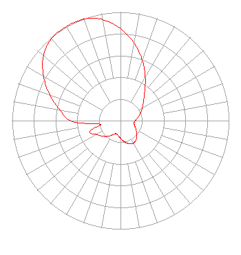 | ||||||||||||||||||||||||
| Azimuth | Ratio | Azimuth | Ratio | Azimuth | Ratio | Azimuth | Ratio | ||||||||||||||||||
| 0 | 0.848 | 10 | 0.725 | 20 | 0.590 | 30 | 0.457 | ||||||||||||||||||
| 40 | 0.346 | 50 | 0.277 | 60 | 0.231 | 70 | 0.195 | ||||||||||||||||||
| 80 | 0.162 | 90 | 0.137 | 100 | 0.127 | 110 | 0.139 | ||||||||||||||||||
| 120 | 0.166 | 130 | 0.198 | 140 | 0.225 | 150 | 0.240 | ||||||||||||||||||
| 160 | 0.226 | 170 | 0.197 | 180 | 0.164 | 190 | 0.136 | ||||||||||||||||||
| 200 | 0.128 | 210 | 0.153 | 220 | 0.190 | 230 | 0.222 | ||||||||||||||||||
| 240 | 0.254 | 250 | 0.301 | 260 | 0.190 | 270 | 0.459 | ||||||||||||||||||
| 280 | 0.570 | 290 | 0.693 | 300 | 0.820 | 310 | 0.928 | ||||||||||||||||||
| 320 | 0.988 | 330 | 1.000 | 340 | 0.995 | 350 | 0.945 | ||||||||||||||||||
Structure Registration Number 1029219 [ASR Heights Differ from WYIN Application] Structure Type: GTOWER Registered To: American Towers LLC Structure Address: 14602 Clark Street (282647) Crown Point, IN County Name: Lake County ASR Issued: 05/25/2023 Date Built: 03/18/2004 Site Elevation: 221 m (725 ft.) Structure Height: 289.6 m (950 ft.) Height Overall: 307.8 m (1010 ft.) Overall Height AMSL: 528.8 m (1735 ft.) FAA Determination: 05/24/2023 FAA Study #: 2023-AGL-5081-OE FAA Circular #: 70/7460-1K Paint & Light FAA Chapters: 4, 7, 12 PRIOR STUDY 2015-AGL-530-OE 41-20-59.3 N 87-23-58.1 W (NAD 83) 41-20-59.2 N 87-23-58.0 W (Converted to NAD 27) |
8625 Indiana Place Merrillville, IN 46410 Phone: 219-756-5656 Not-for-Profit | Title: President And Ceo Date: 02/17/2023 Application Certifier Lakeshore PBS Northwest Indiana Public Broadcasting, Inc. 8625 Indiana Place Merrillville, IN 46410 Applicant Carl E Gluck Carl T Jones Corp 7901 Yarnwood Court Springfield, VA 22153 Technical Consultant John E. Hidle, PE Carl T. Jones Corporation 7901 Yarnwood Court Springfield, VA 22153-2827 Consulting Engineer Brad Deutsch Foster Garvey Pc 1000 Potomac Street, Nw Suite 200 Washington, DC 20007 | |||||||||||||||||||||||
| |||||||||||||||||||||||||