
FCCInfo.com
A Service of Cavell, Mertz & Associates, Inc.
(855) FCC-INFO
|
|
K29KU-D from 03/02/2023 K29KU-D from 08/21/2012 |
|
|
||||||||||||||||
|
|
Status: Construction Permit Application Accepted: 02/24/2023 KBDH-LD CP Expires: 02/28/2026 File Number: -0000211351 FCC Website Links: LMS Facility Details This Application Other KBDH-LD Applications Including Superseded Applications Mailing Address Correspondence for KBDH-LD Correspondence related to application -0000211351 Service Contour - Open Street Map or USGS Map (51 dBu) Service Contour - KML / Google Earth (51 dBu) Rabbit Ears Info Search for KBDH-LD Site Location: 44-02-48.0 N 121-31-54.0 W (NAD 83) Site Location: 44-02-48.6 N 121-31-49.9 W (Converted to NAD 27) ERP: 15 kW Polarization: Horizontally polarized R/C AGL: 48 m (157 ft.) R/C AMSL: 1832 m (6010 ft.) Emission Mask: Full Service Site Elevation: 1784 m. (5853 ft.) Height Overall*: 98.5 m (323 ft.) (* As Filed In This Application, may differ from ASR Data, Below.) Directional Antenna - Antenna Make/Model: Kathrein KAT-2X2 750 10210 Antenna ID: 1010485 Polarization: Horizontally polarized | ||||||||||||||||||
| Antenna Data for Antenna Id: 1010485 KBDH-LD LD File: -0000211351 Kathrein - KAT-2X2 750 10210 Service: LD Standard Pattern: N Pattern and Field Values Include a 25.0° Clockwise Rotation | 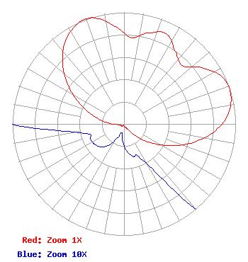 | ||||||||||||||||||
| Azimuth | Ratio | Azimuth | Ratio | Azimuth | Ratio | Azimuth | Ratio | ||||||||||||
| 5 | 0.777 | 15 | 0.844 | 25 | 0.893 | 35 | 0.798 | ||||||||||||
| 45 | 0.740 | 55 | 0.872 | 65 | 0.980 | 75 | 0.991 | ||||||||||||
| 85 | 0.934 | 95 | 0.810 | 105 | 0.642 | 115 | 0.462 | ||||||||||||
| 125 | 0.294 | 135 | 0.159 | 145 | 0.062 | 155 | 0.033 | ||||||||||||
| 165 | 0.030 | 175 | 0.024 | 185 | 0.015 | 195 | 0.008 | ||||||||||||
| 205 | 0.014 | 215 | 0.023 | 225 | 0.029 | 235 | 0.032 | ||||||||||||
| 245 | 0.033 | 255 | 0.034 | 265 | 0.065 | 275 | 0.159 | ||||||||||||
| 285 | 0.286 | 295 | 0.442 | 305 | 0.614 | 315 | 0.780 | ||||||||||||
| 325 | 0.912 | 335 | 0.988 | 340 | 1.000 | 345 | 0.981 | ||||||||||||
| 355 | 0.876 | ||||||||||||||||||
Structure Registration Number 1040317 Structure Type: TOWER Registered To: American Towers LLC Structure Address: Jack Pine Ridge, 9.76 Mi W Bend, OR County Name: Deschutes County ASR Issued: 01/05/2021 Date Built: 04/15/1985 Site Elevation: 1784 m (5853 ft.) Structure Height: 97.6 m (320 ft.) Height Overall: 98.5 m (323 ft.) Overall Height AMSL: 1882.5 m (6176 ft.) FAA Determination: 01/12/1998 FAA Study #: 97-ANM-1533-OE FAA Circular #: 70/7460-1J Paint & Light FAA Chapters: 3, 4, 5, 13 44-02-48.0 N 121-31-54.0 W (NAD 83) 44-02-48.6 N 121-31-49.9 W (Converted to NAD 27) |
Chattanooga, TN 37401 Phone: 423-468-5100 Limited Liability Company | Title: Coo Date: 02/24/2023 Application Certifier Digital Networks-northwest, Llc Chattanooga, TN 37401 Applicant Timothy Z Sawyer T Z Sawyer Technical Consultants 2130 Hutchison Grove Court Suite 100 Falls Church, VA 22043 Technical Consultant Aaron P Shainis, Esq Shainis & Peltzman, Chartered 1850 M Street Nw Suite 240 Washington, DC 20036 FCC Legal Counsel | |||||||||||||||||