
FCCInfo.com
A Service of Cavell, Mertz & Associates, Inc.
(855) FCC-INFO
|
|
|
Virtual Channel 18 |  |
|
|||||||||||||||
|
|
Repacking Information: No changes Status: License Application Accepted: 03/02/2023 License Expires: 06/01/2022 File Number: -0000211780 FCC Website Links: LMS Facility Details This Application Other KAAS-TV Applications Including Superseded Applications Mailing Address Correspondence for KAAS-TV Correspondence related to application -0000211780 Service Contour - Open Street Map or USGS Map (41 dBu) Service Contour - KML / Google Earth (41 dBu) Public Inspection Files Rabbit Ears Info Search for KAAS-TV Site Location: 39-06-16.0 N 97-23-16.0 W (NAD 83) Site Location: 39-06-16.0 N 97-23-14.9 W (Converted to NAD 27) ERP: 150 kW Polarization: Horizontally polarized HAAT: 314 m (1030 ft.) Electrical Beam Tilt: 0.55 degrees R/C AGL: 264 m (866 ft.) R/C AMSL: 720 m (2362 ft.) Site Elevation: 456 m. (1496 ft.) Height Overall*: 275 m (902 ft.) (* As Filed In This Application, may differ from ASR Data, Below.) Directional Antenna - Antenna Make/Model: Propagation System Inc PSIMP40CEC/17-18 Antenna ID: 28829 Polarization: Horizontally polarized | ||||||||||||||||||
| Antenna Data for Antenna Id: 28829 KAAS-TV DT File: -0000211780 Propagation System Inc - PSIMP40CEC/17-18 Service: DT Standard Pattern: Y | 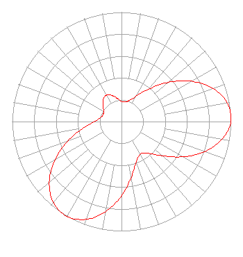 | ||||||||||||||||||
| Azimuth | Ratio | Azimuth | Ratio | Azimuth | Ratio | Azimuth | Ratio | ||||||||||||
| 0 | 0.183 | 10 | 0.182 | 20 | 0.204 | 30 | 0.266 | ||||||||||||
| 40 | 0.388 | 50 | 0.558 | 60 | 0.737 | 70 | 0.888 | ||||||||||||
| 80 | 0.981 | 90 | 1.000 | 100 | 0.933 | 110 | 0.806 | ||||||||||||
| 120 | 0.644 | 130 | 0.487 | 140 | 0.377 | 150 | 0.343 | ||||||||||||
| 160 | 0.394 | 170 | 0.516 | 180 | 0.677 | 190 | 0.835 | ||||||||||||
| 200 | 0.952 | 210 | 1.000 | 220 | 0.968 | 230 | 0.862 | ||||||||||||
| 240 | 0.702 | 250 | 0.521 | 260 | 0.359 | 270 | 0.248 | ||||||||||||
| 280 | 0.198 | 290 | 0.180 | 300 | 0.187 | 310 | 0.221 | ||||||||||||
| 320 | 0.261 | 330 | 0.278 | 340 | 0.254 | 350 | 0.213 | ||||||||||||
Structure Registration Number 1026745 Structure Type: TOWER Registered To: HUTCHINSON COMMUNITY COLLEGE Structure Address: 4.5 Mi. S, 3.0 Mi. W Of Longford, KS County Name: Ottawa County ASR Issued: 08/22/1997 Date Built: 12/01/1987 Site Elevation: 456 m (1496 ft.) Structure Height: 274.5 m (901 ft.) Height Overall: 275 m (902 ft.) Overall Height AMSL: 731 m (2398 ft.) FAA Determination: 10/20/1987 FAA Study #: 87-ACE-0561-OE Paint & Light FAA Chapters: 1, 3, 6, 15, 21 RED LIGHTS/PAINT 39-06-16.0 N 97-23-16.0 W (NAD 83) 39-06-16.0 N 97-23-14.9 W (Converted to NAD 27) |
1200 Seventeenth St Nw Washington, DC 20036 Phone: 202-663-8195 Limited Liability Company | Title: Cfo Date: 03/02/2023 Application Certifier KSAS Licensee, LLC Ksas Licensee, Llc 10706 Beaver Dam Road Cockeysville, MD 21030 Applicant Paul A. Cicelski, Esq Lerman Senter Pllc 2001 L. Street Nw Suite 400 Washington, DC 20036 Legal Representative John E. Hidle, PE Carl T. Jones Corporation 7901 Yarnwood Court Springfield, VA 22153-2827 Consulting Engineer | |||||||||||||||||