
FCCInfo.com
A Service of Cavell, Mertz & Associates, Inc.
(855) FCC-INFO
|
|
WZME from 06/09/1999 WZME from 08/24/1998 WZME from 01/20/1998 WZME from 12/24/1988 WZME from 12/07/1982 WZME from 01/22/1981 |
RF spectrum relinquished in the spectrum auction Virtual Channel 43 |
|
||||||||||||||||
|
|
WZME is a channel sharing guest of WEDW, Stamford, Connecticut Repacking Information: Channel 42 was relinquished in the spectrum auction Status: License Application Accepted: 03/24/2023 License Expires: 04/01/2031 File Number: -0000212909 FCC Website Links: LMS Facility Details This Application Other WZME Applications Including Superseded Applications Mailing Address Correspondence for WZME Correspondence related to application -0000212909 Service Contour - Open Street Map or USGS Map (41 dBu) Service Contour - KML / Google Earth (41 dBu) Public Inspection Files History Cards for WZME Rabbit Ears Info Search for WZME DTS Site Number: 1 Site Location: 41-16-44.3 N 73-11-06.4 W (NAD 83) Site Location: 41-16-44.0 N 73-11-08.0 W (Converted to NAD 27) ERP: 200 kW Polarization: Elliptically polarized HAAT: 219 m (719 ft.) Electrical Beam Tilt: 1.50 degrees R/C AGL: 145 m (476 ft.) R/C AMSL: 303.5 m (996 ft.) Site Elevation: 158.5 m. (520 ft.) Height Overall*: 151.2 m (496 ft.) (* As Filed In This Application, may differ from ASR Data, Below.) Directional Antenna - Antenna Make/Model: ATC ATC-BCE618C3RS-V1-21 Antenna ID: 1010561 Polarization: Elliptically polarized | ||||||||||||||||||
| Antenna Data for Antenna Id: 1010561 WZME DD File: -0000212909 ATC - ATC-BCE618C3RS-V1-21 Service: DD Standard Pattern: N Pattern and Field Values Include a 48° Clockwise Rotation | 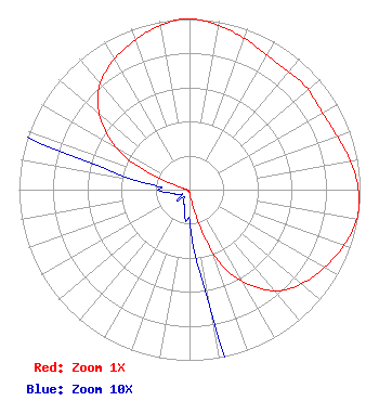 | ||||||||||||||||||
| Azimuth | Ratio | Azimuth | Ratio | Azimuth | Ratio | Azimuth | Ratio | ||||||||||||
| 8 | 0.985 | 18 | 0.950 | 28 | 0.915 | 38 | 0.900 | ||||||||||||
| 48 | 0.910 | 58 | 0.900 | 68 | 0.915 | 78 | 0.950 | ||||||||||||
| 88 | 0.985 | 98 | 1.000 | 108 | 0.970 | 118 | 0.922 | ||||||||||||
| 128 | 0.870 | 138 | 0.795 | 148 | 0.655 | 158 | 0.450 | ||||||||||||
| 168 | 0.110 | 178 | 0.025 | 188 | 0.018 | 198 | 0.010 | ||||||||||||
| 208 | 0.008 | 218 | 0.005 | 228 | 0.010 | 238 | 0.005 | ||||||||||||
| 248 | 0.008 | 258 | 0.010 | 268 | 0.018 | 278 | 0.025 | ||||||||||||
| 288 | 0.110 | 298 | 0.450 | 308 | 0.655 | 318 | 0.795 | ||||||||||||
| 328 | 0.870 | 338 | 0.922 | 348 | 0.970 | 358 | 1.000 | ||||||||||||
Structure Registration Number 1205267 Structure Type: GTOWER Registered To: Pinnacle Towers LLC Structure Address: Booth Hill Road Trumbull, CT County Name: Fairfield County ASR Issued: 09/01/2022 Date Built: 06/01/1953 Site Elevation: 158.5 m (520 ft.) Structure Height: 140.2 m (460 ft.) Height Overall: 151.2 m (496 ft.) Overall Height AMSL: 309.7 m (1016 ft.) FAA Determination: 11/05/2020 FAA Study #: 2020-ANE-6216-OE FAA Circular #: 70/7460-1L Paint & Light FAA Chapters: 4, 8, 12 PRIOR STUDY 2020-ANE-5789-OE 41-16-44.3 N 73-11-06.4 W (NAD 83) 41-16-44.0 N 73-11-08.0 W (Converted to NAD 27) |
26 North Halsted Street Chicago, IL 60661 Phone: 312-705-2600 Limited Liability Company | Application Certifier NRJ TV NY LICENSE CO., LLC Nrj Tv Ny License Co., Llc 722 S. Denton Tap Road Suite 130 Coppell, TX 75019 Applicant Ari Meltzer Wiley Rein Llp 1776 K Street Nw Washington, DC 20006 | |||||||||||||||||