
FCCInfo.com
A Service of Cavell, Mertz & Associates, Inc.
(855) FCC-INFO
|
|
WSWY-LD from 10/16/2015 WSWY-LD from 08/01/2001 |
|
|
||||||||||||||||||||
|
|
Status: Application Application Accepted: 04/05/2023 License Expires: 09/28/2024 File Number: -0000213526 FCC Website Links: LMS Facility Details This Application Other WSWY-LD Applications Including Superseded Applications Mailing Address Correspondence for WSWY-LD Correspondence related to application -0000213526 Service Contour - Open Street Map or USGS Map (51 dBu) Service Contour - KML / Google Earth (51 dBu) Rabbit Ears Info Search for WSWY-LD Site Location: 39-53-39.2 N 86-12-20.5 W (NAD 83) Site Location: 39-53-39.1 N 86-12-20.5 W (Converted to NAD 27) ERP: 15 kW Polarization: Horizontally polarized R/C AGL: 187 m (614 ft.) R/C AMSL: 439.7 m (1443 ft.) Emission Mask: Full Service Site Elevation: 252.7 m. (829 ft.) Height Overall*: 307.8 m (1010 ft.) (* As Filed In This Application, may differ from ASR Data, Below.) Directional Antenna - Antenna Make/Model: Propagation System Inc PSILP16AB Antenna ID: 1010609 Polarization: Horizontally polarized
| ||||||||||||||||||||||
| Antenna Data for Antenna Id: 1010609 WSWY-LD LD File: -0000213526 Propagation System Inc - PSILP16AB Service: LD Standard Pattern: N Pattern and Field Values Include a 125° Clockwise Rotation | 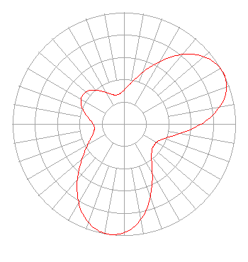 | ||||||||||||||||||||||
| Azimuth | Ratio | Azimuth | Ratio | Azimuth | Ratio | Azimuth | Ratio | ||||||||||||||||
| 5 | 0.334 | 15 | 0.427 | 25 | 0.566 | 35 | 0.733 | ||||||||||||||||
| 45 | 0.883 | 55 | 0.976 | 63 | 1.000 | 65 | 0.998 | ||||||||||||||||
| 75 | 0.936 | 85 | 0.788 | 95 | 0.595 | 105 | 0.434 | ||||||||||||||||
| 115 | 0.351 | 125 | 0.330 | 135 | 0.351 | 145 | 0.434 | ||||||||||||||||
| 155 | 0.595 | 165 | 0.788 | 175 | 0.936 | 185 | 0.998 | ||||||||||||||||
| 187 | 1.000 | 195 | 0.976 | 205 | 0.883 | 215 | 0.733 | ||||||||||||||||
| 225 | 0.566 | 235 | 0.427 | 245 | 0.334 | 255 | 0.282 | ||||||||||||||||
| 265 | 0.268 | 275 | 0.297 | 285 | 0.361 | 295 | 0.426 | ||||||||||||||||
| 305 | 0.452 | 315 | 0.426 | 325 | 0.361 | 335 | 0.297 | ||||||||||||||||
| 345 | 0.268 | 355 | 0.282 | ||||||||||||||||||||
Structure Registration Number 1253064 Structure Type: GTOWER Registered To: American Towers LLC Structure Address: 7701 Walnut Drive (282661) Indianapolis, IN County Name: Marion County ASR Issued: 02/29/2024 Date Built: 07/24/2006 Site Elevation: 252.7 m (829 ft.) Structure Height: 259 m (850 ft.) Height Overall: 307.8 m (1010 ft.) Overall Height AMSL: 560.5 m (1839 ft.) FAA Determination: 06/29/2015 FAA Study #: 2015-AGL-6839-OE FAA Circular #: 70/7460-1K Paint & Light FAA Chapters: 4, 9, 12 PRIOR STUDY 2005-AGL-965-OE 39-53-39.2 N 86-12-20.5 W (NAD 83) 39-53-39.1 N 86-12-20.5 W (Converted to NAD 27) |
Chattanooga, TN 37401 Phone: 423-468-5100 Limited Liability Company | Title: Coo Date: 04/05/2023 Application Certifier Digital Networks-Midwest, LLC Digital Networks-midwest, Llc Chattanooga, TN 37401 Applicant Timothy Z Sawyer T Z Sawyer Technical Consultants 2130 Hutchison Grove Court Suite 100 Falls Church, VA 22043 Technical Consultants Aaron P Shainis Shainis & Peltzman, Chartered 1850 M St. Nw Suite 240 Washington, DC 20036 FCC Legal Counsel | |||||||||||||||||||||