
FCCInfo.com
A Service of Cavell, Mertz & Associates, Inc.
(855) FCC-INFO
|
|
WGSI-CD from 08/30/2001 WGSI-CD from 01/14/2000 WGSI-CD from 05/09/1991 WGSI-CD from 05/22/1991 WGSI-CD from 03/23/1988 |
RF spectrum relinquished in the spectrum auction |
|
||||||||||||||||
|
|
WGSI-CD is a channel sharing guest of WGSC-CD, Murrells Inlet, South Carolina Repacking Information: Channel 11 was relinquished in the spectrum auction Status: License Application Accepted: 04/12/2023 License Expires: 12/01/2020 File Number: -0000213739 FCC Website Links: LMS Facility Details This Application Other WGSI-CD Applications Including Superseded Applications Mailing Address Correspondence for WGSI-CD Correspondence related to application -0000213739 Service Contour - Open Street Map or USGS Map (48 dBu) Service Contour - KML / Google Earth (48 dBu) Public Inspection Files Rabbit Ears Info Search for WGSI-CD Site Location: 33-33-52.0 N 79-03-07.0 W (NAD 83) Site Location: 33-33-51.4 N 79-03-07.9 W (Converted to NAD 27) ERP: 0.8 kW Polarization: Elliptically polarized R/C AGL: 76.2 m (250 ft.) R/C AMSL: 83.5 m (274 ft.) Emission Mask: Full Service Site Elevation: 7.3 m. (24 ft.) Height Overall*: 96 m (315 ft.) (* As Filed In This Application, may differ from ASR Data, Below.) Directional Antenna - Antenna Make/Model: Aldena ALP0704710 Antenna ID: 1008075 Polarization: Elliptically polarized | ||||||||||||||||||
| Antenna Data for Antenna Id: 1008075 WGSI-CD DC File: -0000213739 Aldena - ALP0704710 Service: DC Standard Pattern: Y | 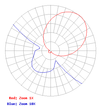 | ||||||||||||||||||
| Azimuth | Ratio | Azimuth | Ratio | Azimuth | Ratio | Azimuth | Ratio | ||||||||||||
| 0 | 0.671 | 10 | 0.794 | 20 | 0.898 | 30 | 0.970 | ||||||||||||
| 40 | 1.000 | 50 | 0.981 | 60 | 0.920 | 70 | 0.824 | ||||||||||||
| 80 | 0.706 | 90 | 0.577 | 100 | 0.450 | 110 | 0.334 | ||||||||||||
| 120 | 0.233 | 130 | 0.148 | 140 | 0.079 | 150 | 0.030 | ||||||||||||
| 160 | 0.029 | 170 | 0.040 | 180 | 0.045 | 190 | 0.048 | ||||||||||||
| 200 | 0.051 | 210 | 0.054 | 220 | 0.055 | 230 | 0.053 | ||||||||||||
| 240 | 0.047 | 250 | 0.040 | 260 | 0.036 | 270 | 0.033 | ||||||||||||
| 280 | 0.025 | 290 | 0.030 | 300 | 0.070 | 310 | 0.137 | ||||||||||||
| 320 | 0.219 | 330 | 0.313 | 340 | 0.421 | 350 | 0.542 | ||||||||||||
Structure Registration Number 1045945 Structure Type: TOWER Registered To: Horry Telephone Cooperative, Inc. Structure Address: 1310 Pond Road Murrells Inlet, SC County Name: Georgetown County ASR Issued: 01/20/2011 Date Built: 08/02/1996 Site Elevation: 7.3 m (24 ft.) Structure Height: 96 m (315 ft.) Height Overall: 96 m (315 ft.) Overall Height AMSL: 103.3 m (339 ft.) FAA Determination: 06/12/1996 FAA Study #: 96-ASO-2380-OE FAA Circular #: 70/7460-1J Paint & Light FAA Chapters: 4, 5, 6, 8, 13 33-33-52.0 N 79-03-07.0 W (NAD 83) 33-33-51.4 N 79-03-07.9 W (Converted to NAD 27) |
8317 Front Beach Road Suite 26 Panama City, FL 32407 Phone: 850-234-2773 Corporation | Application Certifier BEACH TV OF SOUTH CAROLINA, INC. Beach Tv Of South Carolina, Inc. 8317 Front Beach Road Suite 23 Panama City, FL 32407 Applicant Kathleen Victory, Esq Fletcher Heald & Hildreth, Plc. 1300 N. 17th Street Arlington, VA 22209 FCC Counsel | |||||||||||||||||