
FCCInfo.com
A Service of Cavell, Mertz & Associates, Inc.
(855) FCC-INFO
|
|
KQVE-LD from 08/25/2008 |
|
|
||||||||||||||||
|
|
Status: License Application Accepted: 04/27/2023 License Expires: 08/01/2022 File Number: -0000214253 FCC Website Links: LMS Facility Details This Application Other KQVE-LD Applications Including Superseded Applications Mailing Address Correspondence for KQVE-LD Correspondence related to application -0000214253 Service Contour - Open Street Map or USGS Map (48 dBu) Service Contour - KML / Google Earth (48 dBu) Rabbit Ears Info Search for KQVE-LD Site Location: 29-26-29.9 N 98-30-22.8 W (NAD 83) Site Location: 29-26-29.1 N 98-30-21.7 W (Converted to NAD 27) ERP: 3 kW Polarization: Circularly polarized R/C AGL: 113 m (371 ft.) R/C AMSL: 320.2 m (1051 ft.) Emission Mask: Full Service Site Elevation: 207.2 m. (680 ft.) Height Overall*: 152 m (499 ft.) (* As Filed In This Application, may differ from ASR Data, Below.) Directional Antenna - Antenna Make/Model: Systems With Reliability Inc. SWCVL4WC/13-CP Antenna ID: 1010657 Polarization: Circularly polarized | ||||||||||||||||||
| Antenna Data for Antenna Id: 1010657 KQVE-LD LD File: -0000214253 Systems With Reliability Inc. - SWCVL4WC/13-CP Service: LD Standard Pattern: N Pattern and Field Values Include a 200° Clockwise Rotation | 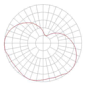 | ||||||||||||||||||
| Azimuth | Ratio | Azimuth | Ratio | Azimuth | Ratio | Azimuth | Ratio | ||||||||||||
| 0 | 0.300 | 10 | 0.220 | 20 | 0.210 | 30 | 0.220 | ||||||||||||
| 40 | 0.300 | 50 | 0.400 | 60 | 0.500 | 70 | 0.600 | ||||||||||||
| 80 | 0.680 | 90 | 0.770 | 100 | 0.850 | 110 | 0.920 | ||||||||||||
| 120 | 0.970 | 130 | 1.000 | 140 | 1.000 | 150 | 0.950 | ||||||||||||
| 160 | 0.940 | 170 | 0.930 | 180 | 0.950 | 190 | 0.980 | ||||||||||||
| 200 | 1.000 | 210 | 0.980 | 220 | 0.950 | 230 | 0.930 | ||||||||||||
| 240 | 0.940 | 250 | 0.950 | 260 | 1.000 | 270 | 1.000 | ||||||||||||
| 280 | 0.970 | 290 | 0.920 | 300 | 0.850 | 310 | 0.770 | ||||||||||||
| 320 | 0.680 | 330 | 0.600 | 340 | 0.500 | 350 | 0.400 | ||||||||||||
Structure Registration Number 1214327 Structure Type: GTOWER Registered To: American Towers LLC Structure Address: 1010 W. Laurel St. (atc Site # 282679) San Antonio, TX County Name: Bexar County ASR Issued: 05/24/2016 Date Built: 07/12/2001 Site Elevation: 207.2 m (680 ft.) Structure Height: 152 m (499 ft.) Height Overall: 152 m (499 ft.) Overall Height AMSL: 359.2 m (1178 ft.) FAA Determination: 03/16/2016 FAA Study #: 2016-ASW-2905-OE FAA Circular #: 70/7460-1L Paint & Light FAA Chapters: 4, 8, 12 PRIOR STUDY 2000-ASW-1251-OE 29-26-29.9 N 98-30-22.8 W (NAD 83) 29-26-29.1 N 98-30-21.7 W (Converted to NAD 27) |
3901 Highway 121 South Bedford, TX 76021 Phone: 817-571-1229 Applicant | Title: Manager Date: 04/27/2023 Application Certifier WORD OF GOD FELLOWSHIP, INC. Word Of God Fellowship, Inc. 3901 Highway 121 South Bedford, TX 76021 Applicant RICHARD C GOETZ R & L Media Systems 135 N Country Club Dr Hendersonville, TN 37075 BROADCAST CONSULTANT | |||||||||||||||||