
FCCInfo.com
A Service of Cavell, Mertz & Associates, Inc.
(855) FCC-INFO
|
|
K36OD-D from 10/16/2018 K36OD-D from 02/03/2012 K36OD-D from 10/15/1992 |
|
|
|||||||||||||||||||||
|
|
Status: License Application Accepted: 06/09/2023 License Expires: 02/01/2023 File Number: -0000216480 FCC Website Links: LMS Facility Details This Application Other K36OD-D Applications Including Superseded Applications Mailing Address Correspondence for K36OD-D Correspondence related to application -0000216480 Service Contour - Open Street Map or USGS Map (51 dBu) Service Contour - KML / Google Earth (51 dBu) Rabbit Ears Info Search for K36OD-D Site Location: 43-52-24.4 N 121-30-15.1 W (NAD 83) Site Location: 43-52-25.0 N 121-30-11.0 W (Converted to NAD 27) ERP: 0.38 kW Polarization: Horizontally polarized R/C AGL: 15 m (49 ft.) R/C AMSL: 1516.1 m (4974 ft.) Emission Mask: Stringent Site Elevation: 1501.1 m. (4925 ft.) Height Overall*: 16.8 m (55 ft.) (* As Filed In This Application, may differ from ASR Data, Below.) Directional Antenna - Antenna Make/Model: Kathrein 1x2 750 10210 Array Antenna ID: 1010801 Polarization: Horizontally polarized
| |||||||||||||||||||||||
| Antenna Data for Antenna Id: 1010801 K36OD-D LD File: -0000216480 Kathrein - 1x2 750 10210 Array Service: LD Standard Pattern: N Pattern and Field Values Include a 100° Clockwise Rotation | 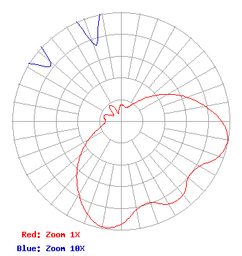 | |||||||||||||||||||||||
| Azimuth | Ratio | Azimuth | Ratio | Azimuth | Ratio | Azimuth | Ratio | |||||||||||||||||
| 0 | 0.150 | 10 | 0.143 | 20 | 0.132 | 30 | 0.158 | |||||||||||||||||
| 40 | 0.228 | 50 | 0.349 | 60 | 0.493 | 70 | 0.641 | |||||||||||||||||
| 80 | 0.785 | 90 | 0.925 | 100 | 0.999 | 101 | 1.000 | |||||||||||||||||
| 110 | 0.953 | 120 | 0.832 | 130 | 0.807 | 140 | 0.886 | |||||||||||||||||
| 150 | 0.879 | 160 | 0.796 | 170 | 0.827 | 180 | 0.948 | |||||||||||||||||
| 190 | 0.986 | 200 | 0.906 | 210 | 0.771 | 220 | 0.632 | |||||||||||||||||
| 230 | 0.485 | 240 | 0.344 | 250 | 0.228 | 260 | 0.161 | |||||||||||||||||
| 270 | 0.140 | 280 | 0.156 | 290 | 0.162 | 300 | 0.108 | |||||||||||||||||
| 310 | 0.085 | 320 | 0.165 | 330 | 0.160 | 340 | 0.076 | |||||||||||||||||
| 350 | 0.104 | |||||||||||||||||||||||
Structure Registration Number 1249718 Structure Type: POLE Registered To: NPG of Oregon, Inc. Structure Address: Spring River Butte Sunriver, OR County Name: Deschutes County ASR Issued: 05/11/2015 Date Built: 01/01/1980 Site Elevation: 1501.1 m (4925 ft.) Structure Height: 16.8 m (55 ft.) Height Overall: 16.8 m (55 ft.) Overall Height AMSL: 1517.9 m (4980 ft.) FAA Determination: 08/09/2005 FAA Study #: 2005-ANM-1376-OE Paint & Light FAA Chapters: NONE 43-52-24.4 N 121-30-15.1 W (NAD 83) 43-52-25.0 N 121-30-11.0 W (Converted to NAD 27) |
825 Edmond Street Saint Joseph, MO 64501 Phone: 816-271-8505 Corporation | Title: Evp And Cfo Of Parent, Npgco Date: 06/09/2023 Application Certifier NPG of Oregon, Inc. Npg Of Oregon, Inc. 825 Edmond Street Saint Joseph, MO 64501 Applicant Louis R duTreil, Jr Dutreil Lundin & Rackley Inc. 5212 Station Way Sarasota, FL 34233 Technical Consultant Elizabeth E. Spainhour Brooks, Pierce Et Al. 150 Fayetteville Street Suite 1700 Raleigh, NC 27601 | ||||||||||||||||||||||