
FCCInfo.com
A Service of Cavell, Mertz & Associates, Inc.
(855) FCC-INFO
|
|
WRAY-TV from 09/29/1992 WRAY-TV from 03/27/1992 WRAY-TV from 02/18/1992 |
RF spectrum relinquished in the spectrum auction Virtual Channel 30 |
|
||||||||||||||||
|
|
WRAY-TV is a channel sharing guest of WUNC-TV, Chapel Hill, North Carolina Repacking Information: Channel 42 was relinquished in the spectrum auction Status: License Application Accepted: 05/30/2023 License Expires: 12/01/2020 File Number: -0000215304 FCC Website Links: LMS Facility Details This Application Other WRAY-TV Applications Including Superseded Applications Mailing Address Correspondence for WRAY-TV Correspondence related to application -0000215304 Service Contour - Open Street Map or USGS Map (41 dBu) Service Contour - KML / Google Earth (41 dBu) Public Inspection Files Rabbit Ears Info Search for WRAY-TV Site Location: 35-51-59.0 N 79-10-00.5 W (NAD 83) Site Location: 35-51-58.5 N 79-10-01.5 W (Converted to NAD 27) ERP: 1000 kW Polarization: Elliptically polarized HAAT: 461.9 m (1515 ft.) Electrical Beam Tilt: 0.8 degrees R/C AGL: 385.5 m (1265 ft.) R/C AMSL: 611.7 m (2007 ft.) Site Elevation: 226.2 m. (742 ft.) Height Overall*: 394.4 m (1294 ft.) (* As Filed In This Application, may differ from ASR Data, Below.) Directional Antenna - Antenna Make/Model: R.F. Systems SAA22-ATW_CX-E300-ET6R-20 Antenna ID: 1006990 Polarization: Elliptically polarized | ||||||||||||||||||
| Antenna Data for Antenna Id: 1006990 WRAY-TV DT File: -0000215304 R.F. Systems - SAA22-ATW_CX-E300-ET6R-20 Service: DT Standard Pattern: Y | 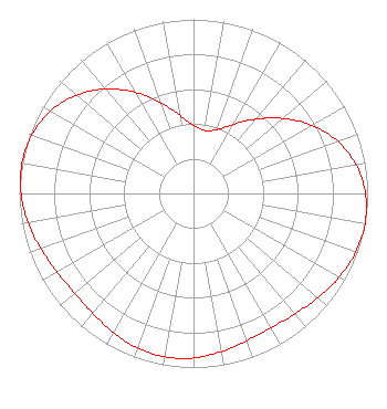 | ||||||||||||||||||
| Azimuth | Ratio | Azimuth | Ratio | Azimuth | Ratio | Azimuth | Ratio | ||||||||||||
| 0 | 0.391 | 10 | 0.367 | 20 | 0.391 | 30 | 0.458 | ||||||||||||
| 40 | 0.557 | 50 | 0.671 | 60 | 0.783 | 70 | 0.879 | ||||||||||||
| 80 | 0.948 | 90 | 0.987 | 100 | 1.000 | 110 | 0.990 | ||||||||||||
| 120 | 0.965 | 130 | 0.932 | 140 | 0.904 | 150 | 0.891 | ||||||||||||
| 160 | 0.899 | 170 | 0.922 | 180 | 0.945 | 190 | 0.954 | ||||||||||||
| 200 | 0.945 | 210 | 0.922 | 220 | 0.899 | 230 | 0.891 | ||||||||||||
| 240 | 0.904 | 250 | 0.932 | 260 | 0.965 | 270 | 0.990 | ||||||||||||
| 280 | 1.000 | 290 | 0.987 | 300 | 0.948 | 310 | 0.879 | ||||||||||||
| 320 | 0.783 | 330 | 0.671 | 340 | 0.557 | 350 | 0.458 | ||||||||||||
Structure Registration Number 1014574 Structure Type: GTOWER Registered To: UNIVERSITY OF NORTH CAROLINA Structure Address: 4401 Jones Ferry Road Chapel Hill, NC County Name: Chatham County ASR Issued: 11/21/2023 Date Built: 02/19/2024 Site Elevation: 226.2 m (742 ft.) Structure Height: 360.6 m (1183 ft.) Height Overall: 394.4 m (1294 ft.) Overall Height AMSL: 620.6 m (2036 ft.) FAA Determination: 04/25/2023 FAA Study #: 2022-ASO-42340-OE FAA Circular #: 70/7460-1M Paint & Light FAA Chapters: 4, 9, 15 PRIOR STUDY 2010-ASO-1608-OE 35-51-59.0 N 79-10-00.5 W (NAD 83) 35-51-58.5 N 79-10-01.5 W (Converted to NAD 27) |
Marion, IL 62959 Phone: 618-997-9333 Not-for-Profit | Application Certifier . Radiant Life Ministries, Inc. Marion, IL 62959 Applicant Colby M. May, Esq. Colby M. May, Esq., P.c. 7010 Little River Turnpike Suite 440 Annandale, VA 22003 Attorney at Law | |||||||||||||||||