
FCCInfo.com
A Service of Cavell, Mertz & Associates, Inc.
(855) FCC-INFO
|
|
W34DV-D from 05/28/2015 W34DV-D from 11/07/2008 W34DV-D from 01/16/1984 |
|
|
||||||||||||||||
|
|
Repacking Information: No changes Status: License (Licensed And Silent) Application Accepted: 06/20/2023 License Expires: 06/01/2021 File Number: -0000216916 FCC Website Links: LMS Facility Details This Application Other WHBH-CD Applications Including Superseded Applications Mailing Address Correspondence for WHBH-CD Correspondence related to application -0000216916 Service Contour - Open Street Map or USGS Map (51 dBu) Service Contour - KML / Google Earth (51 dBu) Public Inspection Files Rabbit Ears Info Search for WHBH-CD Site Location: 34-39-45.0 N 88-34-07.0 W (NAD 83) Site Location: 34-39-44.7 N 88-34-06.8 W (Converted to NAD 27) ERP: 6.2 kW Polarization: Horizontally polarized R/C AGL: 98.6 m (323 ft.) R/C AMSL: 251 m (823 ft.) Emission Mask: Full Service Site Elevation: 152.4 m. (500 ft.) Height Overall*: 104.5 m (343 ft.) (* As Filed In This Application, may differ from ASR Data, Below.) Directional Antenna - Antenna Make/Model: Propagation System Inc PSILP16EAC Antenna ID: 110347 Polarization: Horizontally polarized | ||||||||||||||||||
| Antenna Data for Antenna Id: 110347 WHBH-CD DC File: -0000216916 Propagation System Inc - PSILP16EAC Service: DC Standard Pattern: Y | 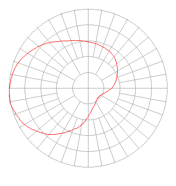 | ||||||||||||||||||
| Azimuth | Ratio | Azimuth | Ratio | Azimuth | Ratio | Azimuth | Ratio | ||||||||||||
| 0 | 0.583 | 10 | 0.569 | 20 | 0.551 | 30 | 0.536 | ||||||||||||
| 40 | 0.512 | 50 | 0.472 | 60 | 0.429 | 70 | 0.386 | ||||||||||||
| 80 | 0.346 | 90 | 0.300 | 100 | 0.247 | 110 | 0.209 | ||||||||||||
| 120 | 0.186 | 130 | 0.179 | 140 | 0.179 | 150 | 0.200 | ||||||||||||
| 160 | 0.235 | 170 | 0.282 | 180 | 0.366 | 190 | 0.476 | ||||||||||||
| 200 | 0.564 | 210 | 0.660 | 220 | 0.765 | 230 | 0.847 | ||||||||||||
| 240 | 0.924 | 250 | 0.967 | 260 | 1.000 | 270 | 0.990 | ||||||||||||
| 280 | 0.969 | 290 | 0.936 | 300 | 0.876 | 310 | 0.814 | ||||||||||||
| 320 | 0.749 | 330 | 0.682 | 340 | 0.636 | 350 | 0.609 | ||||||||||||
Structure Registration Number 1056891 Structure Type: TOWER Registered To: BCI Mississippi Broadband, LLC Structure Address: 406 3rd St Booneville, MS County Name: Prentiss County ASR Issued: 12/03/2014 Date Built: 07/14/1978 Site Elevation: 152.4 m (500 ft.) Structure Height: 104.5 m (343 ft.) Height Overall: 104.5 m (343 ft.) Overall Height AMSL: 256.9 m (843 ft.) FAA Determination: 10/04/2000 FAA Study #: 00-ASO-5626-OE FAA Circular #: 70/7460-1K Paint & Light FAA Chapters: 3, 4, 5, 12 34-39-45.0 N 88-34-07.0 W (NAD 83) 34-39-44.7 N 88-34-06.8 W (Converted to NAD 27) |
500 Summer Street #502 Stamford, CT 06901 Phone: 917-817-3010 Limited Liability Company | Title: Managing Member Date: 06/20/2023 Application Certifier 5gtv, Llc 500 Summer Street #502 Stamford, CT 06901 Applicant Mark Denbo Smithwick & Belendiuk, P.c. 5028 Wisconsin Avenue, N.w. Suite 301 Washington, DC 20016 Counsel | |||||||||||||||||