
FCCInfo.com
A Service of Cavell, Mertz & Associates, Inc.
(855) FCC-INFO
|
|
KMTR from 12/01/1981 |
Virtual Channel 16 |
|
|||||||||||||||||||||||||||||||
|
|
Repacking Information: No changes Status: License Application Accepted: 06/26/2023 License Expires: 02/01/2023 File Number: -0000217139 FCC Website Links: LMS Facility Details This Application Other KMTR Applications Including Superseded Applications Mailing Address Correspondence for KMTR Correspondence related to application -0000217139 Service Contour - Open Street Map or USGS Map (41 dBu) Service Contour - KML / Google Earth (41 dBu) Public Inspection Files Rabbit Ears Info Search for KMTR Site Location: 44-00-06.0 N 123-06-57.0 W (NAD 83) Site Location: 44-00-06.6 N 123-06-52.7 W (Converted to NAD 27) ERP: 300 kW Polarization: Elliptically polarized HAAT: 397.9 m (1305 ft.) Electrical Beam Tilt: 1.0 degree R/C AGL: 198.2 m (650 ft.) R/C AMSL: 592.9 m (1945 ft.) Site Elevation: 394.7 m. (1295 ft.) Height Overall*: 259.3 m (851 ft.) (* As Filed In This Application, may differ from ASR Data, Below.) Directional Antenna - Antenna Make/Model: Dielectric TFU-24JSC/VP-R C170 Antenna ID: 1010841 Polarization: Elliptically polarized
| |||||||||||||||||||||||||||||||||
| Antenna Data for Antenna Id: 1010841 KMTR DT File: -0000217139 Dielectric - TFU-24JSC/VP-R C170 Service: DT Standard Pattern: N | 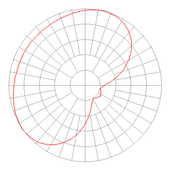 | |||||||||||||||||||||||||||||||||
| Azimuth | Ratio | Azimuth | Ratio | Azimuth | Ratio | Azimuth | Ratio | |||||||||||||||||||||||||||
| 0 | 0.975 | 10 | 0.994 | 15 | 1.000 | 20 | 0.993 | |||||||||||||||||||||||||||
| 30 | 0.964 | 40 | 0.897 | 50 | 0.794 | 60 | 0.660 | |||||||||||||||||||||||||||
| 70 | 0.512 | 80 | 0.370 | 90 | 0.260 | 100 | 0.213 | |||||||||||||||||||||||||||
| 105 | 0.207 | 110 | 0.220 | 120 | 0.238 | 125 | 0.245 | |||||||||||||||||||||||||||
| 130 | 0.238 | 140 | 0.220 | 145 | 0.207 | 150 | 0.213 | |||||||||||||||||||||||||||
| 160 | 0.260 | 170 | 0.370 | 180 | 0.512 | 190 | 0.660 | |||||||||||||||||||||||||||
| 200 | 0.794 | 210 | 0.897 | 220 | 0.964 | 230 | 0.993 | |||||||||||||||||||||||||||
| 235 | 1.000 | 240 | 0.994 | 250 | 0.975 | 260 | 0.950 | |||||||||||||||||||||||||||
| 270 | 0.927 | 280 | 0.911 | 290 | 0.902 | 300 | 0.900 | |||||||||||||||||||||||||||
| 310 | 0.900 | 320 | 0.902 | 330 | 0.911 | 340 | 0.927 | |||||||||||||||||||||||||||
| 350 | 0.950 | |||||||||||||||||||||||||||||||||
Structure Registration Number 1033594 Structure Type: TOWER Registered To: Sinclair Eugene Licensee, LLC Structure Address: 4575 Blanton Rd Eugene, OR County Name: Lane County ASR Issued: 01/10/2017 Date Built: 07/28/1966 Site Elevation: 394.7 m (1295 ft.) Structure Height: 224 m (735 ft.) Height Overall: 259.3 m (851 ft.) Overall Height AMSL: 654 m (2146 ft.) FAA Determination: 07/16/1997 FAA Study #: 97-ANM-0802-OE FAA Circular #: 70/7460-1J Paint & Light FAA Chapters: 3, 4, 5, 13 44-00-06.0 N 123-06-57.0 W (NAD 83) 44-00-06.6 N 123-06-52.7 W (Converted to NAD 27) |
1660 Gulf Blvd., #702 Clearwater Beach, FL 33767 Phone: 208-577-0111 Limited Liability Company | Title: Manager/sole Member Of Licensee's Sole Member Date: 06/26/2023 Application Certifier Kmtr Television, Llc 1660 Gulf Blvd., #702 Clearwater Beach, FL 33767 Applicant Scott R. Flick, Esq Pillsbury Winthrop Shaw Pittman Llp 1200 Seventeenth Street, Nw Washington, DC 20036 John E. Hidle, PE Carl T. Jones Corporation 7901 Yarnwood Court Springfield, VA 22153 Consulting Engineer | ||||||||||||||||||||||||||||||||
|
| |||||||||||||||||||||||||||||||||