
FCCInfo.com
A Service of Cavell, Mertz & Associates, Inc.
(855) FCC-INFO
|
|
KHWB-LD from 01/13/2010 KHWB-LD from 06/19/2009 KHWB-LD from 11/30/1987 KHWB-LD from 08/29/1980 |
|
|
||||||||||||||||
|
|
Status: STA – Special Temporary Authority (Licensed And Silent) Application Accepted: 08/02/2023 STA Expires: 01/15/2024 File Number: -0000218827 FCC Website Links: LMS Facility Details This Application Other KHWB-LD Applications Including Superseded Applications Mailing Address Correspondence for KHWB-LD Correspondence related to application -0000218827 Service Contour - Open Street Map or USGS Map (51 dBu) Service Contour - KML / Google Earth (51 dBu) Rabbit Ears Info Search for KHWB-LD Site Location: 44-06-56.0 N 123-00-01.0 W (NAD 83) Site Location: 44-06-56.6 N 122-59-56.7 W (Converted to NAD 27) ERP: 5.1 kW Polarization: Horizontally polarized R/C AGL: 34 m (112 ft.) R/C AMSL: 677.1 m (2221 ft.) Emission Mask: Stringent Site Elevation: 643.1 m. (2110 ft.) Height Overall*: 123 m (404 ft.) (* As Filed In This Application, may differ from ASR Data, Below.) Directional Antenna - Antenna Make/Model: Scala 4X2KBBU Antenna ID: 20756 Polarization: Horizontally polarized
| ||||||||||||||||||
| Antenna Data for Antenna Id: 20756 KHWB-LD LD File: -0000218827 Scala - 4X2KBBU Service: LD Standard Pattern: Y Pattern and Field Values Include a 230° Clockwise Rotation | 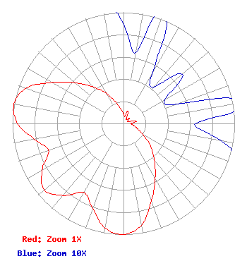 | ||||||||||||||||||
| Azimuth | Ratio | Azimuth | Ratio | Azimuth | Ratio | Azimuth | Ratio | ||||||||||||
| 0 | 0.089 | 10 | 0.065 | 20 | 0.116 | 30 | 0.051 | ||||||||||||
| 40 | 0.043 | 50 | 0.069 | 60 | 0.043 | 70 | 0.051 | ||||||||||||
| 80 | 0.116 | 90 | 0.065 | 100 | 0.089 | 110 | 0.131 | ||||||||||||
| 120 | 0.202 | 130 | 0.316 | 140 | 0.432 | 150 | 0.570 | ||||||||||||
| 160 | 0.738 | 170 | 0.931 | 180 | 1.000 | 190 | 0.955 | ||||||||||||
| 200 | 0.813 | 210 | 0.717 | 220 | 0.846 | 230 | 0.931 | ||||||||||||
| 240 | 0.846 | 250 | 0.717 | 260 | 0.813 | 270 | 0.955 | ||||||||||||
| 280 | 1.000 | 290 | 0.931 | 300 | 0.738 | 310 | 0.570 | ||||||||||||
| 320 | 0.432 | 330 | 0.316 | 340 | 0.202 | 350 | 0.131 | ||||||||||||
Structure Registration Number 1036028 Structure Type: GTOWER Registered To: Black Tail Development, LLC Structure Address: Coburg Ridge, 7 Miles Ne Of Eugene, Oregon Springfield, OR County Name: Lane County ASR Issued: 02/04/2022 Date Built: 01/24/2005 Site Elevation: 643.1 m (2110 ft.) Structure Height: 121.2 m (398 ft.) Height Overall: 123 m (404 ft.) Overall Height AMSL: 766.1 m (2513 ft.) FAA Determination: 09/17/1982 FAA Study #: 82-ANM-536-OE Paint & Light FAA Chapters: 1, 3, 4, 13, 21 RED LIGHTS/PAINT 44-06-56.0 N 123-00-01.0 W (NAD 83) 44-06-56.6 N 122-59-56.7 W (Converted to NAD 27) |
Springfield, OR 97475 Phone: 541-870-7208 Not-for-Profit | Title: Member Date: 08/02/2023 Application Certifier His Word Broadcasting Co. Springfield, OR 97475 Applicant Susan Hansen B. W. St. Clair 2305 Vida Shaw Rd. New Iberia, LA 70563 Consultant Chuck Giddens His Word Broadcasting Co. Springfield, OR 97475 Secretary/Treasure DANIEL Mooney Ridgeline Broadcast Services, Llc 39341 Howard Road Marcola, OR 97454 CHIEF ENGINEER | |||||||||||||||||